METAR & TAF 69G
69G does not publish a METAR.
Showing the nearest reporting station: KOZW (LIVINGSTON COUNTY/SPENCER J HARDY) · 11.8 NM away. Conditions at 69G may differ.
METAR · KOZW
Observed 17:15Z
KOZW 271715Z AUTO 28008KT 10SM CLR 29/18 A2976 RMK AO2 PRESFR
- Wind
- 280° @ 8 kt
- Visibility
- 10 SM
- Temp / Dew
- 29°C / 18°C
- Altimeter
- 29.76 inHg
- Clouds
- CLR
- Density alt
- 3,020 ft
- Ceiling
- Unlimited
- Rules
- VFR
Airport info & contacts
Manager on record, flight service, ARTCC, attendance schedule and pattern altitude — published by the FAA and refreshed every 28 days.
Location
- From city
- 2 NM SE
- VFR sectional
- DETROIT
- ARTCC
- ZOB · CLEVELAND
- NOTAM facility
- LAN (NOTAM-D)
Airport manager
- Name
- MICHAEL S CAMPBELL
- Phone
- 734-498-2075
- Address
- 19935 DOYLE RD, GREGORY MI 48137-9720
Flight service · Hours
- FSS LAN
- LANSING1-800-WX-BRIEF
- Attendance
- APR-NOV · MON-WED · IREG
- APR-NOV · SAT-SUN · DALGT
Frequencies
Tap any row to copy the frequency to your clipboard.
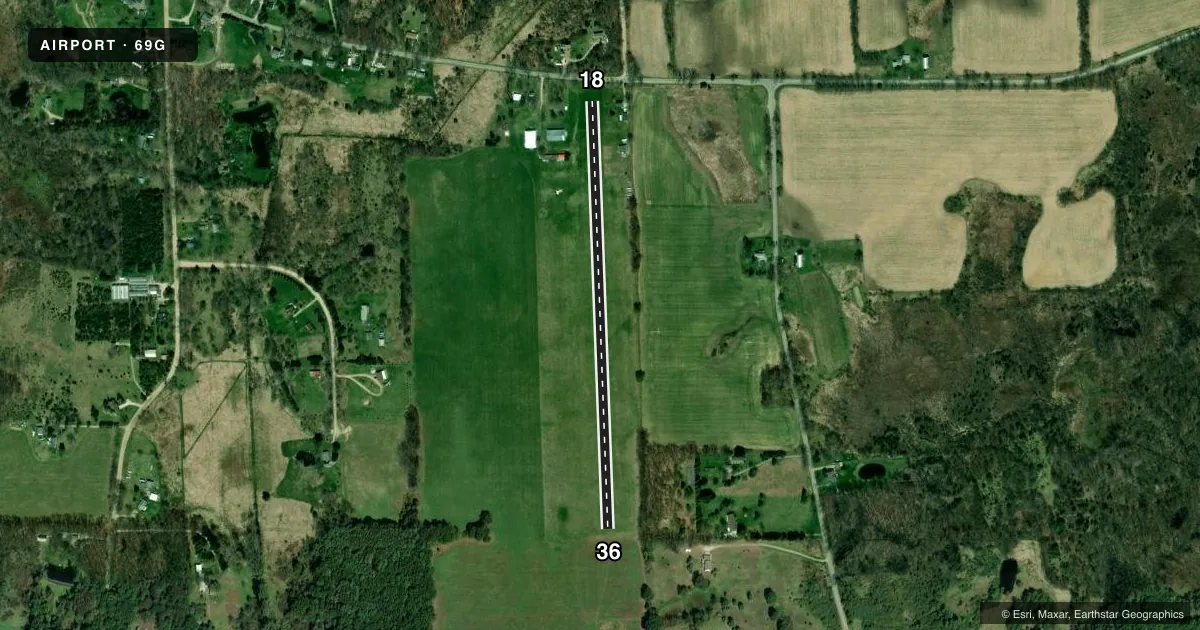
Runways & pattern
Full pagePattern entry · RWY 36
LEFT TRAFFICRunway end performance
| End | TORA | TODA | ASDA | LDA | VGSI | Approach lights | Obstruction |
|---|---|---|---|---|---|---|---|
| 18 | — | — | — | — | — | — | 22', tree, 0' from thr, 125' R of cntrln, slope 0 |
| 36 | — | — | — | — | — | — | 66', tree, 702' from thr, 168' R of cntrln, slope 10 |
Declared distances in feet. TORA = takeoff run available, TODA = takeoff distance, ASDA = accelerate-stop, LDA = landing distance.
Airport sketch
Runways drawn to scale from FAA survey coordinates, rendered over satellite imagery. Not for navigation.
Approaches & charts
Services on the field
Fuel grades, oxygen, maintenance, ramp storage and lighting — as declared to the FAA by the airport operator.
Fuel & services
- Fuel
- Not available
- Oxygen (bottled)
- Not available
- Oxygen (bulk)
- Not available
- Airframe repair
- Not available
- Power plant repair
- Not available
- Other services
- GLD
Ramp & ground
- Transient storage
- Tie-down
- Landing fee
- No fee published
- Customs
- Not available
- Wind indicator
- Yes
- Segmented circle
- Yes
Fuel & FBOs
Cheapest 100LL and Jet A on the field and nearby. Always confirm with the FBO before taxi.
Airport notes
Surface conditions, obstructions, local procedures, lighting outages and other notes published with each FAA cycle.
General notes
- EXTSV GLDR OPS ON & INVOF ARPT; GLDRS ALSO USE THE TURF AREA WEST OF RWY 18/36; GLDR FREQ 123.5.
- FOR CD CTC DETROIT APCH AT 734-955-1404.
- DEER & LRG BIRDS ON & INVOF ARPT.
Runway surface & condition
- 18/36NOT PLOWED WINTER.
Approach & departure obstructions
- 18RWY & DTHR MKD WITH 2 FT YELLOW CONES.
- 362 FT YELLOW CONES.
- 18CTLG OBSTN EXCEEDS A 45 DEG SLP. APCH RATIO 16:1 TO DTHR OVR +60 FT TREE, 1007 FT DIST, 0 FT B.
- 18+30 FT PLINE, 50 FT DIST, 125 FT L/R.
Other notes
- ESTABD BFR 1959.
VFR map & nearby airports
VFR sectional. Tap any ICAO chip to open that airport.
Key facts · 69G
Answer card- ICAO
- 69G
- Name
- RICHMOND FLD
- Location
- GREGORY, MICHIGAN
- Elevation
- 921 ft MSL
- Traffic pattern altitude
- 1,921 ft MSL (1,000 AGL)
- Control tower
- Non-towered (use CTAF)
- Total runways
- 1
- Longest runway
- 18/36 · 2,471 ft
- Published ILS approaches
- 0
- Published frequencies
- 1
- Magnetic variation
- –
- Current flight rules
- VFR
- Current wind
- 280° at 8 kt
- Favored runway now
- RWY 36
Richmond Fld sits in Gregory, Michigan. Field elevation is 921 ft MSL. The airport has one runway. The longest is 18/36 at 2,471 ft on turf. There is no control tower. CTAF is 122.9. No ILS approaches are published here.
Pattern altitude is not published. Use 1,000 ft AGL as the standard light-piston pattern reference unless local traffic or the current Chart Supplement says otherwise. The field has extensive glider activity on and near the airport. Gliders also use the turf area west of runway 18/36. That makes traffic scanning important on every leg. Deer and large birds are also reported on and near the airport.
Runway 18 has yellow cones marking the runway and displaced threshold. Runway 36 also has yellow cones at the end. A cataloged obstruction near the 18 approach exceeds a 45 degree slope. There is also a plus 30-foot power line near the 18 side. Runway 18/36 is not plowed in winter. For clearance delivery, contact Detroit Approach at 734-955-1404. No on-field FBOs are listed, so verify services with the airport operator or call the field directly before arrival.