METAR & TAF 65G
65G does not publish a METAR.
Showing the nearest reporting station: KOZW (LIVINGSTON COUNTY/SPENCER J HARDY) · 6.3 NM away. Conditions at 65G may differ.
METAR · KOZW
Observed 16:15Z
KOZW 271615Z AUTO 27014G18KT 10SM FEW025 SCT030 29/20 A2981 RMK AO2
- Wind
- 270° @ 14G18 kt
- Visibility
- 10 SM
- Temp / Dew
- 29°C / 20°C
- Altimeter
- 29.81 inHg
- Clouds
- SCT
- Density alt
- 2,940 ft
- Ceiling
- Unlimited
- Rules
- VFR
Airport info & contacts
Manager on record, flight service, ARTCC, attendance schedule and pattern altitude — published by the FAA and refreshed every 28 days.
Location
- From city
- 3 NM N
- VFR sectional
- DETROIT
- ARTCC
- ZOB · CLEVELAND
- NOTAM facility
- LAN (NOTAM-D)
Airport manager
- Name
- PAULO ROBERTO PINTO DA SILVA
- Phone
- 517-245-4387
- Address
- 7080 W SHERWOOD RD, FOWLERVILLE MI 48836-9371
Flight service · Hours
- FSS LAN
- LANSING1-800-WX-BRIEF
- Attendance
- JUN-OCT · IREG
Frequencies
Tap any row to copy the frequency to your clipboard.
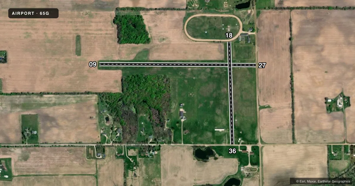
Runways & pattern
Full pagePattern entry · RWY 27
LEFT TRAFFIC| Runway | Heading (°M) | Length | Surface | Traffic |
|---|---|---|---|---|
| 09/27Favored | 85° / 265° | 3,050 ft | TURF | Standard L |
| 18/36 | 173° / 353° | 2,000 ft | TURF | Standard L |
Runway end performance
| End | TORA | TODA | ASDA | LDA | VGSI | Approach lights | Obstruction |
|---|---|---|---|---|---|---|---|
| 09 | — | — | — | — | — | — | 20', gnd, 345' from thr, 125' R of cntrln, slope 17 |
| 27 | — | — | — | — | — | — | 15', road, 30' from thr, 125' R of cntrln, slope 2 |
| 18 | — | — | — | — | — | — | 4', fence, 0' from thr, 75' R of cntrln, slope 1 |
| 36 | — | — | — | — | — | — | 15', road, 25' from thr, 125' R of cntrln, slope 1 |
Declared distances in feet. TORA = takeoff run available, TODA = takeoff distance, ASDA = accelerate-stop, LDA = landing distance.
Airport sketch
Runways drawn to scale from FAA survey coordinates, rendered over satellite imagery. Not for navigation.
Approaches & charts
Services on the field
Fuel grades, oxygen, maintenance, ramp storage and lighting — as declared to the FAA by the airport operator.
Fuel & services
- Fuel
- Not available
- Airframe repair
- Major
- Power plant repair
- Major
- Other services
- PAJA
Ramp & ground
- Transient storage
- Tie-down
- Landing fee
- No fee published
- Customs
- Not available
- Lighting schedule
- SS-SR
- Wind indicator
- Yes
- Segmented circle
- No
Fuel & FBOs
Cheapest 100LL and Jet A on the field and nearby. Always confirm with the FBO before taxi.
Airport notes
Surface conditions, obstructions, local procedures, lighting outages and other notes published with each FAA cycle.
General notes
- ARPT IS COLOCATED WITH E66 HLP, BE ALERT FOR ROTARY WING ACFT.
- EXTSV ACFT TRG, TWO-WAY RDO COMS RQRD.
- FOR CD CTC GREAT LAKES APCH AT 269-459-3345, WHEN APCH CLSD CTC CLEVELAND ARTCC AT 440-774-0224/0490.
- FICONS UNMON NOV-MAY. NO SNOW REMOVAL.
- DEER & LRG BIRDS ON & INVOF ARPT.
Approach & departure obstructions
- 09RWY & DTHR MKD WITH 3 FT YELLOW CONES.
- 18RWY & DTHR MKD WITH 3 FT YELLOW CONES.
- 27RWY & DTHR MKD WITH 3 FT YELLOW CONES.
- 36RWY & DTHR MKD WITH 3 FT YELLOW CONES.
- 09APCH RATIO 20:1 TO DTHR.
- 18APCH RATIO 20:1 TO DTHR OVR +55 FT MKD & LGTD PLINE, 550 FT DIST, 180 FT L/R.
- 27APCH RATIO 20:1 TO DTHR.
- 36APCH RATIO 20:1 TO DTHR.
Other notes
- MANAGERALTN CTC E66 AMGR.
VFR map & nearby airports
VFR sectional. Tap any ICAO chip to open that airport.
Key facts · 65G
Answer card- ICAO
- 65G
- Name
- MAPLE GROVE
- Location
- FOWLERVILLE, MICHIGAN
- Elevation
- 906 ft MSL
- Traffic pattern altitude
- 1,906 ft MSL (1,000 AGL)
- Control tower
- Non-towered (use CTAF)
- Total runways
- 2
- Longest runway
- 09/27 · 3,050 ft
- Published ILS approaches
- 0
- Published frequencies
- 2
- Magnetic variation
- 5°
- Current flight rules
- VFR
- Current wind
- 270° at 14 kt
- Favored runway now
- RWY 27
Maple Grove Airport sits in Fowlerville, Michigan. Field elevation is 906 ft MSL. The airport has two turf runways. The longest is 09/27 at 3,050 ft. There is no control tower, so plan for self-announce traffic on CTAF 122.8. No ILS approaches are published here.
Pattern altitude is not published. Use the standard 1,000 ft AGL for light piston operations unless the current FAA Chart Supplement says otherwise. The field is colocated with E66 HLP, so expect rotary wing traffic in the area. Deer and large birds are also noted on and near the airport. Runways 09, 18, 27 and 36 are marked with 3 ft yellow cones at the runway and displaced threshold. Runway 18 also has a marked and lighted power line on the approach path. The published approach ratio to the displaced threshold on runways 09, 18, 27 and 36 is 20 to 1.
There are no on-field FBOs listed. If you need current fuel or service options, contact the airport operator or the FBO directly by phone before arrival. For clearance delivery, the published remarks point pilots to Great Lakes Approach when it is open. When approach is closed, use Cleveland ARTCC. This is a turf field with two runways, so check surface condition carefully before you go.