METAR & TAF 45G
45G does not publish a METAR.
Showing the nearest reporting station: KOZW (LIVINGSTON COUNTY/SPENCER J HARDY) · 9.7 NM away. Conditions at 45G may differ.
METAR · KOZW
Observed 12:56Z
KOZW 271256Z AUTO 24009KT 9SM CLR 24/22 A2985 RMK AO2
- Wind
- 240° @ 9 kt
- Visibility
- 9 SM
- Temp / Dew
- 24°C / 22°C
- Altimeter
- 29.85 inHg
- Clouds
- CLR
- Density alt
- 2,373 ft
- Ceiling
- Unlimited
- Rules
- VFR
Airport info & contacts
Manager on record, flight service, ARTCC, attendance schedule and pattern altitude — published by the FAA and refreshed every 28 days.
Location
- From city
- 3 NM N
- VFR sectional
- DETROIT
- ARTCC
- ZOB · CLEVELAND
- NOTAM facility
- LAN (NOTAM-D)
Airport manager
- Name
- CLINTON RAY
- Phone
- 810-223-6819
- Address
- 8664 HYNE RD, BRIGHTON MI 48114-8925
Flight service · Hours
- FSS LAN
- LANSING1-800-WX-BRIEF
- Attendance
- IREG
Frequencies
Tap any row to copy the frequency to your clipboard.
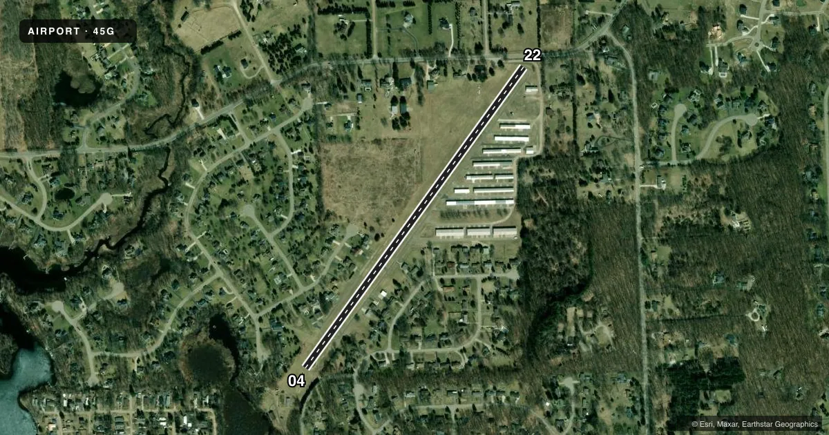
Runways & pattern
Full pagePattern entry · RWY 22
LEFT TRAFFICRunway end performance
| End | TORA | TODA | ASDA | LDA | VGSI | Approach lights | Obstruction |
|---|---|---|---|---|---|---|---|
| 04 | — | — | — | — | — | — | 80', trees, 471' from thr, 125' R of cntrln, slope 3 |
| 22 | — | — | — | — | — | — | 72', trees, 247' from thr, 125' R of cntrln, slope 0 |
Declared distances in feet. TORA = takeoff run available, TODA = takeoff distance, ASDA = accelerate-stop, LDA = landing distance.
Airport sketch
Runways drawn to scale from FAA survey coordinates, rendered over satellite imagery. Not for navigation.
Approaches & charts
Services on the field
Fuel grades, oxygen, maintenance, ramp storage and lighting — as declared to the FAA by the airport operator.
Fuel & services
- Fuel
- Not available
Ramp & ground
- Transient storage
- Tie-down
- Landing fee
- No fee published
- Customs
- Not available
- Wind indicator
- Lighted
- Segmented circle
- No
Fuel & FBOs
Cheapest 100LL and Jet A on the field and nearby. Always confirm with the FBO before taxi.
Airport notes
Surface conditions, obstructions, local procedures, lighting outages and other notes published with each FAA cycle.
General notes
- DEER & LRG BIRDS ON & INVOF ARPT.
- CALL AMGR TO VFY RWY CONDS & SNOW REMOVAL IN WINTER.
- FOR CD CTC DETROIT APCH AT 734-955-1404.
Approach & departure obstructions
- 22PVT ROAD, 100 FT DIST; +9 FT PUB ROAD, 150 FT DIST.
- 04APCH RATIO 1:1 TO DTHR OVR +9 FT TREES, 47 FT DIST, 100 FT L.
- 22CTLG OBSTN EXCEEDS A 45 DEG SLP. APCH RATIO 18:1 TO DTHR OVR +59 FT TREES, 1065 FT DIST, 0 FT B.
Other notes
- ESTABD BFR 1959.
VFR map & nearby airports
VFR sectional. Tap any ICAO chip to open that airport.
Key facts · 45G
Answer card- ICAO
- 45G
- Name
- BRIGHTON
- Location
- BRIGHTON, MICHIGAN
- Elevation
- 973 ft MSL
- Traffic pattern altitude
- 1,973 ft MSL (1,000 AGL)
- Control tower
- Non-towered (use CTAF)
- Total runways
- 1
- Longest runway
- 04/22 · 3,105 ft
- Published ILS approaches
- 0
- Published frequencies
- 1
- Magnetic variation
- 5°
- Current flight rules
- VFR
- Current wind
- 240° at 9 kt
- Favored runway now
- RWY 22
Brighton Airport (45G) is in Brighton, Michigan. The field elevation is 973 ft MSL. It has one runway. Runway 04/22 is 3,105 ft of asphalt, so plan performance with that length in mind.
This is an uncontrolled airport. There is no tower. CTAF is 122.9. No ILS approaches are published. The pattern altitude is not published, so use the standard 1,000 ft AGL for light piston operations unless the current Chart Supplement says otherwise. With the field sitting near Detroit airspace, get your clearance delivery details from Detroit Approach at 734-955-1404 if you need them.
The published remarks matter here. There are trees close to both ends. The 22 approach has a private road and a public road near the runway, plus taller obstacles on final. The 04 approach also has trees close in. Deer and large birds are reported on and near the airport. Call the airport manager before winter operations to verify runway condition and snow removal. No on-field FBOs are listed, so verify fuel and services with the airport operator or call the field directly before arrival.