METAR & TAF 26W
26W does not publish a METAR.
Showing the nearest reporting station: KJXN (JACKSON COUNTY/REYNOLDS FLD) · 10.7 NM away. Conditions at 26W may differ.
METAR · KJXN
Observed 21:56Z
KJXN 262156Z 26006KT 10SM CLR 28/19 A2990 RMK AO2 SLP116 T02830194
- Wind
- 260° @ 6 kt
- Visibility
- 10 SM
- Temp / Dew
- 28°C / 19°C
- Altimeter
- 29.90 inHg
- Clouds
- CLR
- Density alt
- 2,800 ft
- Ceiling
- Unlimited
- Rules
- VFR
Airport info & contacts
Manager on record, flight service, ARTCC, attendance schedule and pattern altitude — published by the FAA and refreshed every 28 days.
Location
- From city
- 4 NM NE
- VFR sectional
- DETROIT
- ARTCC
- ZOB · CLEVELAND
- NOTAM facility
- LAN (NOTAM-D)
Airport manager
- Name
- MICHAEL KRAUS
- Phone
- 517-414-4070
- Address
- 3920 GREY TOWER RD, JACKSON MI 49201-8001
Flight service · Hours
- FSS LAN
- LANSING1-800-WX-BRIEF
- Attendance
- IREG
Frequencies
Tap any row to copy the frequency to your clipboard.
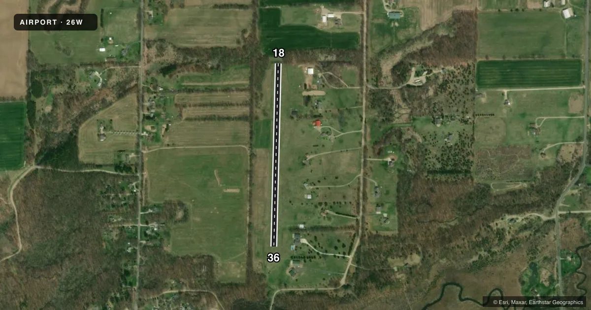
Runways & pattern
Full pagePattern entry · RWY 18
LEFT TRAFFICRunway end performance
| End | TORA | TODA | ASDA | LDA | VGSI | Approach lights | Obstruction |
|---|---|---|---|---|---|---|---|
| 18 | — | — | — | — | — | — | 78', trees, 0' from thr, 98' R of cntrln, slope 0 |
| 36 | — | — | — | — | — | — | 68', trees, 335' from thr, 145' R of cntrln, slope 4 |
Declared distances in feet. TORA = takeoff run available, TODA = takeoff distance, ASDA = accelerate-stop, LDA = landing distance.
Airport sketch
Runways drawn to scale from FAA survey coordinates, rendered over satellite imagery. Not for navigation.
Approaches & charts
Services on the field
Fuel grades, oxygen, maintenance, ramp storage and lighting — as declared to the FAA by the airport operator.
Fuel & services
- Fuel
- Not available
- Oxygen (bottled)
- Not available
- Oxygen (bulk)
- Not available
- Airframe repair
- Not available
- Power plant repair
- Not available
Ramp & ground
- Transient storage
- Tie-down
- Wind indicator
- Yes
- Segmented circle
- No
Fuel & FBOs
Cheapest 100LL and Jet A on the field and nearby. Always confirm with the FBO before taxi.
Airport notes
Surface conditions, obstructions, local procedures, lighting outages and other notes published with each FAA cycle.
General notes
- DEER & LRG BIRDS ON & INVOF ARPT.
- FOR CD CTC GREAT LAKES APCH AT 269-459-3345, WHEN APCH CLSD CTC CLEVELAND ARTCC AT 440-774-0224/0490.
Approach & departure obstructions
- 182 FT YELLOW CONES.
- 362 FT YELLOW CONES.
- 18CTLG OBSTN EXCEEDS A 45 DEG SLP.
Other notes
- ROPES & ANCHORS NOT PRVDD.
VFR map & nearby airports
VFR sectional. Tap any ICAO chip to open that airport.
Key facts · 26W
Answer card- ICAO
- 26W
- Name
- WOLF LAKE
- Location
- NAPOLEON, MICHIGAN
- Elevation
- 980 ft MSL
- Traffic pattern altitude
- 1,980 ft MSL (1,000 AGL)
- Control tower
- Non-towered (use CTAF)
- Total runways
- 1
- Longest runway
- 18/36 · 2,155 ft
- Published ILS approaches
- 0
- Published frequencies
- 1
- Magnetic variation
- 5°
- Current flight rules
- VFR
- Current wind
- 260° at 6 kt
- Favored runway now
- RWY 18
Wolf Lake (26W) sits near Napoleon, Michigan. The field elevation is 980 ft MSL. It has one runway, 18/36, which is 2,155 ft of turf. The airport is not towered. CTAF is 122.9.
No ILS approaches are published here. The pattern altitude is not published in the facts, so use standard 1,000 ft AGL unless the current Chart Supplement says otherwise. That puts the light piston pattern at about 1,980 ft MSL based on the field elevation. Verify before you fly. Published remarks call out yellow cones at both runway ends. They also note an obstruction near runway 18 that exceeds a 45 degree slope. Plan your arrival with that in mind. Deer and large birds are reported on and near the airport.
No on-field FBOs are listed. Contact the airport operator directly or call the field on CTAF for current services before arrival. For clearance delivery, contact Great Lakes Approach. If Approach is closed, use Cleveland ARTCC. This is a small turf field with no tower and no published ILS, so a current chart review matters. Check runway condition, wind and the departure path before you commit.