METAR & TAF 3TE
3TE does not publish a METAR.
Showing the nearest reporting station: KADG (LENAWEE COUNTY) · 11.3 NM away. Conditions at 3TE may differ.
METAR · KADG
Observed 17:53Z
KADG 271753Z AUTO 24009KT 10SM CLR 29/19 A2979 RMK AO2 SLP081 T02940189 10294 20211 58029
- Wind
- 240° @ 9 kt
- Visibility
- 10 SM
- Temp / Dew
- 29°C / 19°C
- Altimeter
- 29.79 inHg
- Clouds
- CLR
- Density alt
- 2,848 ft
- Ceiling
- Unlimited
- Rules
- VFR
Airport info & contacts
Manager on record, flight service, ARTCC, attendance schedule and pattern altitude — published by the FAA and refreshed every 28 days.
Location
- From city
- 2 NM N
- VFR sectional
- DETROIT
- ARTCC
- ZOB · CLEVELAND
- NOTAM facility
- LAN (NOTAM-D)
Airport manager
- Name
- ANDREW K AALTO
- Phone
- 517-423-1122
- Address
- 4330 MACON RD, TECUMSEH MI 49286-9507
Flight service · Hours
- FSS LAN
- LANSING1-800-WX-BRIEF
- Attendance
- IREG
Frequencies
Tap any row to copy the frequency to your clipboard.
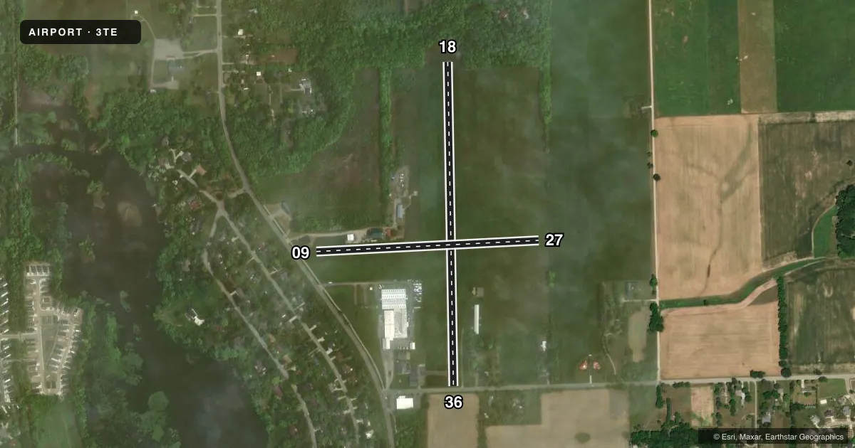
Runways & pattern
Full pagePattern entry · RWY 27
LEFT TRAFFIC| Runway | Heading (°M) | Length | Surface | Traffic |
|---|---|---|---|---|
| 18/36 | 172° / 352° | 2,649 ft | ASPH | Standard L |
| 09/27Favored | 80° / 260° | 1,820 ft | TURF | Standard L |
Runway end performance
| End | TORA | TODA | ASDA | LDA | VGSI | Approach lights | Obstruction |
|---|---|---|---|---|---|---|---|
| 18 | — | — | — | — | — | — | 51', trees, 200' from thr, 30' R of cntrln, slope 0 |
| 36 | — | — | — | — | — | — | 93', tree, 1762' from thr, 38' R of cntrln, slope 16 |
| 09 | — | — | — | — | — | — | 53', trees, 267' from thr, 0' R of cntrln, slope 5 |
| 27 | — | — | — | — | — | — | 5', pole, 100' from thr, 55' R of cntrln, slope 20 |
Declared distances in feet. TORA = takeoff run available, TODA = takeoff distance, ASDA = accelerate-stop, LDA = landing distance.
Airport sketch
Runways drawn to scale from FAA survey coordinates, rendered over satellite imagery. Not for navigation.
Approaches & charts
Services on the field
Fuel grades, oxygen, maintenance, ramp storage and lighting — as declared to the FAA by the airport operator.
Fuel & services
- Fuel
- 100LL
- Oxygen (bottled)
- Not available
- Oxygen (bulk)
- Not available
- Airframe repair
- Major
- Power plant repair
- Major
- Other services
- AVNCS
Ramp & ground
- Transient storage
- Tie-down
- Hangar
- Landing fee
- No fee published
- Customs
- Not available
- Lighting schedule
- SEE RMK
- Wind indicator
- Lighted
- Segmented circle
- Yes
Fuel & FBOs
Cheapest 100LL and Jet A on the field and nearby. Always confirm with the FBO before taxi.
Airport notes
Surface conditions, obstructions, local procedures, lighting outages and other notes published with each FAA cycle.
General notes
- FOR CD CTC DETROIT APCH AT 734-955-1404.
Lighting notes
- ACTVT NSTD LIRL RWY 18/36 - CTAF.
Runway surface & condition
- 09/27CLSD INDEFLY.
- 18/36NSTD LIRL DUE TO COLOR & NON-FRANGIBLE FIXTURE TYPE; NOT FOR PUB USE.
Approach & departure obstructions
- 1820-46 FT SCT TREES, 0-199 FT DIST, 90-125 FT L.
- 3617 FT ROAD, 30 FT DIST, 125 FT L/R.
- 18FADED.
- 36FADED.
- 18APCH RATIO 15:1 TO DTHR OVR 56 FT TREE, 860 FT DIST, 35 FT R.
- 36APCH RATIO 24:1 TO DTHR OVR 93 FT TREE, 2262 FT DIST, 38 FT L.
Other notes
- 18/36EXTSV CRACKING & VEGETATION GROWTH.
VFR map & nearby airports
VFR sectional. Tap any ICAO chip to open that airport.
Key facts · 3TE
Answer card- ICAO
- 3TE
- Name
- AL MEYERS
- Location
- TECUMSEH, MICHIGAN
- Elevation
- 812 ft MSL
- Traffic pattern altitude
- 1,812 ft MSL (1,000 AGL)
- Control tower
- Non-towered (use CTAF)
- Total runways
- 2
- Longest runway
- 18/36 · 2,649 ft
- Published ILS approaches
- 0
- Published frequencies
- 3
- Magnetic variation
- 7°
- Current flight rules
- VFR
- Current wind
- 240° at 9 kt
- Favored runway now
- RWY 27
Al Meyers Airport is in Tecumseh, Michigan. The field elevation is 812 ft MSL. It has two runways. The longest is 18/36 at 2,649 ft asphalt. Runway 09/27 is 1,820 ft turf, but it is closed indefinitely. There is no control tower. CTAF is 122.9. Detroit Approach handles clearance delivery. The published approach frequencies are 118.95 and 284.0.
No ILS approaches are published here. The traffic pattern altitude is not published, so use the standard 1,000 ft AGL for light piston traffic unless the current FAA Chart Supplement says otherwise. The on-field FBO is Al Meyers Airport. It carries 100LL. Call the field directly at (517) 423-1122 before you go if you need current service details.
Read the runway remarks before you launch. Runway 18 markings are faded. Runway 36 markings are also faded. Runway 18/36 has extensive cracking and vegetation growth. The published notes also say the runway lights are nonstandard low-intensity units and are not for published use. They can be activated from CTAF. There are tree and road obstructions near both ends, so plan your approach carefully and check the current Chart Supplement before a night or low-weather arrival.