METAR & TAF KADG
Current METAR
Observed 14:53Z
KADG 271453Z AUTO 24007KT 10SM CLR 26/22 A2987 RMK AO2 SLP111 T02610217 58008
- Wind
- 240° @ 7 kt
- Visibility
- 10 SM
- Temp / Dew
- 26°C / 22°C
- Altimeter
- 29.87 inHg
- Clouds
- CLR
- Density alt
- 2,377 ft
- Ceiling
- Unlimited
- Rules
- VFR
Airport info & contacts
Manager on record, flight service, ARTCC, attendance schedule and pattern altitude — published by the FAA and refreshed every 28 days.
Location
- From city
- 3 NM SW
- VFR sectional
- DETROIT
- ARTCC
- ZOB · CLEVELAND
- NOTAM facility
- ADG (NOTAM-D)
Airport manager
- Name
- THOMAS KENDZIORA III
- Phone
- 517-265-8993
- Address
- 2651 W CADMUS RD, ADRIAN MI 49221-8709
Flight service · Hours
- FSS LAN
- LANSING1-800-WX-BRIEF
- Attendance
- MON-FRI · 0800-1630
- SAT · ON CALL
Frequencies
Tap any row to copy the frequency to your clipboard.
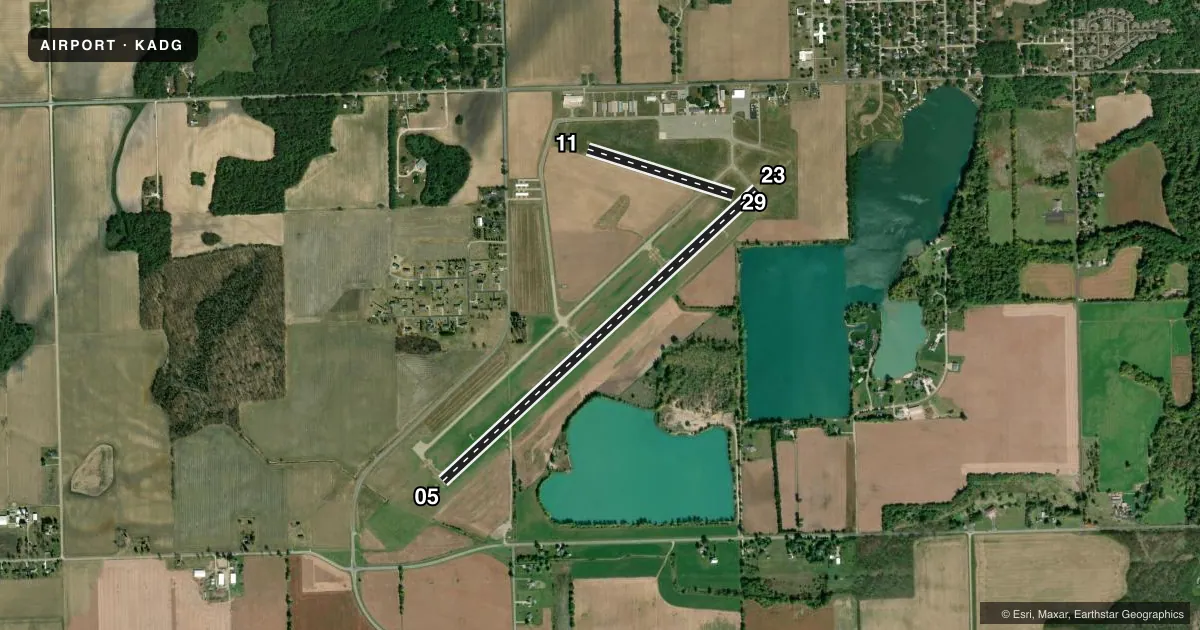
Runways & pattern
Full pagePattern entry · RWY 23
LEFT TRAFFIC| Runway | Heading (°M) | Length | Surface | Traffic |
|---|---|---|---|---|
| 05/23Favored | 41° / 221° | 5,001 ft | ASPH | Standard L |
| 11/29 | 101° / 281° | 1,779 ft | TURF | Standard L |
Runway end performance
| End | TORA | TODA | ASDA | LDA | VGSI | Approach lights | Obstruction |
|---|---|---|---|---|---|---|---|
| 05 | — | — | — | — | PAPI 4-box left(3°) | — | 49', tree, 1125' from thr, 535' R of cntrln, slope 18 |
| 23 | — | — | — | — | PAPI 4-box left(3°) | — | 49', tree, 923' from thr, 593' R of cntrln, slope 14 |
| 11 | — | — | — | — | — | — | 103', tree, 2053' from thr, 145' R of cntrln, slope 19 |
Declared distances in feet. TORA = takeoff run available, TODA = takeoff distance, ASDA = accelerate-stop, LDA = landing distance.
Airport sketch
Runways drawn to scale from FAA survey coordinates, rendered over satellite imagery. Not for navigation.
Approaches & charts
Services on the field
Fuel grades, oxygen, maintenance, ramp storage and lighting — as declared to the FAA by the airport operator.
Fuel & services
- Fuel
- 100LLA+
- Airframe repair
- Major
- Power plant repair
- Major
- Other services
- AVNCS,CHTR,GLD,INSTR
Ramp & ground
- Transient storage
- Tie-down
- Hangar
- Landing fee
- No fee published
- Customs
- Not available
- Lighting schedule
- SEE RMK
- Beacon schedule
- SS-SR
- Beacon
- White / Green (civil land)(WG)
- Wind indicator
- Lighted
- Segmented circle
- Yes
Fuel & FBOs
Cheapest 100LL and Jet A on the field and nearby. Always confirm with the FBO before taxi.
Airport notes
Surface conditions, obstructions, local procedures, lighting outages and other notes published with each FAA cycle.
General notes
- SNOW REMOVAL RWY 05/23 & TWYS ONLY.
- TAXI ON HARD SFCS ONLY DURG SPRING THAW & WET CONDTIONS.
- EXTSV GLDR OPS APR-OCT.
- CTC CG OPS ON 156.8/381.8/2182.0/2687.0/5696.0.
- FOR CD CTC TOLEDO APCH AT 419-865-1495.
Lighting notes
- ACTVT OR INCR INTST REIL RWY 05; PAPI RWY 05 & 23; HIRL RWY 05/23 - CTAF. HIRL RWY 05/23 PRESET LOW INTST.
Fuel notes
- 100LL100LL AVBL H24 SELF SVC VIA CREDIT CARD.
Runway surface & condition
- 11/29CLSD DEC-APR & WHEN SNOW COVD EXC FOR SKI EQUIPPED ACFT. NO SNOW REMOVAL.
Approach & departure obstructions
- 11YELLOW CONES.
- 29YELLOW CONES.
Other notes
- LDG FEE FOR COML ACFT WAIVED WITH MNM FUEL PURCHASE.
- FOR INTMT HNGR AVBLTY CALL AMGR.
- 2FOR SVC CALL AMGR AT 517-260-1745.
- 1UNATNDD MAJOR HOLS.
VFR map & nearby airports
VFR sectional. Tap any ICAO chip to open that airport.
Key facts · KADG
Answer card- ICAO
- KADG
- Name
- LENAWEE COUNTY
- Location
- ADRIAN, MICHIGAN
- Elevation
- 802.2 ft MSL
- Traffic pattern altitude
- 1,802.2 ft MSL (1,000 AGL)
- Control tower
- Non-towered (use CTAF)
- Total runways
- 2
- Longest runway
- 05/23 · 5,001 ft
- Published ILS approaches
- 0
- Published frequencies
- 4
- Magnetic variation
- 6°
- Current flight rules
- VFR
- Current wind
- 240° at 7 kt
- Favored runway now
- RWY 23
Lenawee County Airport sits in Adrian, Michigan. The field elevation is 802.2 ft MSL. It has two runways. The longest is 5,001 ft on 05/23. The airport is unattended on major holidays. Runway 11/29 is closed from December through April and whenever it is snow covered, except for ski equipped aircraft. No snow removal is provided for that turf runway. Snow removal is provided for runway 05/23 and the taxiways only.
There is no control tower. CTAF and UNICOM are both 122.8. The published approach frequencies are Toledo Approach 134.35 and 317.55. No ILS approaches are published. The pattern altitude is not published, so use the standard 1,000 ft AGL pattern unless current local guidance says otherwise. The on-field FBO is Lenawee County Airport. It carries 100LL and Jet A with Prist. 100LL is available 24 hours self service by credit card. For service, call the airport manager. For clearance delivery, contact Toledo Approach.
A few field details matter here. Yellow cones mark the end of runway 11. Runway lights on 05/23 are activated on CTAF. High intensity lights on 05/23 are preset to low intensity. Extensive glider operations occur from April through October. Taxi on hard surfaces only during spring thaw and wet conditions.