METAR & TAF KUSE
Current METAR
Observed 18:15Z
KUSE 271815Z AUTO 24012KT 10SM CLR 28/22 A2980 RMK AO2
- Wind
- 240° @ 12 kt
- Visibility
- 10 SM
- Temp / Dew
- 28°C / 22°C
- Altimeter
- 29.80 inHg
- Clouds
- CLR
- Density alt
- 2,677 ft
- Ceiling
- Unlimited
- Rules
- VFR
Airport info & contacts
Manager on record, flight service, ARTCC, attendance schedule and pattern altitude — published by the FAA and refreshed every 28 days.
Location
- From city
- 4 NM N
- VFR sectional
- DETROIT
- ARTCC
- ZOB · CLEVELAND
- NOTAM facility
- USE (NOTAM-D)
Airport manager
- Name
- MASON MARCONI
- Phone
- 419-335-3993
- Address
- 9460 COUNTY ROAD 14, WAUSEON OH 43567-9670
Flight service · Hours
- FSS CLE
- CLEVELAND1-800-WX-BRIEF
- Attendance
- MON-FRI · 0900-1700
Frequencies
Tap any row to copy the frequency to your clipboard.
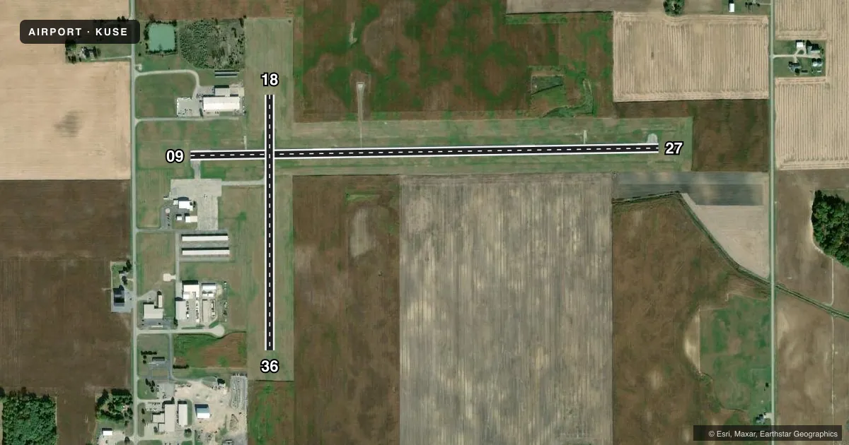
Runways & pattern
Full pagePattern entry · RWY 27
LEFT TRAFFIC| Runway | Heading (°M) | Length | Surface | Traffic |
|---|---|---|---|---|
| 09/27Favored | 84° / 264° | 3,882 ft | ASPH | Standard L |
| 18/36 | 175° / 355° | 2,115 ft | ASPH-TURF | Standard L |
Runway end performance
| End | TORA | TODA | ASDA | LDA | VGSI | Approach lights | Obstruction |
|---|---|---|---|---|---|---|---|
| 09 | — | — | — | — | PAPI 4-box left(3°) | — | 15', road, 457' from thr, 0' R of cntrln, slope 17 |
| 27 | — | — | — | — | PAPI 4-box right(3°) | — | — |
| 36 | — | — | — | — | — | — | 66', tree, 1161' from thr, 229' R of cntrln, slope 17 |
Declared distances in feet. TORA = takeoff run available, TODA = takeoff distance, ASDA = accelerate-stop, LDA = landing distance.
Airport sketch
Runways drawn to scale from FAA survey coordinates, rendered over satellite imagery. Not for navigation.
Approaches & charts
Services on the field
Fuel grades, oxygen, maintenance, ramp storage and lighting — as declared to the FAA by the airport operator.
Fuel & services
- Fuel
- 100LLA+UL94
- Oxygen (bottled)
- Not available
- Oxygen (bulk)
- Not available
- Airframe repair
- Not available
- Power plant repair
- Not available
- Other services
- AMB,INSTR
Ramp & ground
- Transient storage
- Tie-down
- Hangar
- Landing fee
- No fee published
- Customs
- Not available
- Lighting schedule
- SEE RMK
- Beacon schedule
- SS-SR
- Beacon
- White / Green (civil land)(WG)
- Wind indicator
- Yes
- Segmented circle
- No
Fuel & FBOs
Cheapest 100LL and Jet A on the field and nearby. Always confirm with the FBO before taxi.
Airport notes
Surface conditions, obstructions, local procedures, lighting outages and other notes published with each FAA cycle.
General notes
- DEER & BIRDS ON & INVOF ARPT.
- RESTROOM ACCESS, UNICOM.
- FOR CD CTC TOLEDO APCH AT 419-865-1495.
- RWY 27 CLIMB STRAIGHT OUT TO 1300 MSL.
Lighting notes
- ACTVT REIL RWY 09 & 27; PAPI RWY 09 & 27; MIRL RWY 09/27 - CTAF.
Fuel notes
- 100LL100LL & UL94 AVBL H24 SELF SVC VIA CREDIT CARD.
Approach & departure obstructions
- 18TURF PTN MKD WITH WHITE CONES.
- 36TURF PTN MKD WITH WHITE CONES.
Other notes
- PRIOR CDN RQRD.
- TIEDOWN ROPES NOT PRVDD.
- 1FOR SVC AFT HRS CALL AMGR.
- 18/36359 FT OF CNTR SECTION ASPH, NORTH 270 FT TURF, SOUTH 1328 FT TURF.
VFR map & nearby airports
VFR sectional. Tap any ICAO chip to open that airport.
Key facts · KUSE
Answer card- ICAO
- KUSE
- Name
- FULTON COUNTY
- Location
- WAUSEON, OHIO
- Elevation
- 780.8 ft MSL
- Traffic pattern altitude
- 1,780.8 ft MSL (1,000 AGL)
- Control tower
- Non-towered (use CTAF)
- Total runways
- 2
- Longest runway
- 09/27 · 3,882 ft
- Published ILS approaches
- 0
- Published frequencies
- 4
- Magnetic variation
- 5°
- Current flight rules
- VFR
- Current wind
- 240° at 12 kt
- Favored runway now
- RWY 27
Fulton County Airport sits in Wauseon, Ohio. The field elevation is 780.8 ft MSL. It has 2 runways. The longest is runway 09/27 at 3,882 ft. There is no control tower. Clearance delivery goes through Toledo Approach. The published approach frequencies are 134.35 and 317.55 MHz. No ILS approaches are published here.
Pattern altitude is not published. Use standard 1,000 ft AGL for light piston operations unless the current Chart Supplement says otherwise. Runway 09/27 has runway end identifier lights, PAPI and medium intensity runway lights that are controlled on CTAF. Runway 18/36 is a mixed surface strip with an asphalt center section and turf on the ends. The turf portions are marked with white cones.
Fulton County Airport carries AVGAS 100LL, UL94 and Jet A Prist through the on-field Fulton County Airport FBO. Fuel is available 24 hours self-service by credit card. Tiedown ropes are not provided. Restroom access is available via UNICOM. Deer and birds are reported on and near the airport, so keep a sharp scan on departure and arrival. Runway 27 has a published climb straight out to 1,300 ft MSL. Prior coordination is required. For after-hours service, call the airport manager.