METAR & TAF KTOL
Current METAR
Observed 19:52Z
KTOL 271952Z 23006KT 10SM CLR 28/20 A2982 RMK AO2 LTG DSNT W SLP094 T02830200 $
- Wind
- 230° @ 6 kt
- Visibility
- 10 SM
- Temp / Dew
- 28°C / 20°C
- Altimeter
- 29.82 inHg
- Clouds
- CLR
- Density alt
- 2,532 ft
- Ceiling
- Unlimited
- Rules
- VFR
Airport info & contacts
Manager on record, flight service, ARTCC, attendance schedule and pattern altitude — published by the FAA and refreshed every 28 days.
Location
- From city
- 10 NM SW
- VFR sectional
- DETROIT
- ARTCC
- ZOB · CLEVELAND
- NOTAM facility
- TOL (NOTAM-D)
Airport manager
- Name
- CHRIS CURRY
- Phone
- 567-703-8631
- Address
- 11013 AIRPORT HWY, SWANTON OH 43558-9321
Flight service · Hours
- FSS CLE
- CLEVELAND1-800-WX-BRIEF
- Attendance
- ALL
Frequencies
Tap any row to copy the frequency to your clipboard.
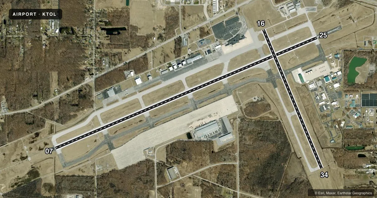
Runways & pattern
Full pagePattern entry · RWY 25
LEFT TRAFFIC| Runway | Heading (°M) | Length | Surface | Traffic |
|---|---|---|---|---|
| 07/25Favored | 62° / 242° | 10,600 ft | ASPH | Standard L |
| 16/34 | 152° / 332° | 5,599 ft | ASPH | Standard L |
Runway end performance
| End | TORA | TODA | ASDA | LDA | VGSI | Approach lights | Obstruction |
|---|---|---|---|---|---|---|---|
| 07 | 10,599' | 10,599' | 10,599' | 10,599' | — | ALSF2 | 91', trees, 4400' from thr, 1000' R of cntrln, slope 46 |
| 25 | 10,599' | 10,599' | 10,599' | 10,599' | PAPI 4-box left(3°) | MALSR | 75', trees, 2600' from thr, 760' R of cntrln, slope 32 |
| 16 | 5,599' | 5,599' | 5,599' | 5,599' | PAPI 4-box left(3°) | — | 95', trees, 2740' from thr, 40' R of cntrln, slope 26 |
| 34 | 5,599' | 5,599' | 5,599' | 5,599' | PAPI 4-box left(3°) | — | — |
Declared distances in feet. TORA = takeoff run available, TODA = takeoff distance, ASDA = accelerate-stop, LDA = landing distance.
Airport sketch
Runways drawn to scale from FAA survey coordinates, rendered over satellite imagery. Not for navigation.
Approaches & charts
ILS · 2
Services on the field
Fuel grades, oxygen, maintenance, ramp storage and lighting — as declared to the FAA by the airport operator.
Fuel & services
- Fuel
- 100LLAA++
- Oxygen (bottled)
- High pressure
- Oxygen (bulk)
- Not available
- Airframe repair
- Major
- Power plant repair
- Major
- Other services
- AFRT,AVNCS,CARGO,CHTR,INSTR,RNTL
Ramp & ground
- Transient storage
- Tie-down
- Hangar
- Landing fee
- Yes
- Customs
- Not available
- Lighting schedule
- SS-SR
- Beacon schedule
- SS-SR
- Beacon
- White / Green (civil land)(WG)
- Wind indicator
- Lighted
- Segmented circle
- No
Fuel & FBOs
Cheapest 100LL and Jet A on the field and nearby. Always confirm with the FBO before taxi.
Airport notes
Surface conditions, obstructions, local procedures, lighting outages and other notes published with each FAA cycle.
General notes
- CUST: SAT-SUN REQ MUST BE MADE BFR 1700 FRI - CALL 419-732-4446.
- BIRDS ON & INVOF ARPT.
- TWY N3 & RAMP BTN TWY B9 & B13 NOT VSB FM ATCT.
- MILITARY: ANG: PPR - OFFL BUS, ACFT WITH WINGSPANS GTR THAN 75 FT CAN EXP PRKG ON TWY D OR THE SOUTH CARGO RAMP, CTC AIRFIELD OPS DSN 580-4084/4036, C800-495-4250 EXTN 868-4084/868-4036 OR 180.FW.AIRFIELD.MANAGEMENT@US.AF.MIL. 180TH COMMAND POST H24 DSN 580-4035. ALL INBD TSNT ACFT CTC COMMAND POST.
- MILITARY: ANG: TWY D INT TWY D1, HVY ACFT USE MNM PWR TO RDC FOD ON ANG RAMP; FOR QNS CTC COMMAND POST OR AIRFIELD OPS ON 338.15.
- ATIS RECEPTION INTMT 270-320 DEGS, BYD 35 NM.
- MILITARY: ANG: AIRFIELD MGMT DOES NOT ISSUE/STORE COMSEC; FOR COMSEC STORAGE CTC COMMAND POST DSN 580-4035.
- MILITARY: ANG: BIRD HAZ WILDLIFE ACT DURG MIGRATION; BASH PHASE II IN EFF MAR-MAY & AUG-OCT. NSTD BLACK/YELLOW EQPT TOOL BOX LCTN PAINTED ON ANG RAMP.
Runway surface & condition
- 07/25PCR VALUE: 480/F/C/X/T
- 16/34PCR VALUE: 340/F/C/X/T
Approach & departure obstructions
- 25PAPI UNUSBL BYD 8 DEGS RIGHT OF CNTRLN.
Arresting gear
- 07_BAK-12BBAK-14 BAK-12B(B) (1500 FT).
- 25_BAK-12BBAK-14 BAK-12B(B) (1050 FT).
Other notes
- 48 HR PPR FOR UNSKED ACR OPS GTR THAN 10 PAX SEATS - CALL AMGR.
VFR map & nearby airports
VFR sectional. Tap any ICAO chip to open that airport.
Key facts · KTOL
Answer card- ICAO
- KTOL
- Name
- EUGENE F KRANZ TOLEDO EXPRESS
- Location
- TOLEDO, OHIO
- Elevation
- 683.9 ft MSL
- Traffic pattern altitude
- 1,683.9 ft MSL (1,000 AGL)
- Control tower
- Towered · 24
- Total runways
- 2
- Longest runway
- 07/25 · 10,600 ft
- Published ILS approaches
- 2
- Published frequencies
- 20
- Magnetic variation
- 5°
- Current flight rules
- VFR
- Current wind
- 230° at 6 kt
- Favored runway now
- RWY 25
Eugene F Kranz Toledo Express is in Toledo, Ohio. Field elevation is 683.9 ft MSL. KTOL has two asphalt runways. The longest is 10,600 ft on 07/25. The field is towered 24 hours. Two ILS approaches are published. They serve runway ends 07 and 25. Pattern altitude is not published, so use 1,000 ft AGL for light piston operations unless ATC or the current FAA Chart Supplement says otherwise.
This is a busy controlled field with military activity on the airfield. Expect to stay sharp on taxi instructions. Birds are reported on and near the airport. Migration periods bring extra wildlife activity. Taxiway N3 and the ramp between taxiways B9 and B13 are not visible from the tower. ATIS reception can be intermittent far out in some sectors, so get the latest weather before you get close.
Two on-field FBOs are listed. TOL Aviation carries 100LL, Jet A and Jet A Prist. Grand Aire carries 100LL, Jet A and Jet A Prist. For larger unscheduled aircraft, a 48-hour prior permission request is required when the operation is over 10 passenger seats. Military aircraft and some transient operations have extra permission and contact requirements. Check the current FAA Chart Supplement and coordinate with the airport operator or the FBO directly by phone before arrival if your operation is outside the normal transient flow.