METAR & TAF 1G0
1G0 does not publish a METAR.
Showing the nearest reporting station: KTDZ (TOLEDO EXEC) · 12.4 NM away. Conditions at 1G0 may differ.
METAR · KTDZ
Observed 16:53Z
KTDZ 271653Z AUTO 24013KT 10SM CLR 28/21 A2984 RMK AO2 SLP101 T02830211
- Wind
- 240° @ 13 kt
- Visibility
- 10 SM
- Temp / Dew
- 28°C / 21°C
- Altimeter
- 29.84 inHg
- Clouds
- CLR
- Density alt
- 2,494 ft
- Ceiling
- Unlimited
- Rules
- VFR
Airport info & contacts
Manager on record, flight service, ARTCC, attendance schedule and pattern altitude — published by the FAA and refreshed every 28 days.
Location
- From city
- 1 NM NE
- VFR sectional
- DETROIT
- Pattern altitude
- 1,027 ft AGL · 1,700 ft MSL
- ARTCC
- ZOB · CLEVELAND
- NOTAM facility
- 1G0 (NOTAM-D)
Airport manager
- Name
- PATRICK OREM
- Phone
- 419-354-2908
- Address
- 1261 E POE RD, BOWLING GREEN OH 43402-9392
Flight service · Hours
- FSS CLE
- CLEVELAND1-800-WX-BRIEF
- Attendance
- MON-SAT · 0800-1700
- SUN · 0800-1600
Frequencies
Tap any row to copy the frequency to your clipboard.
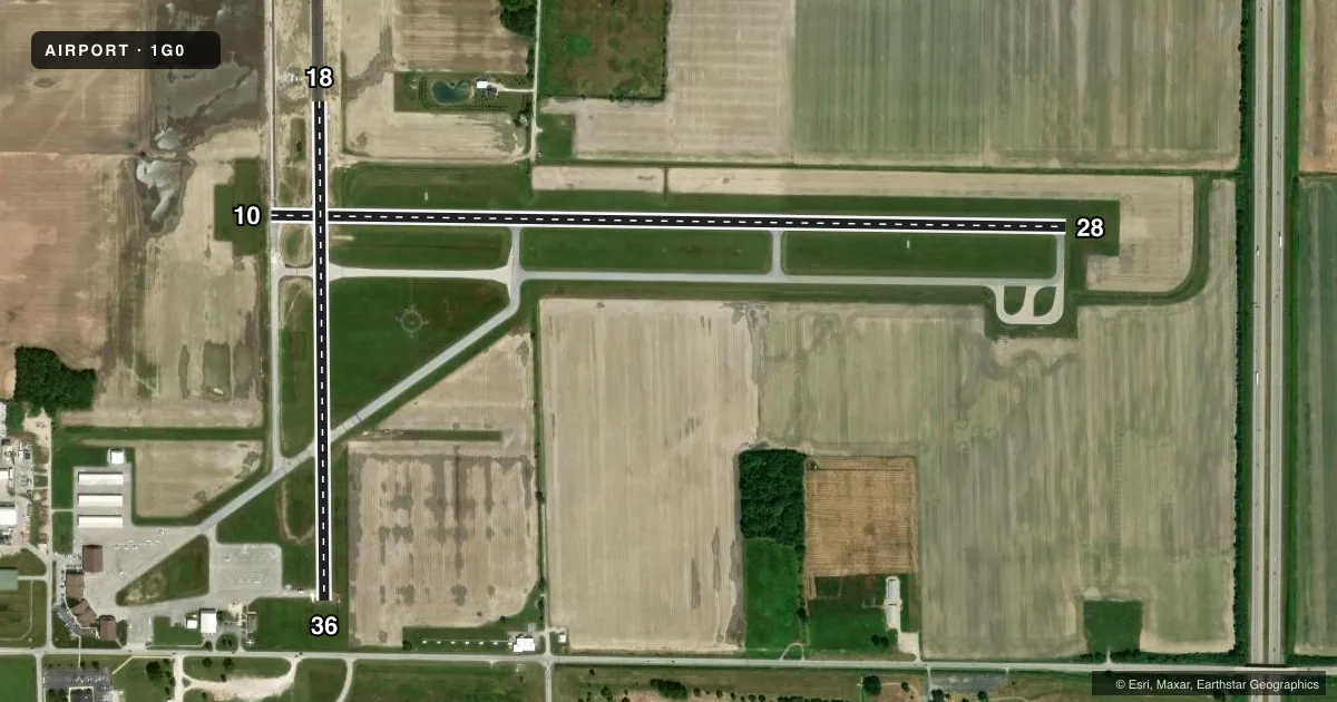
Runways & pattern
Full pagePattern entry · RWY 28
RIGHT TRAFFIC| Runway | Heading (°M) | Length | Surface | Traffic |
|---|---|---|---|---|
| 10/28Favored | 86° / 266° | 4,199 ft | ASPH | 28 R |
| 18/36 | 174° / 354° | 2,628 ft | ASPH | 36 R |
Runway end performance
| End | TORA | TODA | ASDA | LDA | VGSI | Approach lights | Obstruction |
|---|---|---|---|---|---|---|---|
| 10 | — | — | — | — | PAPI 2-box left(3°) | — | 3', crops, 201' from thr, 165' R of cntrln, slope 0 |
| 28 | — | — | — | — | PAPI 2-box left(3°) | — | 3', crops, 201' from thr, 150' R of cntrln, slope 0 |
| 18 | — | — | — | — | PAPI 4-box left(3°) | — | 3', crops, 201' from thr, 140' R of cntrln, slope 0 |
| 36 | — | — | — | — | — | — | 16', road, 270' from thr, 260' R of cntrln, slope 4 |
Declared distances in feet. TORA = takeoff run available, TODA = takeoff distance, ASDA = accelerate-stop, LDA = landing distance.
Airport sketch
Runways drawn to scale from FAA survey coordinates, rendered over satellite imagery. Not for navigation.
Approaches & charts
Services on the field
Fuel grades, oxygen, maintenance, ramp storage and lighting — as declared to the FAA by the airport operator.
Fuel & services
- Fuel
- 100LLA+
- Other services
- INSTR
Ramp & ground
- Transient storage
- Tie-down
- Hangar
- Landing fee
- No fee published
- Customs
- Not available
- Lighting schedule
- SEE RMK
- Beacon schedule
- SS-SR
- Beacon
- White / Green (civil land)(WG)
- Wind indicator
- Lighted
- Segmented circle
- Yes
Fuel & FBOs
Cheapest 100LL and Jet A on the field and nearby. Always confirm with the FBO before taxi.
Airport notes
Surface conditions, obstructions, local procedures, lighting outages and other notes published with each FAA cycle.
General notes
- OCNL BIRDS & OTR WILDLIFE ON & INVOF ARPT.
- 160 FT AGL STADIUM LGTS 0.6 NM SE OF ARPT.
- FOR CD CTC TOLEDO APCH AT 419-865-1495.
Lighting notes
- ACTVT REIL RWY 18, 10, & 28; MIRL RWY 10/28 & 18/36 - CTAF. PAPI RWY 18, 10, & 28 OPR CONSLY.
Approach & departure obstructions
- 10OBSTN CLNC SLP 0:1 DUE TO +3 FT CROPS/CULTIVATED FLD, 75-200 FT DIST, 165 FT R.
- 18OBSTN CLNC SLP 0:1 DUE TO +3 FT CROPS/CULTIVATED FLD, 0-200 FT DIST, 140 FT L & 150 FT R.
- 28OBSTN CLNC SLP 0:1 DUE TO +3 FT CROPS/CULTIVATED FLD, 0-200 FT DIST, 150 FT R; 145-200 FT DIST, 150 FT R.
- 36OBSTN CLNC SLP 0:1 DUE TO +3 FT CROPS/CULTIVATED FLD, 0-200 FT DIST, 140 FT R.
- 28CALM WIND RWY.
- 10OBSTN CLNC SLP 0:1 DUE TO +3 FT CROPS/CULTIVATED FLD, 201 FT DIST, 165 FT R & 230 FT L.
- 18OBSTN CLNC SLP 0:1 DUE TO +3 FT CROPS/CULTIVATED FLD, 201 FT DIST, 140 FT L & 150 FT R.
- 28OBSTN CLNC SLP 0:1 DUE TO +3 FT CROPS/CULTIVATED FLD, 201 FT DIST, 150 FT L/R.
- 36OBSTN CLNC SLP 4:1 TO THR DUE TO +16 FT ROAD, 270 FT DIST, 260 FT L/R; 20:1 TO DTHR.
Other notes
- PRIOR CDN RQRD FOR HNGR.
- MANAGERPATRICK@WOODCOUNTYAIRPORT.US.
- MANAGEROR 419-654-6623.
VFR map & nearby airports
VFR sectional. Tap any ICAO chip to open that airport.
Key facts · 1G0
Answer card- ICAO
- 1G0
- Name
- WOOD COUNTY RGNL
- Location
- BOWLING GREEN, OHIO
- Elevation
- 673 ft MSL
- Traffic pattern altitude
- 1,700 ft MSL (1,027 AGL)
- Control tower
- Non-towered (use CTAF)
- Total runways
- 2
- Longest runway
- 10/28 · 4,199 ft
- Published ILS approaches
- 0
- Published frequencies
- 5
- Magnetic variation
- 5°
- Current flight rules
- VFR
- Current wind
- 240° at 13 kt
- Favored runway now
- RWY 28
Wood County Airport sits in Bowling Green, Ohio. The field elevation is 673 ft MSL. It has two asphalt runways. The longest is runway 10/28 at 4,199 ft. There is no control tower. Pattern altitude is 1,027 ft AGL, or 1,700 ft MSL.
No ILS approaches are published here. For clearance delivery, contact Toledo Approach. The published remarks also call out obstacle clearance issues near the runway edges on 10, 18 and 28 due to crops and cultivated fields. That matters on short final and in the flare. Runway 28 is listed as a calm wind runway. Runway end identifier lights are installed on 18, 10 and 28. Medium intensity runway lights are on both runways and are controlled by CTAF. PAPI is operating continuously on 18, 10 and 28.
Wood County Regional Airport is on the field. It carries 100LL and Jet A with Prist. If you need hangar space, prior coordination is required. The airport also notes occasional birds and other wildlife in the area. Stadium lights 160 ft AGL sit 0.6 NM southeast of the airport. If you are new to the field, plan for a non-towered pattern. Watch the runway edge obstructions. Verify current procedures with the airport operator or the current FAA Chart Supplement before you go.