METAR & TAF 6D7
6D7 does not publish a METAR.
Showing the nearest reporting station: KOWX (PUTNAM COUNTY) · 11.9 NM away. Conditions at 6D7 may differ.
METAR · KOWX
Observed 08:15Z
KOWX 270815Z AUTO 23003KT 4SM BR OVC080 21/21 A2990 RMK AO2
- Wind
- 230° @ 3 kt
- Visibility
- 4 SM
- Temp / Dew
- 21°C / 21°C
- Altimeter
- 29.90 inHg
- Clouds
- OVC
- Density alt
- 1,620 ft
- Ceiling
- 8,000 ft AGL
- Rules
- MVFR
Airport info & contacts
Manager on record, flight service, ARTCC, attendance schedule and pattern altitude — published by the FAA and refreshed every 28 days.
Location
- From city
- 2 NM NE
- VFR sectional
- DETROIT
- ARTCC
- ZOB · CLEVELAND
- NOTAM facility
- CLE (NOTAM-D)
Airport manager
- Name
- GARY MYERS
- Phone
- 419-278-1353
- Address
- 1276 COUNTY ROAD D, DESHLER OH 43516-9763
Flight service · Hours
- FSS CLE
- CLEVELAND1-800-WX-BRIEF
- Attendance
- Unattended
Frequencies
Tap any row to copy the frequency to your clipboard.
Runways & pattern
Full pagePattern entry · RWY 27
LEFT TRAFFICRunway end performance
| End | TORA | TODA | ASDA | LDA | VGSI | Approach lights | Obstruction |
|---|---|---|---|---|---|---|---|
| 09 | — | — | — | — | — | — | 45', trees, 0' from thr, 100' R of cntrln, slope 0 |
| 27 | — | — | — | — | — | — | 76', trees, 0' from thr, 100' R of cntrln, slope 0 |
Declared distances in feet. TORA = takeoff run available, TODA = takeoff distance, ASDA = accelerate-stop, LDA = landing distance.
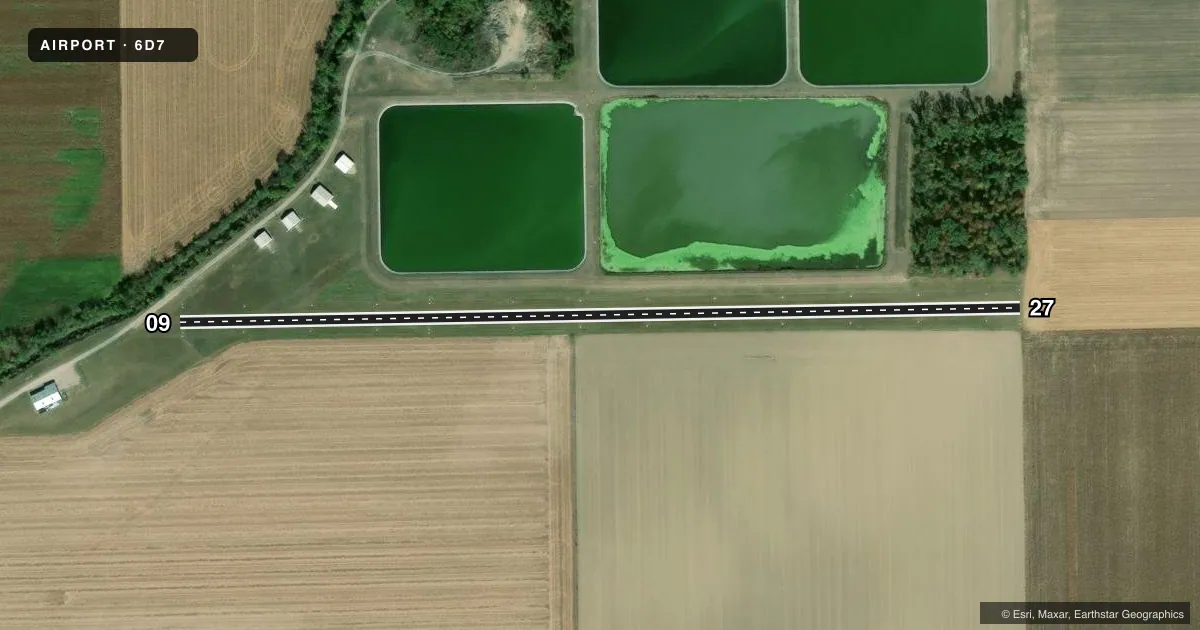
Airport sketch
Runways drawn to scale from FAA survey coordinates, rendered over satellite imagery. Not for navigation.
Approaches & charts
Services on the field
Fuel grades, oxygen, maintenance, ramp storage and lighting — as declared to the FAA by the airport operator.
Fuel & services
- Fuel
- Not available
- Oxygen (bottled)
- Not available
- Oxygen (bulk)
- Not available
- Airframe repair
- Not available
- Power plant repair
- Not available
Ramp & ground
- Transient storage
- Tie-down
- Landing fee
- No fee published
- Wind indicator
- Yes
- Segmented circle
- No
Fuel & FBOs
Cheapest 100LL and Jet A on the field and nearby. Always confirm with the FBO before taxi.
Airport notes
Surface conditions, obstructions, local procedures, lighting outages and other notes published with each FAA cycle.
General notes
- DEER, BIRDS, & WILDLIFE ON & INVOF ARPT.
- FOR CD CTC TOLEDO APCH AT 419-865-1495.
- RWY 09 40 FT TREES, 130 FT DIST, ACRS APCH.
Approach & departure obstructions
- 09DTHR MKD WITH WHITE CONES.
- 09CTLG OBSTN EXCEEDS A 45 DEG SLP.
- 27CTLG OBSTN EXCEEDS A 45 DEG SLP.
Other notes
- TIEDOWN ANCHORS & ROPES NOT PRVDD.
- MANAGERGARY.MYERS47@YAHOO.COM.
- MANAGERCELL.
- 09/27SOFT WHEN WET.
VFR map & nearby airports
VFR sectional. Tap any ICAO chip to open that airport.
Key facts · 6D7
Answer card- ICAO
- 6D7
- Name
- DESHLER MUNI LANDING STRIP
- Location
- DESHLER, OHIO
- Elevation
- 706 ft MSL
- Traffic pattern altitude
- 1,706 ft MSL (1,000 AGL)
- Control tower
- Non-towered (use CTAF)
- Total runways
- 1
- Longest runway
- 09/27 · 2,480 ft
- Published ILS approaches
- 0
- Published frequencies
- 1
- Magnetic variation
- 5°
- Current flight rules
- MVFR
- Current wind
- 230° at 3 kt
- Favored runway now
- RWY 27
Deshler Muni Landing Strip sits in Deshler, Ohio. Field elevation is 706 ft MSL. The airport has one runway. Runway 09/27 is 2,480 ft of turf, so plan for soft-field handling when the surface is wet. No tower is published, so CTAF 122.9 is the working frequency. No ILS approaches are published here.
Pattern altitude is not published. Use the standard 1,000 ft AGL pattern unless the current Chart Supplement or the airport operator gives you different guidance. That puts the light-piston pattern at 1,706 ft MSL based on the field elevation. The runway numbers are magnetic. Runway 09 has a displaced threshold marked with white cones. The published remarks also call out obstructions near both ends. Trees are listed 130 ft from the approach to runway 09. Wildlife is also a factor here. Keep a sharp scan on taxi, takeoff and landing.
There are no on-field FBOs listed. Tie-down anchors and ropes are not provided. For clearance delivery, contact Toledo Approach at 419-865-1495. If you are planning a first visit, check the current Chart Supplement for any noise or curfew restrictions before flying in. Review the runway condition before you go, since the turf runway is noted as soft when wet.