METAR & TAF KFDY
Current METAR
Observed 21:53Z
KFDY 172153Z AUTO 16007KT 9SM -RA FEW055 SCT070 OVC090 19/16 A2960 RMK AO2 SLP018 P0001 T01940156
- Wind
- 160° @ 7 kt
- Visibility
- 9 SM
- Temp / Dew
- 19°C / 16°C
- Altimeter
- 29.60 inHg
- Clouds
- OVC
- Density alt
- 1,885 ft
- Ceiling
- 9,000 ft AGL
- Rules
- VFR
Airport info & contacts
Manager on record, flight service, ARTCC, attendance schedule and pattern altitude — published by the FAA and refreshed every 28 days.
Location
- From city
- 2 NM SSW
- VFR sectional
- DETROIT
- ARTCC
- ZOB · CLEVELAND
- NOTAM facility
- FDY (NOTAM-D)
Airport manager
- Name
- AMANDA MCGEE
- Phone
- 419-422-4182
- Address
- 1205 LIMA AVE, FINDLAY OH 45840-1472
Flight service · Hours
- FSS CLE
- CLEVELAND1-800-WX-BRIEF
- Attendance
- MON-FRI · 0700-1800
- SAT-SUN · 0900-1700
Frequencies
Tap any row to copy the frequency to your clipboard.
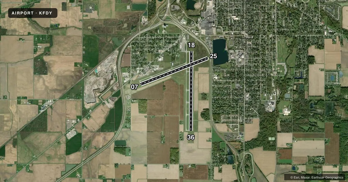
Runways & pattern
Full pagePattern entry · RWY 18
LEFT TRAFFIC| Runway | Heading (°M) | Length | Surface | Traffic |
|---|---|---|---|---|
| 18/36Favored | 175° / 355° | 6,499 ft | ASPH | Standard L |
| 07/25 | 64° / 244° | 5,883 ft | ASPH | Standard L |
Runway end performance
| End | TORA | TODA | ASDA | LDA | VGSI | Approach lights | Obstruction |
|---|---|---|---|---|---|---|---|
| 18 | — | — | — | — | PAPI 4-box left(3°) | — | — |
| 36 | — | — | — | — | PAPI 4-box left(3°) | — | — |
| 07 | 5,251' | 5,251' | 4,881' | 4,558' | PAPI 4-box left(3°) | — | 79', trees, 2350' from thr, 559' R of cntrln, slope 27 |
| 25 | 5,786' | 5,786' | 5,558' | 4,558' | PAPI 4-box left(3°) | — | 21', road, 201' from thr, 250' R of cntrln, slope 0 |
Declared distances in feet. TORA = takeoff run available, TODA = takeoff distance, ASDA = accelerate-stop, LDA = landing distance.
Airport sketch
Runways drawn to scale from FAA survey coordinates, rendered over satellite imagery. Not for navigation.
Approaches & charts
Services on the field
Fuel grades, oxygen, maintenance, ramp storage and lighting — as declared to the FAA by the airport operator.
Fuel & services
- Fuel
- 100LLA+
- Oxygen (bottled)
- Not available
- Oxygen (bulk)
- Not available
- Airframe repair
- Not available
- Power plant repair
- Not available
Ramp & ground
- Transient storage
- Tie-down
- Hangar
- Landing fee
- Yes
- Customs
- Not available
- Lighting schedule
- SEE RMK
- Beacon schedule
- SS-SR
- Beacon
- White / Green (civil land)(WG)
- Wind indicator
- Lighted
- Segmented circle
- No
Fuel & FBOs
Cheapest 100LL and Jet A on the field and nearby. Always confirm with the FBO before taxi.
Airport notes
Surface conditions, obstructions, local procedures, lighting outages and other notes published with each FAA cycle.
General notes
- FOR CD IF UNA TO CTC ON FSS FREQ, CTC TOLEDO APCH AT 419-865-1495.
- BIRDS & WILDLIFE ON & INVOF ARPT.
Lighting notes
- ACTVT REIL RWY 07, 25, & 36; PAPI RWY 07, 25, 18, & 36; MIRL RWY 07/25; HIRL RWY 18/36 - CTAF. PAPI RWY 07, 25, 18, & 36 OPR CONSLY SR-SS.
Approach & departure obstructions
- 2512 FT L/M BLAST FENCE, 117 FT DIST; 18 FT ROAD, 110 FT DIST.
- 07APCH SLP 17:1 TO DTHR OVR 65 FT TREES, 1108 FT DIST, 392 FT L.
- 25APCH SLP 34:1 TO DTHR.
Other notes
- FOR TSNT HNGR CTC FBO DRG BUS HRS.
VFR map & nearby airports
VFR sectional. Tap any ICAO chip to open that airport.
Key facts · KFDY
Answer card- ICAO
- KFDY
- Name
- FINDLAY
- Location
- FINDLAY, OHIO
- Elevation
- 812.8 ft MSL
- Traffic pattern altitude
- 1,812.8 ft MSL (1,000 AGL)
- Control tower
- Non-towered (use CTAF)
- Total runways
- 2
- Longest runway
- 18/36 · 6,499 ft
- Published ILS approaches
- 0
- Published frequencies
- 4
- Magnetic variation
- 5°
- Current flight rules
- VFR
- Current wind
- 160° at 7 kt
- Favored runway now
- RWY 18
Findlay Airport is in Findlay, Ohio. The field elevation is 812.8 ft MSL. It has two asphalt runways. The longest is runway 18/36 at 6,499 ft. There is no control tower, so use CTAF 122.725 for local traffic and UNICOM. Pattern altitude is not published. Use 1,000 ft AGL for light piston traffic unless the current Chart Supplement says otherwise.
No ILS approaches are published here. The airport does have runway lighting and PAPI on both runways. Runway 18/36 also has high intensity runway lights that are controlled on CTAF. Runway 07, 25 and 36 have runway end identifier lights. Published remarks note birds and wildlife on and near the airport. That is worth planning for on departure and arrival.
Findlay Airport has one on-field FBO. Findlay Airport carries 100LL and Jet A with Prist. Call the FBO at (419) 422-4182 before you go if you need transient hangar space. The published remarks also say to contact Toledo Approach at 419-865-1495 for clearance delivery if you cannot reach Flight Service on the usual frequency. The runway 07 approach has nearby trees. Runway 25 has a blast fence and a road close to the threshold. That makes a stabilized approach important here.