METAR & TAF 56D
56D does not publish a METAR.
Showing the nearest reporting station: KFDY (FINDLAY) · 17.8 NM away. Conditions at 56D may differ.
METAR · KFDY
Observed 01:53Z
KFDY 180153Z AUTO 19021G34KT 4SM +RA BR SCT048 BKN065 OVC110 21/18 A2947 RMK AO2 PK WND 18034/0148 SLP970 P0004 T02060183
- Wind
- 190° @ 21G34 kt
- Visibility
- 4 SM
- Temp / Dew
- 21°C / 18°C
- Altimeter
- 29.47 inHg
- Clouds
- OVC
- Density alt
- 2,307 ft
- Ceiling
- 6,500 ft AGL
- Rules
- MVFR
Airport info & contacts
Manager on record, flight service, ARTCC, attendance schedule and pattern altitude — published by the FAA and refreshed every 28 days.
Location
- From city
- 4 NM NW
- VFR sectional
- DETROIT
- ARTCC
- ZOB · CLEVELAND
- NOTAM facility
- CLE (NOTAM-D)
Airport manager
- Name
- MITCHEL GRENWALT
- Phone
- 419-294-8766
- Address
- 10841 COUNTY HIGHWAY 42, UPPER SANDUSKY OH 43351-9139
Flight service · Hours
- FSS CLE
- CLEVELAND1-800-WX-BRIEF
- Attendance
- Unattended
Frequencies
Tap any row to copy the frequency to your clipboard.
Runways & pattern
Full pagePattern entry · RWY 18
LEFT TRAFFICRunway end performance
| End | TORA | TODA | ASDA | LDA | VGSI | Approach lights | Obstruction |
|---|---|---|---|---|---|---|---|
| 18 | — | — | — | — | — | — | 55', tree, 991' from thr, 205' R of cntrln, slope 14 |
| 36 | — | — | — | — | — | — | 8', brush, 281' from thr, 117' R of cntrln, slope 10 |
Declared distances in feet. TORA = takeoff run available, TODA = takeoff distance, ASDA = accelerate-stop, LDA = landing distance.
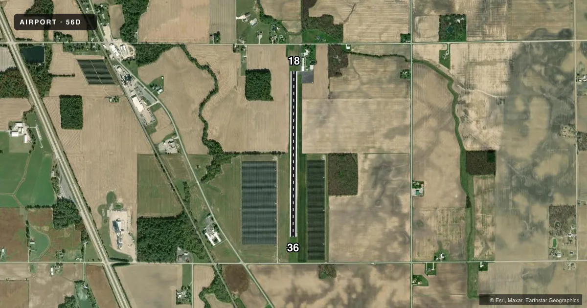
Airport sketch
Runways drawn to scale from FAA survey coordinates, rendered over satellite imagery. Not for navigation.
Approaches & charts
Services on the field
Fuel grades, oxygen, maintenance, ramp storage and lighting — as declared to the FAA by the airport operator.
Fuel & services
- Fuel
- Not available
- Oxygen (bottled)
- Not available
- Oxygen (bulk)
- Not available
- Airframe repair
- Not available
- Power plant repair
- Not available
Ramp & ground
- Transient storage
- Tie-down
- Landing fee
- No fee published
- Customs
- Not available
- Lighting schedule
- SEE RMK
- Beacon schedule
- SEE RMK
- Beacon
- White / Green (civil land)(WG)
- Wind indicator
- Lighted
- Segmented circle
- No
Fuel & FBOs
Cheapest 100LL and Jet A on the field and nearby. Always confirm with the FBO before taxi.
Airport notes
Surface conditions, obstructions, local procedures, lighting outages and other notes published with each FAA cycle.
General notes
- RWY 36 RP DUE TO +205 FT LGTD BLDG WEST OF ARPT.
- DEER, BIRDS, & OTR WILDLIFE ON & INVOF ARPT; BIRD ACT AT LANDFILL 1.5 NM NNW OF ARPT.
- FOR CD CTC CLEVELAND APCH AT 216-352-2323, WHEN APCH CLSD CTC CLEVELAND ARTCC AT 440-774-0222/0490.
Lighting notes
- ACTVT ABN - CTAF.
- ACTVT LIRL RWY 18/36 - CTAF.
Approach & departure obstructions
- 36OBST CLNC SLP 0:1 DUE TO +5-10 FT BRUSH, 0-200 FT DIST, 120 FT L; +1-7 FT BRUSH, 0-200 FT DIST, 92 FT R.
- 18CALM WIND RWY.
- 18FADED.
- 36FADED.
- 18NSTD BASIC DUE TO THR MKGS.
- 36NSTD BASIC DUE TO THR MKGS.
Other notes
- THIS AIRPORT HAS BEEN SURVEYED BY THE NATIONAL GEODETIC SURVEY.
- ROPES NOT PRVDD.
- MANAGERMGRENWALT@SCHMIDTMACHINE.COM.
- MANAGEROR 419-294-3814.
VFR map & nearby airports
VFR sectional. Tap any ICAO chip to open that airport.
Key facts · 56D
Answer card- ICAO
- 56D
- Name
- WYANDOT COUNTY
- Location
- UPPER SANDUSKY, OHIO
- Elevation
- 829.8 ft MSL
- Traffic pattern altitude
- 1,829.8 ft MSL (1,000 AGL)
- Control tower
- Non-towered (use CTAF)
- Total runways
- 1
- Longest runway
- 18/36 · 3,997 ft
- Published ILS approaches
- 0
- Published frequencies
- 4
- Magnetic variation
- 5°
- Current flight rules
- MVFR
- Current wind
- 190° at 21 kt
- Favored runway now
- RWY 18
Wyandot County Airport (56D) sits in Upper Sandusky, Ohio. Field elevation is 829.8 ft MSL. The airport has one runway, 18/36, which is 3,997 ft long and asphalt. There is no control tower. Low intensity runway lights on 18/36 are activated by CTAF. The beacon is also activated by CTAF.
No ILS approaches are published here. Pattern altitude is not published in the facts. Use the standard 1,000 ft AGL for light piston traffic unless the current FAA Chart Supplement says otherwise. Runway 36 has a displaced right pattern because of a lighted building west of the airport. Runway 36 markings are faded. It also has nonstandard basic markings due to threshold markings.
There are no on-field FBOs listed in the facts. Check with the airport operator or call the field directly before arrival for current services. Wildlife is a real factor here. Deer, birds and other wildlife are present on and near the airport. Bird activity also occurs at the landfill 1.5 NM north-northwest of the field. For clearance delivery, contact Cleveland Approach. When Approach is closed, use Cleveland ARTCC. This is a non-towered airport with published CTAF and UNICOM on 123.05. Plan ahead for local pattern and lighting procedures before you go.