METAR & TAF 17G
17G does not publish a METAR.
Showing the nearest reporting station: KMNN (MARION MUNI) · 10.7 NM away. Conditions at 17G may differ.
METAR · KMNN
Observed 19:53Z
KMNN 271953Z AUTO 24008KT 9SM CLR 28/21 A2985 RMK AO2 SLP102 T02780206
- Wind
- 240° @ 8 kt
- Visibility
- 9 SM
- Temp / Dew
- 28°C / 21°C
- Altimeter
- 29.85 inHg
- Clouds
- CLR
- Density alt
- 2,896 ft
- Ceiling
- Unlimited
- Rules
- VFR
Airport info & contacts
Manager on record, flight service, ARTCC, attendance schedule and pattern altitude — published by the FAA and refreshed every 28 days.
Location
- From city
- 1 NM S
- VFR sectional
- DETROIT
- ARTCC
- ZOB · CLEVELAND
- NOTAM facility
- CLE (NOTAM-D)
Airport manager
- Name
- KEVIN DETRAY
- Phone
- 419-562-7596
- Address
- 2254 ISAAC BEAL RD, BUCYRUS OH 44820-9692
Flight service · Hours
- FSS CLE
- CLEVELAND1-800-WX-BRIEF
- Attendance
- 0800-1700
Frequencies
Tap any row to copy the frequency to your clipboard.
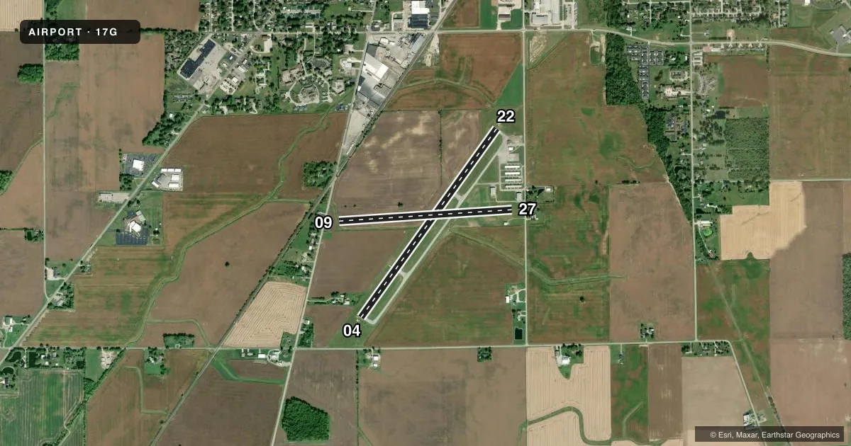
Runways & pattern
Full pagePattern entry · RWY 22
LEFT TRAFFIC| Runway | Heading (°M) | Length | Surface | Traffic |
|---|---|---|---|---|
| 04/22Favored | 29° / 209° | 3,895 ft | ASPH | Standard L |
| 09/27 | 79° / 259° | 2,902 ft | TURF | Standard L |
Runway end performance
| End | TORA | TODA | ASDA | LDA | VGSI | Approach lights | Obstruction |
|---|---|---|---|---|---|---|---|
| 04 | — | — | — | — | PAPI 2-box left(3.5°) | — | 5', crops, 201' from thr, 230' R of cntrln, slope 0 |
| 22 | — | — | — | — | PAPI 4-box left(3°) | — | 15', road, 375' from thr, 270' R of cntrln, slope 11 |
| 09 | — | — | — | — | — | — | 60', tree, 325' from thr, 20' R of cntrln, slope 5 |
| 27 | — | — | — | — | — | — | 55', tree, 275' from thr, 70' R of cntrln, slope 5 |
Declared distances in feet. TORA = takeoff run available, TODA = takeoff distance, ASDA = accelerate-stop, LDA = landing distance.
Airport sketch
Runways drawn to scale from FAA survey coordinates, rendered over satellite imagery. Not for navigation.
Approaches & charts
Services on the field
Fuel grades, oxygen, maintenance, ramp storage and lighting — as declared to the FAA by the airport operator.
Fuel & services
- Fuel
- 100LLA+
- Oxygen (bottled)
- Not available
- Oxygen (bulk)
- Not available
- Airframe repair
- Major
- Power plant repair
- Major
- Other services
- INSTR,RNTL,SALES
Ramp & ground
- Transient storage
- Tie-down
- Hangar
- Landing fee
- No fee published
- Customs
- Not available
- Lighting schedule
- SEE RMK
- Beacon schedule
- SS-SR
- Beacon
- White / Green (civil land)(WG)
- Wind indicator
- Lighted
- Segmented circle
- No
Fuel & FBOs
Cheapest 100LL and Jet A on the field and nearby. Always confirm with the FBO before taxi.
Airport notes
Surface conditions, obstructions, local procedures, lighting outages and other notes published with each FAA cycle.
General notes
- FOR CD CTC CLEVELAND APCH AT 216-352-2323, WHEN APCH CLSD CTC CLEVELAND ARTCC AT 440-774-0222/0490.
- RWY 09: -7 FT DITCH ACRS RWY END.
Lighting notes
- ACTVT WINDSOCK; WIND T; REIL RWY 04 & 22; MIRL RWY 04/22 - CTAF. PAPI RWY 04 & 22 OPR CONSLY.
Approach & departure obstructions
- 04+5 FT CROPS, 200 FT DIST FM DTHR, 230 FT L, 0:1.
- 04OBSTN CLNC SLP 0:1 TO THR OVR +5 FT CROPS, 201 FT DIST, 230 FT L; 0:1 TO DTHR OVR +5 FT CROPS, 200 FT DIST, 230 FT L.
- 09OBSTN CLNC SLP 5:1 OVR +60 FT TREE, 325 FT DIST, 20 FT R.
- 22OBSTN CLNC SLP 11:1 OVR +15 FT ROAD, 375 FT DIST, 270 FT L.
- 27OBSTN CLNC SLP 5:1 OVR +55 FT TREE, 275 FT DIST, 70 FT L.
Other notes
- PRIOR CDN RQRD FOR TSNT HNGR.
- 3UNATNDD MAJOR HOLS.
- MANAGERKNDETRAY@GMAIL.COM.
VFR map & nearby airports
VFR sectional. Tap any ICAO chip to open that airport.
Key facts · 17G
Answer card- ICAO
- 17G
- Name
- PORT BUCYRUS/CRAWFORD COUNTY
- Location
- BUCYRUS, OHIO
- Elevation
- 1,007.8 ft MSL
- Traffic pattern altitude
- 2,007.8 ft MSL (1,000 AGL)
- Control tower
- Non-towered (use CTAF)
- Total runways
- 2
- Longest runway
- 04/22 · 3,895 ft
- Published ILS approaches
- 0
- Published frequencies
- 4
- Magnetic variation
- 7°
- Current flight rules
- VFR
- Current wind
- 240° at 8 kt
- Favored runway now
- RWY 22
Port Bucyrus/Crawford County Airport (17G) sits in Bucyrus, Ohio at 1,007.8 ft MSL. It has two runways. The longest is 04/22 at 3,895 ft. Runway 09/27 is turf and measures 2,902 ft. There is no control tower. Pattern altitude is not published, so use the standard 1,000 ft AGL for light piston operations unless the current Chart Supplement says otherwise.
There are no ILS approaches published here. CTAF and UNICOM are both 122.8. Cleveland Approach handles the area on 128.35 and 360.65. DeTray Aviation is on the field. It carries 100LL and Jet A. Call ahead at (419) 562-7596 if you need current services.
The published remarks matter here. Runway 04 and 22 have lights controlled by CTAF. The windsock is activated. PAPI is on 04 and 22 and runs continuously. There are also obstructions near several runway ends, including crops near 04, a tree near 09, a road near 22 and a tree near 27. Runway 09 also has a 7-foot ditch across the end. This is a small, unattended field on major holidays. If you are planning a transient hangar, coordinate first.