METAR & TAF 8G1
8G1 does not publish a METAR.
Showing the nearest reporting station: KMFD (MANSFIELD LAHM RGNL) · 16.1 NM away. Conditions at 8G1 may differ.
METAR · KMFD
Observed 02:52Z
KMFD 270252Z AUTO 21004KT 10SM CLR 21/19 A2993 RMK AO2 SLP126 T02110189 53004 $
- Wind
- 210° @ 4 kt
- Visibility
- 10 SM
- Temp / Dew
- 21°C / 19°C
- Altimeter
- 29.93 inHg
- Clouds
- CLR
- Density alt
- 1,906 ft
- Ceiling
- Unlimited
- Rules
- VFR
Airport info & contacts
Manager on record, flight service, ARTCC, attendance schedule and pattern altitude — published by the FAA and refreshed every 28 days.
Location
- From city
- 1 NM S
- VFR sectional
- DETROIT
- ARTCC
- ZOB · CLEVELAND
- NOTAM facility
- CLE (NOTAM-D)
Airport manager
- Name
- ROB CAVELLO
- Phone
- 419-933-7531
- Address
- 631 S MYRTLE AVE, WILLARD OH 44890-1549
Flight service · Hours
- FSS CLE
- CLEVELAND1-800-WX-BRIEF
- Attendance
- Unattended
Frequencies
Tap any row to copy the frequency to your clipboard.
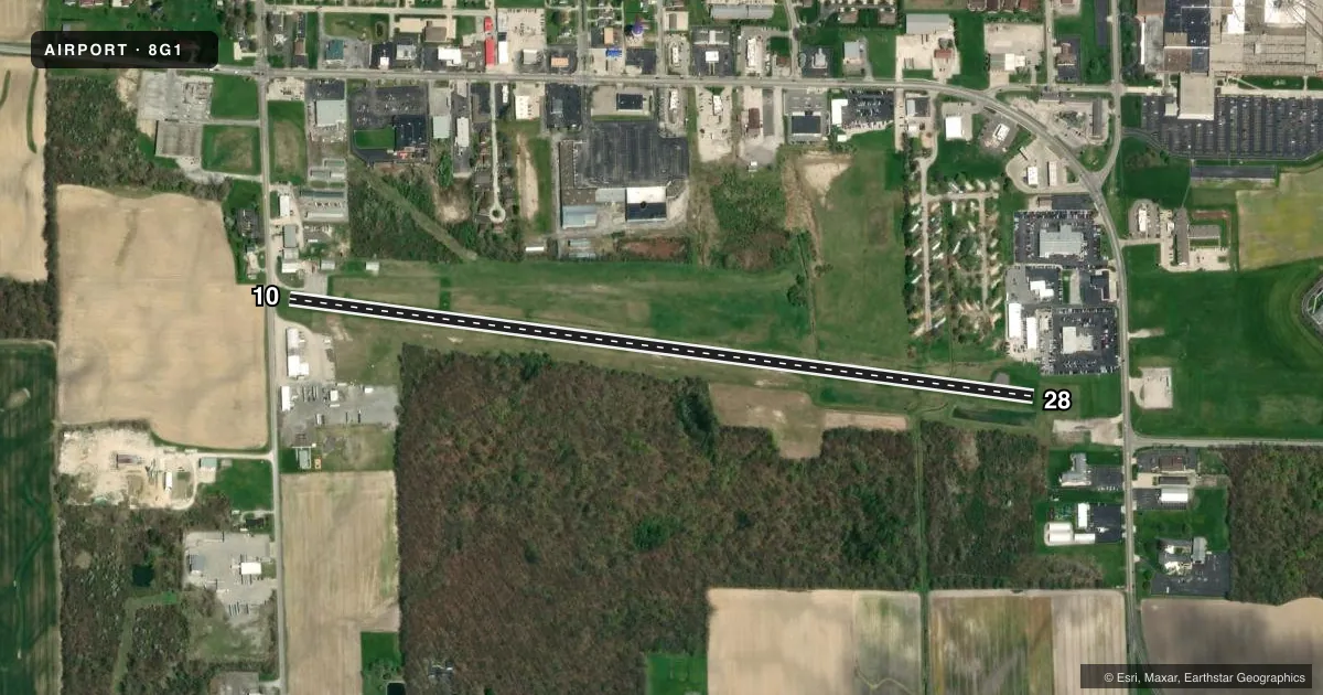
Runways & pattern
Full pagePattern entry · RWY 28
LEFT TRAFFICRunway end performance
| End | TORA | TODA | ASDA | LDA | VGSI | Approach lights | Obstruction |
|---|---|---|---|---|---|---|---|
| 10 | — | — | — | — | — | — | 12', bldg, 211' from thr, 87' R of cntrln, slope 0 |
| 28 | — | — | — | — | — | — | 100', trees, 1224' from thr, 136' R of cntrln, slope 10 |
Declared distances in feet. TORA = takeoff run available, TODA = takeoff distance, ASDA = accelerate-stop, LDA = landing distance.
Airport sketch
Runways drawn to scale from FAA survey coordinates, rendered over satellite imagery. Not for navigation.
Approaches & charts
Services on the field
Fuel grades, oxygen, maintenance, ramp storage and lighting — as declared to the FAA by the airport operator.
Fuel & services
- Fuel
- 100LL
Ramp & ground
- Transient storage
- Tie-down
- Landing fee
- No fee published
- Customs
- Not available
- Lighting schedule
- SEE RMK
- Wind indicator
- Yes
- Segmented circle
- No
Fuel & FBOs
Cheapest 100LL and Jet A on the field and nearby. Always confirm with the FBO before taxi.
Airport notes
Surface conditions, obstructions, local procedures, lighting outages and other notes published with each FAA cycle.
General notes
- FOR CD CTC CLEVELAND APCH AT 216-352-2323, WHEN APCH CLSD CTC CLEVELAND ARTCC AT 440-774-0222/0490.
- RWY 28: AUTO DEALER PRKG LOT LGTS SHINE IN RWY APCH.
- DEER, BIRDS, & OTR WILDLIFE ON & INVOF ARPT.
- HOSPITAL HELI 0.4 NM EAST OF RWY END 28.
Lighting notes
- ACTVT MIRL RWY 10/28 - CTAF.
Fuel notes
- 100LLFOR FUEL WKDAYS 0700-1500 CALL AMGR; AFT HRS CALL 419-933-2561.
Approach & departure obstructions
- 1015 FT ROAD, 75 FT DIST, 125 FT L/R; 15 FT PRKG LOT, 0-90 FT DIST, 50 FT L; 14 FT BLDG, 180 FT DIST, 100 FT L.
- 2810 FT PRKG LOT, 135-200 FT DIST, 99-105 FT R.
- 28APCH RATIO 18:1 TO DTHR.
- 10APCH RATIO 11:1 TO DTHR OVR 22 FT BLDG, 260 FT DIST, 170 FT R.
- 10ALSO 90 FT TREES, 1230 FT DSTC.
Other notes
- THIS AIRPORT HAS BEEN SURVEYED BY THE NATIONAL GEODETIC SURVEY.
- MANAGERARPT PHYS ADS: 3744 STATE ROUTE 103 S, WILLARD, OH 44890.
- MANAGERAIRPORT@WILLARDOHIO.GOV.
VFR map & nearby airports
VFR sectional. Tap any ICAO chip to open that airport.
Key facts · 8G1
Answer card- ICAO
- 8G1
- Name
- WILLARD
- Location
- WILLARD, OHIO
- Elevation
- 966.6 ft MSL
- Traffic pattern altitude
- 1,966.6 ft MSL (1,000 AGL)
- Control tower
- Non-towered (use CTAF)
- Total runways
- 1
- Longest runway
- 10/28 · 4,028 ft
- Published ILS approaches
- 0
- Published frequencies
- 3
- Magnetic variation
- 6°
- Current flight rules
- VFR
- Current wind
- 210° at 4 kt
- Favored runway now
- RWY 28
Willard Airport (8G1) sits in Willard, Ohio. Field elevation is 966.6 ft MSL. The airport has one runway. Runway 10/28 is 4,028 ft long. There is no control tower. CTAF is 122.9. Cleveland Approach handles the area on 128.35 and 360.65.
No ILS approaches are published here. Pattern altitude is not published, so a light piston pilot should plan on the standard 1,000 ft AGL unless the current FAA Chart Supplement says otherwise. That puts the traffic pattern at about 1,967 ft MSL based on the field elevation.
There is no on-field FBO listed. For fuel on weekdays from 0700 to 1500, call the airport manager. After hours, call 419-933-2561. The published remarks also call out wildlife on and near the airport, so keep a sharp scan on taxi, takeoff and landing. Runway 10 has nearby road, parking lot and building obstructions. Runway 28 has approach lighting from auto dealer parking lots. The approach clearance slopes are also published for both ends. If you are new to the field, review the current Chart Supplement before arrival. Pay close attention to the runway environment.