METAR & TAF S24
Current METAR
Observed 17:58Z
KS24 271758Z AUTO 22008G14KT 10SM FEW031 30/23 A2977 RMK AO2
- Wind
- 220° @ 8G14 kt
- Visibility
- 10 SM
- Temp / Dew
- 30°C / 23°C
- Altimeter
- 29.77 inHg
- Clouds
- FEW
- Density alt
- 2,810 ft
- Ceiling
- Unlimited
- Rules
- VFR
Airport info & contacts
Manager on record, flight service, ARTCC, attendance schedule and pattern altitude — published by the FAA and refreshed every 28 days.
Location
- From city
- 5 NM SE
- VFR sectional
- DETROIT
- ARTCC
- ZOB · CLEVELAND
- NOTAM facility
- S24 (NOTAM-D)
Airport manager
- Name
- MICHAEL RUSSELL
- Phone
- 419-547-0131
- Address
- 1500 COUNTY ROAD 220, CLYDE OH 43410-9562
Flight service · Hours
- FSS CLE
- CLEVELAND1-800-WX-BRIEF
- Attendance
- MON-SAT · 0800-1700
Frequencies
Tap any row to copy the frequency to your clipboard.
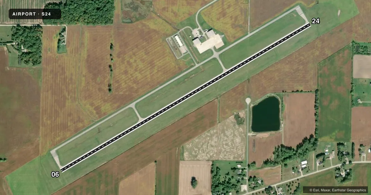
Runways & pattern
Full pagePattern entry · RWY 24
LEFT TRAFFICRunway end performance
| End | TORA | TODA | ASDA | LDA | VGSI | Approach lights | Obstruction |
|---|---|---|---|---|---|---|---|
| 06 | — | — | — | — | PAPI 4-box left(3°) | — | 85', tree, 2478' from thr, 30' R of cntrln, slope 26 |
| 24 | — | — | — | — | PAPI 4-box left(3°) | — | — |
Declared distances in feet. TORA = takeoff run available, TODA = takeoff distance, ASDA = accelerate-stop, LDA = landing distance.
Airport sketch
Runways drawn to scale from FAA survey coordinates, rendered over satellite imagery. Not for navigation.
Approaches & charts
Services on the field
Fuel grades, oxygen, maintenance, ramp storage and lighting — as declared to the FAA by the airport operator.
Fuel & services
- Fuel
- 100LLA+
- Oxygen (bottled)
- Not available
- Oxygen (bulk)
- Not available
- Airframe repair
- Not available
- Power plant repair
- Not available
- Other services
- AMB
Ramp & ground
- Transient storage
- Tie-down
- Hangar
- Landing fee
- Yes
- Lighting schedule
- SEE RMK
- Beacon schedule
- SS-SR
- Beacon
- White / Green (civil land)(WG)
- Wind indicator
- Lighted
- Segmented circle
- No
Fuel & FBOs
Cheapest 100LL and Jet A on the field and nearby. Always confirm with the FBO before taxi.
Airport notes
Surface conditions, obstructions, local procedures, lighting outages and other notes published with each FAA cycle.
General notes
- BIRDS & DEER ON & INVOF ARPT.
- FOR CD CTC TOLEDO APCH AT 419-865-1495.
Lighting notes
- ACTVT REIL RWY 06 & 24; PAPI RWY 06 & 24; MIRL RWY 06/24 - CTAF.
Fuel notes
- 100LL100LL & JET A+ AVBL H24 SELF SVC VIA CREDIT CARD.
Other notes
- THIS AIRPORT HAS BEEN SURVEYED BY THE NATIONAL GEODETIC SURVEY.
- 2UNATNDD MAJOR HOLS; AFT HRS CALL 419-547-0131.
- MANAGERMANAGER@SANDUSKYCOUNTYAIRPORT.COM.
VFR map & nearby airports
VFR sectional. Tap any ICAO chip to open that airport.
Key facts · S24
Answer card- ICAO
- S24
- Name
- SANDUSKY COUNTY RGNL
- Location
- FREMONT, OHIO
- Elevation
- 664.5 ft MSL
- Traffic pattern altitude
- 1,664.5 ft MSL (1,000 AGL)
- Control tower
- Non-towered (use CTAF)
- Total runways
- 1
- Longest runway
- 06/24 · 5,500 ft
- Published ILS approaches
- 0
- Published frequencies
- 4
- Magnetic variation
- 7°
- Current flight rules
- VFR
- Current wind
- 220° at 8 kt
- Favored runway now
- RWY 24
Sandusky County Rgnl sits in Fremont, Ohio. The field elevation is 664.5 ft MSL. It has one runway. Runway 06/24 is 5,500 ft long with asphalt pavement. There is no control tower. Pattern altitude is not published, so verify the current Chart Supplement before you go. No ILS approaches are published here.
The airport uses CTAF 123.05. UNICOM is also 123.05. Toledo Approach provides clearance delivery and approach or departure service on 126.1 and 307.0. The published remarks say runway end identifier lights are installed on 06 and 24. Precision approach path indicators are also installed on both ends. Medium intensity runway lights are on 06/24 and are controlled on CTAF.
Sandusky County Regional Airport is the on-field FBO. It carries 100LL and Jet A. Self-serve fuel is available 24 hours with a credit card. The airport is unattended on major holidays. Birds and deer are reported in the vicinity, so keep a sharp scan on arrival and departure. For a first trip in, plan for an uncontrolled field with published lighting and no ILS. If you need the latest operating details, call the airport operator or the FBO directly by phone.