METAR & TAF 14G
14G does not publish a METAR.
Showing the nearest reporting station: KPCW (ERIE-OTTAWA INTL) · 17.1 NM away. Conditions at 14G may differ.
METAR · KPCW
Observed 17:15Z
KPCW 271715Z AUTO 22010KT 200V270 10SM CLR 29/22 A2981 RMK AO2
- Wind
- 220° @ 10 kt
- Visibility
- 10 SM
- Temp / Dew
- 29°C / 22°C
- Altimeter
- 29.81 inHg
- Clouds
- CLR
- Density alt
- 2,639 ft
- Ceiling
- Unlimited
- Rules
- VFR
Airport info & contacts
Manager on record, flight service, ARTCC, attendance schedule and pattern altitude — published by the FAA and refreshed every 28 days.
Location
- From city
- 2 NM SW
- VFR sectional
- DETROIT
- ARTCC
- ZOB · CLEVELAND
- NOTAM facility
- CLE (NOTAM-D)
Airport manager
- Name
- REX DAMSCHRODER
- Phone
- 419-307-3111
- Address
- 365 S STATE ROUTE 53, FREMONT OH 43420-9668
Flight service · Hours
- FSS CLE
- CLEVELAND1-800-WX-BRIEF
- Attendance
- MON-SAT · 0900-1600
- SUN · 1200-1600
Frequencies
Tap any row to copy the frequency to your clipboard.
Runways & pattern
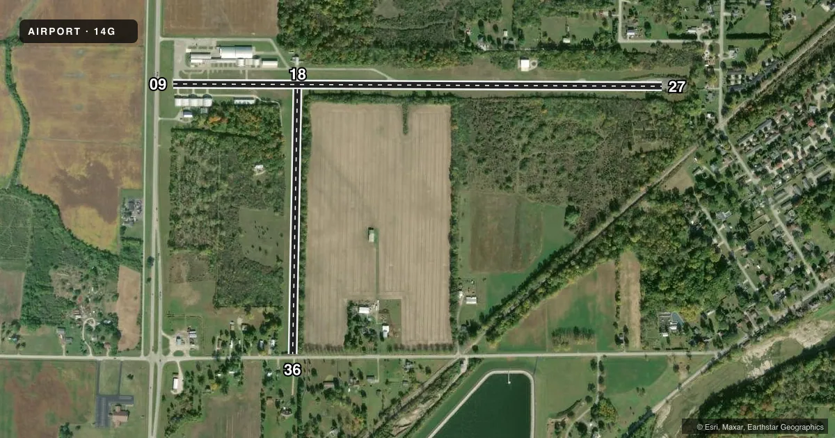
Full pagePattern entry · RWY 18
LEFT TRAFFIC| Runway | Heading (°M) | Length | Surface | Traffic |
|---|---|---|---|---|
| 09/27 | 85° / 265° | 4,137 ft | ASPH | Standard L |
| 18/36Favored | 176° / 356° | 2,238 ft | TURF | Standard L |
Runway end performance
| End | TORA | TODA | ASDA | LDA | VGSI | Approach lights | Obstruction |
|---|---|---|---|---|---|---|---|
| 09 | — | — | — | — | — | — | 16', road, 223' from thr, 125' R of cntrln, slope 1 |
| 27 | — | — | — | — | — | — | 39', trees, 293' from thr, 73' R of cntrln, slope 2 |
| 18 | — | — | — | — | — | — | 90', trees, 262' from thr, 94' R of cntrln, slope 2 |
| 36 | — | — | — | — | — | — | 60', tree, 0' from thr, 125' R of cntrln, slope 0 |
Declared distances in feet. TORA = takeoff run available, TODA = takeoff distance, ASDA = accelerate-stop, LDA = landing distance.
Airport sketch
Runways drawn to scale from FAA survey coordinates, rendered over satellite imagery. Not for navigation.
Approaches & charts
Services on the field
Fuel grades, oxygen, maintenance, ramp storage and lighting — as declared to the FAA by the airport operator.
Fuel & services
- Fuel
- 100LL
- Airframe repair
- Major
- Power plant repair
- Major
- Other services
- INSTR,RNTL,SALES
Ramp & ground
- Transient storage
- Tie-down
- Hangar
- Landing fee
- No fee published
- Customs
- Not available
- Lighting schedule
- SEE RMK
- Wind indicator
- Yes
- Segmented circle
- No
Fuel & FBOs
Cheapest 100LL and Jet A on the field and nearby. Always confirm with the FBO before taxi.
Airport notes
Surface conditions, obstructions, local procedures, lighting outages and other notes published with each FAA cycle.
General notes
- RWY 27 ONLY 3390 FT LGTD. 3900 FT PAVEMENT AVBL DALGT HRS.
- RWY 27: WHITE LN MARKS RWY END, 330 FT OF PAVEMENT EAST OF LINE FAILED & UNSUITABLE FOR ACFT DUE TO WDSPR SVR CRACKING, DSTNS OVR 3 IN, & WDSPR VEGETATION GROWTH.
- DEER & BIRDS ON & INVOF ARPT.
- FOR CD CTC TOLEDO APCH AT 419-865-1495.
- PUBLD RWY DIMENSIONS DO NOT MATCH PAVEMENT MRKGS.
Lighting notes
- ACTVT LIRL RWY 09/27 - 5 SLOW CLICKS CTAF.
Fuel notes
- 100LLAFT HRS FUEL 419-307-3111.
Runway surface & condition
- 18/36MOWED 58 FT WIDE. EAST EDGE OF RWY OBSTD BY +60 FT TREES, 50 FT FM CNTRLN, ENTR LEN OF RWY.
Approach & departure obstructions
- 0916 FT ROAD, 120 FT DIST, 250 FT L/R.
- 27+50 FT TREES, 0 FT DIST, 100 FT L; -15 FT DROP OFF EAST END. EAST 330 FT UNUSBL.
- 27RWY NR FADED.
- 09NSTD DUE TO WHITE LN MARKS RWY END & DTHR NOT MKD.
- 27NSTD DUE TO WHITE LN MARKS RWY END.
- 18THR OBSTD BY TREES.
- 18+60 TREES, 0 FT DIST, 125 FT L/R. CTLG OBSTN EXCEEDS A 45 DEG SLP.
Other notes
- THIS AIRPORT HAS BEEN SURVEYED BY THE NATIONAL GEODETIC SURVEY.
- WINDCONE FADED.
- MANAGERADNL CTC MOLLY JOHNSON 419-443-5108.
- 09/27OUTER 15 FT EACH SIDE WDSPR CRACKING, LOOSE STONES, & VEGETATION GROWTH; CNTR 30 FT FAIR COND.
VFR map & nearby airports
VFR sectional. Tap any ICAO chip to open that airport.
Key facts · 14G
Answer card- ICAO
- 14G
- Name
- FREMONT
- Location
- FREMONT, OHIO
- Elevation
- 663.2 ft MSL
- Traffic pattern altitude
- 1,663.2 ft MSL (1,000 AGL)
- Control tower
- Non-towered (use CTAF)
- Total runways
- 2
- Longest runway
- 09/27 · 4,137 ft
- Published ILS approaches
- 0
- Published frequencies
- 4
- Magnetic variation
- 5°
- Current flight rules
- VFR
- Current wind
- 220° at 10 kt
- Favored runway now
- RWY 18
Fremont Airport sits in Fremont, Ohio. Field elevation is 663.2 ft MSL. The airport has two runways. The longest is 09/27 at 4,137 ft of asphalt. There is no control tower. No ILS approaches are published. Pattern altitude is not published, so verify the current traffic pattern in the FAA Chart Supplement before you go. The field uses Toledo Approach for clearance delivery and approach support.
Rex Air is on the field. It carries 100LL. Call ahead if you need fuel after hours. The airport remarks matter here. Runway 09/27 has faded markings near 27. The outer 15 ft on each side of 09/27 show cracking, loose stones and some vegetation growth. The center 30 ft is in fair condition. Runway 18/36 is turf and is mowed 58 ft wide. Trees over 60 ft tall sit close to the east edge of 18/36. The threshold of runway 18 is also obstructed by trees. Runway 27 can be lit with five slow clicks on CTAF. Deer and birds are reported on and near the airport. Runway 27 is marked as 3,390 ft of usable pavement during daylight. Check the current field conditions before planning a short-field arrival.