METAR & TAF 3W2
3W2 does not publish a METAR.
Showing the nearest reporting station: KPCW (ERIE-OTTAWA INTL) · 7.5 NM away. Conditions at 3W2 may differ.
METAR · KPCW
Observed 20:55Z
KPCW 272055Z AUTO 26012KT 10SM CLR 27/22 A2980 RMK AO2
- Wind
- 260° @ 12 kt
- Visibility
- 10 SM
- Temp / Dew
- 27°C / 22°C
- Altimeter
- 29.80 inHg
- Clouds
- CLR
- Density alt
- 2,327 ft
- Ceiling
- Unlimited
- Rules
- VFR
Airport info & contacts
Manager on record, flight service, ARTCC, attendance schedule and pattern altitude — published by the FAA and refreshed every 28 days.
Location
- From city
- 1 NM SW
- VFR sectional
- DETROIT
- ARTCC
- ZOB · CLEVELAND
- NOTAM facility
- CLE (NOTAM-D)
Airport manager
- Name
- BETH FURNER
- Phone
- 419-285-3371
- Address
- 1494 LANGRAM RD, PUT IN BAY OH 43456-6721
Flight service · Hours
- FSS CLE
- CLEVELAND1-800-WX-BRIEF
- Attendance
- IREG
Frequencies
Tap any row to copy the frequency to your clipboard.
Runways & pattern
Full pagePattern entry · RWY 21
LEFT TRAFFICRunway end performance
| End | TORA | TODA | ASDA | LDA | VGSI | Approach lights | Obstruction |
|---|---|---|---|---|---|---|---|
| 03 | — | — | — | — | — | — | 61', trees, 402' from thr, 119' R of cntrln, slope 3 |
| 21 | — | — | — | — | — | — | 5', fence, 201' from thr, 120' R of cntrln, slope 0 |
Declared distances in feet. TORA = takeoff run available, TODA = takeoff distance, ASDA = accelerate-stop, LDA = landing distance.
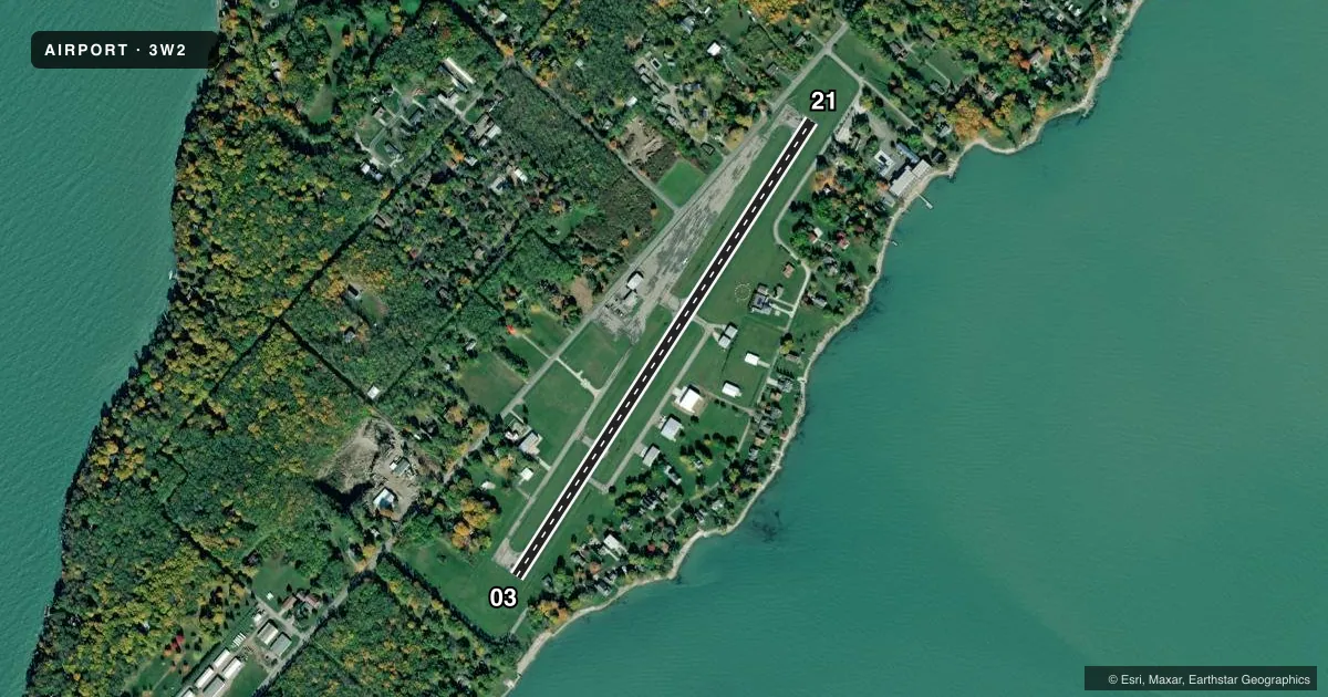
Airport sketch
Runways drawn to scale from FAA survey coordinates, rendered over satellite imagery. Not for navigation.
Approaches & charts
Services on the field
Fuel grades, oxygen, maintenance, ramp storage and lighting — as declared to the FAA by the airport operator.
Fuel & services
- Fuel
- Not available
- Oxygen (bottled)
- Not available
- Oxygen (bulk)
- Not available
- Airframe repair
- Major
- Power plant repair
- Major
- Other services
- CHTR
Ramp & ground
- Transient storage
- Tie-down
- Hangar
- Landing fee
- Yes
- Customs
- Not available
- Beacon schedule
- SS-SR
- Beacon
- White / Green (civil land)(WG)
- Wind indicator
- Yes
- Segmented circle
- Yes
Fuel & FBOs
Cheapest 100LL and Jet A on the field and nearby. Always confirm with the FBO before taxi.
Airport notes
Surface conditions, obstructions, local procedures, lighting outages and other notes published with each FAA cycle.
General notes
- EXP MOD TURB ON APCH/DEP WHEN WIND EXCEEDS 10 KT.
- ACFT LDG RWY 21 OR DEP RWY 03 RMN 1000 FT CLEAR OF PERRY'S MONUMENT 352 FT AGL (942 FT MSL) 1.3 NM NE OF ARPT.
- ACFT OPS PROHIBITED DUSK-DAWN.
- HELIPAD IS FOR TOUCHDOWN, LOADING, & LIFTOFF ONLY - PARK ON GRASS WEST & SW OF HELIPAD.
- BIRDS, DEER, & OTR WILDLIFE INVOF ARPT.
- FOR CD CTC CLEVELAND APCH AT 216-352-2323.
Approach & departure obstructions
- 03+0-5 FT FENCE, 200 FT DIST, 125 FT R, EXTDG TO 250 FT FM DTHR, 125 FT R.
- 21+5 FENCE, 0-200 FT DIST, 115 FT L; ALSO +5 FT FENCE, 140-200 FT DIST, 115-125 FT R.
- 03APCH RATIO 13:1 TO DTHR OVR +61 FT TREE, 852 FT DIST, 119 FT L.
- 21APCH RATIO 15:1 TO DTHR OVR +63 FT TREE, 1158 FT DIST, 68 FT L.
Other notes
- THIS AIRPORT HAS BEEN SURVEYED BY THE NATIONAL GEODETIC SURVEY.
- ESTABD BFR 1959.
- PRKG/RAMP FEES FOR ALL PVT & COML ACFT; ALL PILOTS ARE RQRD TO CK IN AT ARPT OFC AT TIME OF ARR; ALL ACFT RQRD TO SHUT DOWN ENGINE(S) WHEN ENPLANING/DEPLANING PAX.
- PRIOR CDN RQRD.
- ROPES NOT PRVDD.
VFR map & nearby airports
VFR sectional. Tap any ICAO chip to open that airport.
Key facts · 3W2
Answer card- ICAO
- 3W2
- Name
- PUT IN BAY
- Location
- PUT IN BAY, OHIO
- Elevation
- 595 ft MSL
- Traffic pattern altitude
- 1,595 ft MSL (1,000 AGL)
- Control tower
- Non-towered (use CTAF)
- Total runways
- 1
- Longest runway
- 03/21 · 2,870 ft
- Published ILS approaches
- 0
- Published frequencies
- 2
- Magnetic variation
- 7°
- Current flight rules
- VFR
- Current wind
- 260° at 12 kt
- Favored runway now
- RWY 21
Put In Bay Airport (3W2) sits in Put In Bay, Ohio. Field elevation is 595 ft MSL. The airport has one runway. Runway 03/21 is 2,870 ft of asphalt, which is the longest runway on the field. There is no control tower. CTAF and UNICOM are both 122.8. No ILS approaches are published.
Pattern altitude is not published. Use the standard 1,000 ft AGL pattern unless the current FAA Chart Supplement or the airport operator tells you otherwise. With the field at 595 ft MSL, that is 1,595 ft MSL for a standard light piston pattern. Aircraft operations are prohibited from dusk to dawn. That matters here. Plan daylight only.
The published remarks also call out a few items that matter on a first visit. Approach to runway 21 has tree and fence obstructions near the threshold. Perry’s Monument is also a factor on runway 21 arrivals and runway 03 departures. Expect moderate turbulence when wind exceeds 10 knots. Wildlife is in the area too. Prior coordination is required. Parking and ramp fees apply. Pilots must check in at the airport office on arrival. Engines must be shut down while passengers load or unload. No on-field FBOs are listed, so verify current services with the airport operator or the FBO directly by phone before you go.