METAR & TAF 3T7
3T7 does not publish a METAR.
Showing the nearest reporting station: KPCW (ERIE-OTTAWA INTL) · 10.7 NM away. Conditions at 3T7 may differ.
METAR · KPCW
Observed 20:55Z
KPCW 272055Z AUTO 26012KT 10SM CLR 27/22 A2980 RMK AO2
- Wind
- 260° @ 12 kt
- Visibility
- 10 SM
- Temp / Dew
- 27°C / 22°C
- Altimeter
- 29.80 inHg
- Clouds
- CLR
- Density alt
- 2,307 ft
- Ceiling
- Unlimited
- Rules
- VFR
Airport info & contacts
Manager on record, flight service, ARTCC, attendance schedule and pattern altitude — published by the FAA and refreshed every 28 days.
Location
- From city
- 1 NM NE
- VFR sectional
- DETROIT
- ARTCC
- ZOB · CLEVELAND
- NOTAM facility
- CLE (NOTAM-D)
Airport manager
- Name
- ROSANN KEISER
- Phone
- 419-285-3371
- Address
- 160 DEIST RD, MIDDLE BASS OH 43446
Flight service · Hours
- FSS CLE
- CLEVELAND1-800-WX-BRIEF
- Attendance
- Unattended
Frequencies
Tap any row to copy the frequency to your clipboard.
Runways & pattern
Full pagePattern entry · RWY 28
LEFT TRAFFICRunway end performance
| End | TORA | TODA | ASDA | LDA | VGSI | Approach lights | Obstruction |
|---|---|---|---|---|---|---|---|
| 10 | — | — | — | — | — | — | 44', tree, 402' from thr, 107' R of cntrln, slope 4 |
| 28 | — | — | — | — | — | — | 11', tree, 301' from thr, 120' R of cntrln, slope 9 |
Declared distances in feet. TORA = takeoff run available, TODA = takeoff distance, ASDA = accelerate-stop, LDA = landing distance.
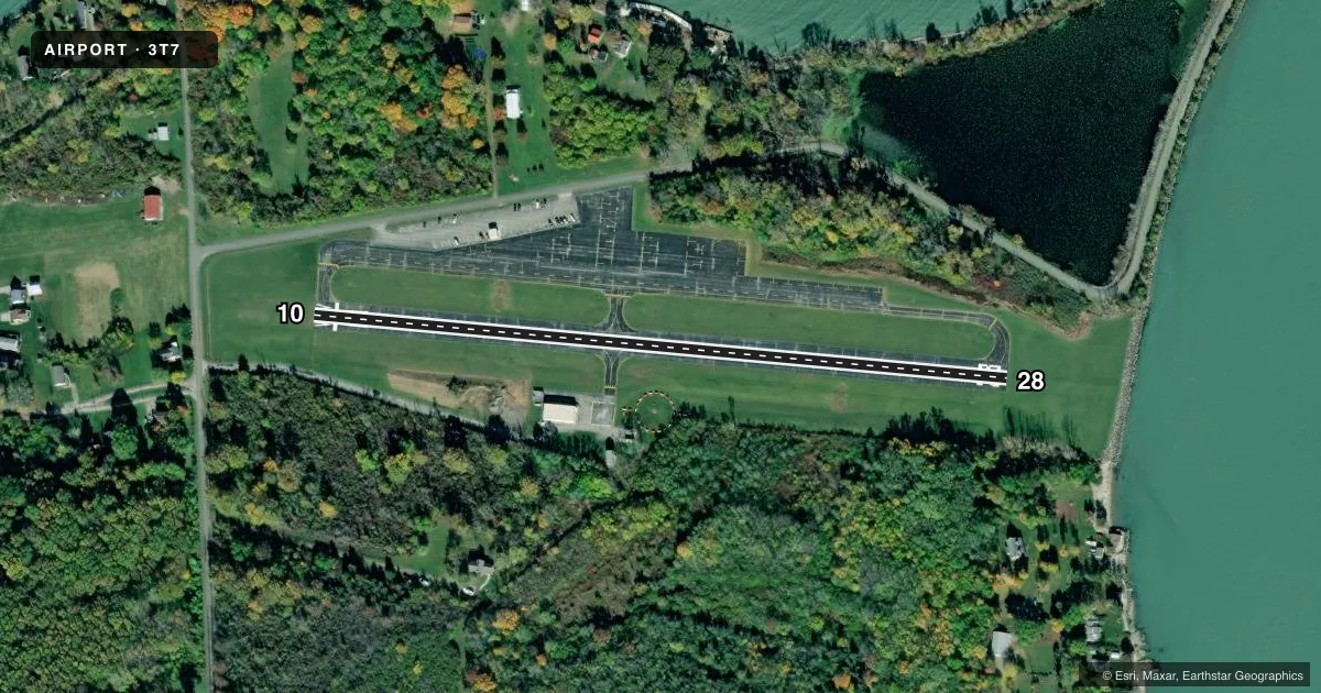
Airport sketch
Runways drawn to scale from FAA survey coordinates, rendered over satellite imagery. Not for navigation.
Approaches & charts
Services on the field
Fuel grades, oxygen, maintenance, ramp storage and lighting — as declared to the FAA by the airport operator.
Fuel & services
- Fuel
- Not available
- Oxygen (bottled)
- Not available
- Oxygen (bulk)
- Not available
- Airframe repair
- Not available
- Power plant repair
- Not available
Ramp & ground
- Transient storage
- Tie-down
- Landing fee
- Yes
- Wind indicator
- Lighted
- Segmented circle
- Yes
Fuel & FBOs
Cheapest 100LL and Jet A on the field and nearby. Always confirm with the FBO before taxi.
Airport notes
Surface conditions, obstructions, local procedures, lighting outages and other notes published with each FAA cycle.
General notes
- ALL TFC PATS RMN SOUTH OF ARPT.
- ACFT OPS PROHIBITED DUSK-DAWN.
- NO TGL; NO STUDENT TRG.
- FOR CD CTC CLEVELAND APCH AT 216-352-2323.
- HELIPAD ON SOUTH SIDE OF RWY IS RSTRD TO EMS HELICOPTERS ONLY.
Approach & departure obstructions
- 10APCH SLP TO DTHR 10:1 OVR +44 FT TREE, 454 FT DIST, 107 FT R.
Other notes
- PRVDD ALL TFC PATS RMN SOUTH OF ARPT; RWY THRS DSPLCD; RIGHT TFC PAT AT 3X5 ARPT RWY 19.
- PRKG/RAMP FEES FOR ALL PVT & COML ACFT.
- TIE DOWN STRAPS NOT PRVDD.
VFR map & nearby airports
VFR sectional. Tap any ICAO chip to open that airport.
Key facts · 3T7
Answer card- ICAO
- 3T7
- Name
- MIDDLE BASS ISLAND
- Location
- MIDDLE BASS ISLAND, OHIO
- Elevation
- 579 ft MSL
- Traffic pattern altitude
- 1,579 ft MSL (1,000 AGL)
- Control tower
- Non-towered (use CTAF)
- Total runways
- 1
- Longest runway
- 10/28 · 1,852 ft
- Published ILS approaches
- 0
- Published frequencies
- 2
- Magnetic variation
- 7°
- Current flight rules
- VFR
- Current wind
- 260° at 12 kt
- Favored runway now
- RWY 28
Middle Bass Island Airport sits on Middle Bass Island in Ohio. Field elevation is 579 ft MSL. It has one runway, 10/28, which is 1,852 ft long. There is no control tower. No ILS approaches are published. Pattern altitude is not published, so use the standard 1,000 ft AGL for light piston operations unless the current Chart Supplement says otherwise.
This is a small field with some important operating limits. Aircraft operations are prohibited from dusk to dawn. No touch-and-go operations are permitted. Student training is also not permitted. All traffic patterns remain south of the airport. Published remarks also note displaced thresholds. There is a tree on the approach path to the displaced threshold that sits 454 ft from the runway and 107 ft right of centerline. Plan your approach carefully and verify current details before departure.
There are no on-field FBOs listed, so call the airport operator or the field directly before you go. CTAF and UNICOM are both 122.8. Clearance delivery is handled through Cleveland Approach at 216-352-2323. Parking and ramp fees apply for private and commercial aircraft. Tie-down straps are not provided. The helipad on the south side of the runway is restricted to EMS helicopters only.