METAR & TAF 3X5
3X5 does not publish a METAR.
Showing the nearest reporting station: KPCW (ERIE-OTTAWA INTL) · 12.3 NM away. Conditions at 3X5 may differ.
METAR · KPCW
Observed 20:55Z
KPCW 272055Z AUTO 26012KT 10SM CLR 27/22 A2980 RMK AO2
- Wind
- 260° @ 12 kt
- Visibility
- 10 SM
- Temp / Dew
- 27°C / 22°C
- Altimeter
- 29.80 inHg
- Clouds
- CLR
- Density alt
- 2,325 ft
- Ceiling
- Unlimited
- Rules
- VFR
Airport info & contacts
Manager on record, flight service, ARTCC, attendance schedule and pattern altitude — published by the FAA and refreshed every 28 days.
Location
- From city
- 0 NM NW
- VFR sectional
- DETROIT
- ARTCC
- ZOB · CLEVELAND
- NOTAM facility
- CLE (NOTAM-D)
Airport manager
- Name
- ROSANN KEISER
- Phone
- 419-285-3371
- Address
- PEEPLES RD, ISLE SAINT GEORGE OH 43436
Flight service · Hours
- FSS CLE
- CLEVELAND1-800-WX-BRIEF
- Attendance
- Unattended
Frequencies
Tap any row to copy the frequency to your clipboard.
Runways & pattern
Full pagePattern entry · RWY 19
RIGHT TRAFFICRunway end performance
| End | TORA | TODA | ASDA | LDA | VGSI | Approach lights | Obstruction |
|---|---|---|---|---|---|---|---|
| 01 | — | — | — | — | — | — | 79', trees, 1455' from thr, 204' R of cntrln, slope 15 |
Declared distances in feet. TORA = takeoff run available, TODA = takeoff distance, ASDA = accelerate-stop, LDA = landing distance.
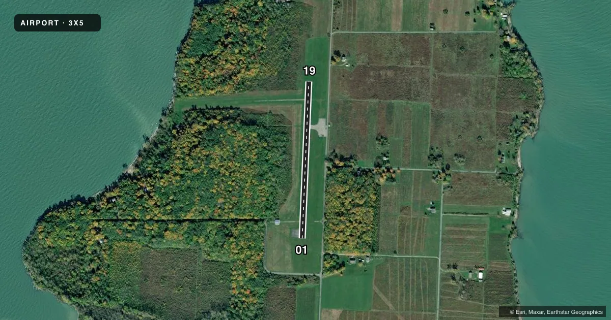
Airport sketch
Runways drawn to scale from FAA survey coordinates, rendered over satellite imagery. Not for navigation.
Approaches & charts
Services on the field
Fuel grades, oxygen, maintenance, ramp storage and lighting — as declared to the FAA by the airport operator.
Fuel & services
- Fuel
- Not available
- Oxygen (bottled)
- Not available
- Oxygen (bulk)
- Not available
- Airframe repair
- Not available
- Power plant repair
- Not available
Ramp & ground
- Transient storage
- Tie-down
- Landing fee
- No fee published
- Wind indicator
- Yes
- Segmented circle
- No
Fuel & FBOs
Cheapest 100LL and Jet A on the field and nearby. Always confirm with the FBO before taxi.
Airport notes
Surface conditions, obstructions, local procedures, lighting outages and other notes published with each FAA cycle.
General notes
- NO OPNS DUSK-DAWN.
- NO TGLS & NO STUDENT TRNG.
- FOR CD CTC DETROIT APCH AT 734-955-1404.
- ARPT LCTD NW CORNER OF ISLAND.
Other notes
- THIS AIRPORT HAS BEEN SURVEYED BY THE NATIONAL GEODETIC SURVEY.
VFR map & nearby airports
VFR sectional. Tap any ICAO chip to open that airport.
Key facts · 3X5
Answer card- ICAO
- 3X5
- Name
- NORTH BASS ISLAND
- Location
- NORTH BASS ISLAND, OHIO
- Elevation
- 594 ft MSL
- Traffic pattern altitude
- 1,594 ft MSL (1,000 AGL)
- Control tower
- Non-towered (use CTAF)
- Total runways
- 1
- Longest runway
- 01/19 · 1,804 ft
- Published ILS approaches
- 0
- Published frequencies
- 2
- Magnetic variation
- 6°
- Current flight rules
- VFR
- Current wind
- 260° at 12 kt
- Favored runway now
- RWY 19
North Bass Island Airport (3X5) sits on North Bass Island in Ohio. The field elevation is 594 ft MSL. It has one runway, 01/19, which is 1,804 ft long with an asphalt surface. The airport is not towered. CTAF and UNICOM are both 122.8.
No ILS approaches are published here. Pattern altitude is not published, so verify the current Chart Supplement before you fly. Published remarks say no operations are permitted from dusk to dawn. No touch-and-go landings are allowed. Student training is also not permitted. Clearance delivery is handled through Detroit Approach at 734-955-1404.
There are no on-field FBOs listed. Plan to self-brief carefully before arrival. The airport sits at the northwest corner of the island, so island terrain and water surroundings deserve attention during arrival and departure planning. For a first visit, the main items are the short single runway, the published night restriction and the no-training limitation. Check the current Chart Supplement for any updates before you go.