METAR & TAF KPCW
Current METAR
Observed 20:55Z
KPCW 272055Z AUTO 26012KT 10SM CLR 27/22 A2980 RMK AO2
- Wind
- 260° @ 12 kt
- Visibility
- 10 SM
- Temp / Dew
- 27°C / 22°C
- Altimeter
- 29.80 inHg
- Clouds
- CLR
- Density alt
- 2,321 ft
- Ceiling
- Unlimited
- Rules
- VFR
Airport info & contacts
Manager on record, flight service, ARTCC, attendance schedule and pattern altitude — published by the FAA and refreshed every 28 days.
Location
- From city
- 3 NM E
- VFR sectional
- DETROIT
- ARTCC
- ZOB · CLEVELAND
- NOTAM facility
- PCW (NOTAM-D)
Airport manager
- Name
- CLAYTON F FINKEN
- Phone
- 419-734-6297
- Address
- 3255 E STATE RD, PORT CLINTON OH 43452-2542
Flight service · Hours
- FSS CLE
- CLEVELAND1-800-WX-BRIEF
- Attendance
- 0700-1800
Frequencies
Tap any row to copy the frequency to your clipboard.
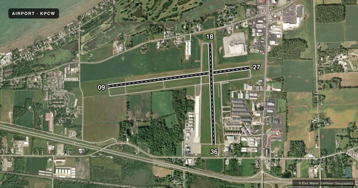
Runways & pattern
Full pagePattern entry · RWY 27
LEFT TRAFFIC| Runway | Heading (°M) | Length | Surface | Traffic |
|---|---|---|---|---|
| 09/27Favored | 76° / 256° | 5,646 ft | ASPH | Standard L |
| 18/36 | 171° / 351° | 4,002 ft | ASPH | Standard L |
Runway end performance
| End | TORA | TODA | ASDA | LDA | VGSI | Approach lights | Obstruction |
|---|---|---|---|---|---|---|---|
| 09 | — | — | — | — | PAPI 4-box left(3°) | — | 65', tree, 1825' from thr, 350' R of cntrln, slope 25 |
| 27 | — | — | — | — | PAPI 4-box left(3°) | — | 40', trees, 925' from thr, 330' R of cntrln, slope 18 |
| 36 | — | — | — | — | — | — | 85', trees, 1900' from thr, 20' R of cntrln, slope 20 |
Declared distances in feet. TORA = takeoff run available, TODA = takeoff distance, ASDA = accelerate-stop, LDA = landing distance.
Airport sketch
Runways drawn to scale from FAA survey coordinates, rendered over satellite imagery. Not for navigation.
Approaches & charts
Services on the field
Fuel grades, oxygen, maintenance, ramp storage and lighting — as declared to the FAA by the airport operator.
Fuel & services
- Fuel
- 100LLA+
- Oxygen (bottled)
- HIGH/LOW
- Oxygen (bulk)
- HIGH/LOW
- Airframe repair
- Major
- Power plant repair
- Major
- Other services
- CHTR,INSTR,PAJA,RNTL,SALES
Ramp & ground
- Transient storage
- Tie-down
- Hangar
- Landing fee
- No fee published
- Customs
- Not available
- Lighting schedule
- SEE RMK
- Beacon schedule
- SS-SR
- Beacon
- White / Green (civil land)(WG)
- Wind indicator
- Lighted
- Segmented circle
- No
Fuel & FBOs
Cheapest 100LL and Jet A on the field and nearby. Always confirm with the FBO before taxi.
Airport notes
Surface conditions, obstructions, local procedures, lighting outages and other notes published with each FAA cycle.
General notes
- TXL A CLSD TO ACFT WITH WINGSPAN GTR THAN 49 FT.
- OCCNL DEER, BIRDS & OTR WILDLIFE ON & INVOF APRT.
- FOR CD CTC CLEVELAND APCH AT 216-352-2323.
- CUST AVBL 24 HRS 7 DAYS PER WEEK. REQ MUST BE MADE TWO HRS PRIOR TO ARR. LCL OFC 419-732-4446.
Lighting notes
- ACTVT REIL RWY 09 & 27; HIRL RWY 09/27; MIRL RWY 18/36 - CTAF. PAPI RWY 09 & 27 OPR CONSLY.
Runway surface & condition
- 09/27RWY 27 CALM WIND RWY.
Other notes
- TNST HGR: PPR.
- OWNERADNL CTC: INFO@PORTCLINTONAIRPORT.COM.
VFR map & nearby airports
VFR sectional. Tap any ICAO chip to open that airport.
Key facts · KPCW
Answer card- ICAO
- KPCW
- Name
- ERIE-OTTAWA INTL
- Location
- PORT CLINTON, OHIO
- Elevation
- 590.1 ft MSL
- Traffic pattern altitude
- 1,590.1 ft MSL (1,000 AGL)
- Control tower
- Non-towered (use CTAF)
- Total runways
- 2
- Longest runway
- 09/27 · 5,646 ft
- Published ILS approaches
- 0
- Published frequencies
- 4
- Magnetic variation
- 7°
- Current flight rules
- VFR
- Current wind
- 260° at 12 kt
- Favored runway now
- RWY 27
Erie-Ottawa Intl is in Port Clinton, Ohio. The field elevation is 590.1 ft MSL. It has two asphalt runways. The longest is 5,646 ft on runway 09/27. There is no control tower, so traffic works on CTAF 122.8. Cleveland Approach handles the published approach and departure frequencies. No ILS approaches are published here.
Pattern altitude is not published. Use 1,000 ft AGL for light piston operations unless the current Chart Supplement says otherwise. The airport sits near Lake Erie traffic flow, so expect local VFR activity, wildlife on and near the field. Stay sharp on taxi and runway selection. Runway 27 is the calm wind runway per the published remarks. Lighting is available on both runways. Runways 09 and 27 have REILs and high intensity lighting. Runways 18 and 36 have medium intensity lighting. PAPI is published for 09 and 27.
Erie Ottawa International Airport Authority is the on-field FBO. It carries 100LL and Jet A Prist. Clearance delivery is handled through Cleveland Approach. Taxiway A is closed to aircraft with wingspans over 49 ft. Customs is available 24/7 with two hours prior notice. Transient hangar use needs prior permission.