METAR & TAF 5A1
5A1 does not publish a METAR.
Showing the nearest reporting station: KLPR (LORAIN COUNTY RGNL) · 17.9 NM away. Conditions at 5A1 may differ.
METAR · KLPR
Observed 14:53Z
KLPR 271453Z AUTO 28007KT 10SM SCT021 BKN026 BKN033 26/22 A2991 RMK AO2 SLP121 T02610217 51001
- Wind
- 280° @ 7 kt
- Visibility
- 10 SM
- Temp / Dew
- 26°C / 22°C
- Altimeter
- 29.91 inHg
- Clouds
- BKN
- Density alt
- 2,390 ft
- Ceiling
- 2,600 ft AGL
- Rules
- MVFR
Airport info & contacts
Manager on record, flight service, ARTCC, attendance schedule and pattern altitude — published by the FAA and refreshed every 28 days.
Location
- From city
- 3 NM E
- VFR sectional
- DETROIT
- ARTCC
- ZOB · CLEVELAND
- NOTAM facility
- CLE (NOTAM-D)
Airport manager
- Name
- SCOTT SPARKS
- Phone
- 419-668-5400
- Address
- 961 US HIGHWAY 20 E, PO BOX 406, NORWALK OH 44857-0406
Flight service · Hours
- FSS CLE
- CLEVELAND1-800-WX-BRIEF
- Attendance
- Unattended
Frequencies
Tap any row to copy the frequency to your clipboard.
Runways & pattern
Full pagePattern entry · RWY 28
LEFT TRAFFICRunway end performance
| End | TORA | TODA | ASDA | LDA | VGSI | Approach lights | Obstruction |
|---|---|---|---|---|---|---|---|
| 10 | — | — | — | — | — | — | 31', trees, 346' from thr, 126' R of cntrln, slope 4 |
| 28 | — | — | — | — | — | — | 17', road, 201' from thr, 240' R of cntrln, slope 0 |
Declared distances in feet. TORA = takeoff run available, TODA = takeoff distance, ASDA = accelerate-stop, LDA = landing distance.
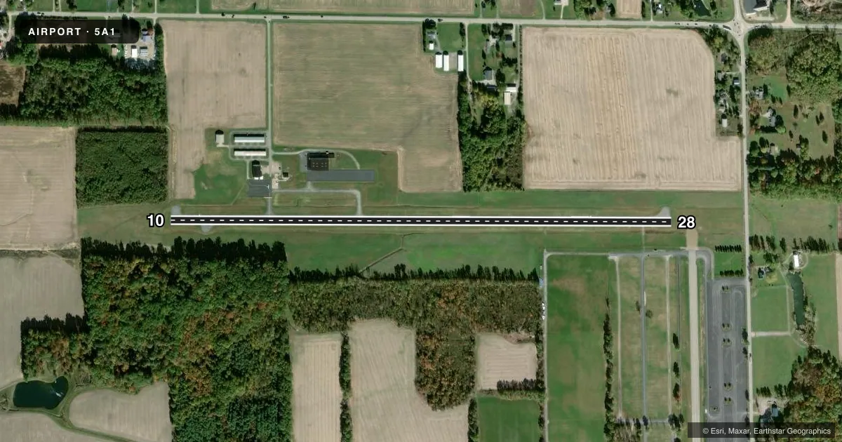
Airport sketch
Runways drawn to scale from FAA survey coordinates, rendered over satellite imagery. Not for navigation.
Approaches & charts
Services on the field
Fuel grades, oxygen, maintenance, ramp storage and lighting — as declared to the FAA by the airport operator.
Fuel & services
- Fuel
- 100LLA
- Oxygen (bottled)
- Not available
- Oxygen (bulk)
- Not available
- Airframe repair
- Not available
- Power plant repair
- Minor
- Other services
- INSTR
Ramp & ground
- Transient storage
- Tie-down
- Hangar
- Landing fee
- No fee published
- Customs
- Not available
- Lighting schedule
- SEE RMK
- Beacon schedule
- SS-SR
- Beacon
- White / Green (civil land)(WG)
- Wind indicator
- Lighted
- Segmented circle
- No
Fuel & FBOs
Cheapest 100LL and Jet A on the field and nearby. Always confirm with the FBO before taxi.
Airport notes
Surface conditions, obstructions, local procedures, lighting outages and other notes published with each FAA cycle.
General notes
- DRAG STRIP AT EAST END OF RWY, SOUTH SIDE, RUNNING NORTH/SOUTH.
- BIRDS & WILDLIFE ON & INVOF ARPT.
- RWY 28: 67 FT LGT POLES, 95 FT DIST, 320 FT LEFT IN TRSNL SFC, OBSTN MKD & LGTD.
- FOR CD CTC CLEVELAND APCH AT 216-352-2323, WHEN APCH CLSD CTC CLEVELAND ARTCC AT 440-774-0222/0490.
Lighting notes
- ACTVT MIRL RWY 10/28 - CTAF.
Approach & departure obstructions
- 2817 FT DRAG STRIP, 152 FT DIST, 242 FT L.
- 10APCH SLP 18:1 TO DTHR OVR 31 FT TREES, 585 FT DIST, 126 FT R.
- 28OBSTN CLNC SLP 0:1 TO DTHR OVR 8 FT FENCE, 0 FT DIST, 245 FT L; 12:1 OVR 110 FT TREES, 1390 FT DIST, 225 FT R.
Other notes
- VFR USE ONLY.
- PRIOR CDN RQRD.
VFR map & nearby airports
VFR sectional. Tap any ICAO chip to open that airport.
Key facts · 5A1
Answer card- ICAO
- 5A1
- Name
- NORWALK/HURON COUNTY
- Location
- NORWALK, OHIO
- Elevation
- 852.5 ft MSL
- Traffic pattern altitude
- 1,852.5 ft MSL (1,000 AGL)
- Control tower
- Non-towered (use CTAF)
- Total runways
- 1
- Longest runway
- 10/28 · 4,208 ft
- Published ILS approaches
- 0
- Published frequencies
- 4
- Magnetic variation
- 6°
- Current flight rules
- MVFR
- Current wind
- 280° at 7 kt
- Favored runway now
- RWY 28
Norwalk/Huron County Airport sits in Norwalk, Ohio at 852.5 ft MSL. It has one runway, 10/28, which is 4,208 ft long. The field is non-towered. Pattern altitude is not published, so use the standard 1,000 ft AGL for light piston operations unless the current Chart Supplement says otherwise. No ILS approaches are published here.
The on-field FBO is Norwalk-Huron County Airport. It carries 100LL and Jet A. Call (419) 668-5400 before you go if you need current service details.
This is a VFR-only field. Prior coordination is required. Cleveland Approach handles clearance delivery. ARTCC backup is used when Approach is closed. Runway 10/28 has medium intensity lighting that is activated by CTAF. Watch the published obstructions near runway 28. There is also a drag strip near the east end of the runway on the south side. Birds and wildlife are reported on and near the airport. Keep a sharp scan on departure and arrival. If you are planning a first visit, verify the current Chart Supplement for any operational notes before you launch.