METAR & TAF KLPR
Current METAR
Observed 19:53Z
KLPR 271953Z AUTO 25011KT 10SM FEW039 28/21 A2982 RMK AO2 SLP092 T02830211
- Wind
- 250° @ 11 kt
- Visibility
- 10 SM
- Temp / Dew
- 28°C / 21°C
- Altimeter
- 29.82 inHg
- Clouds
- FEW
- Density alt
- 2,668 ft
- Ceiling
- Unlimited
- Rules
- VFR
Airport info & contacts
Manager on record, flight service, ARTCC, attendance schedule and pattern altitude — published by the FAA and refreshed every 28 days.
Location
- From city
- 6 NM S
- VFR sectional
- DETROIT
- ARTCC
- ZOB · CLEVELAND
- NOTAM facility
- LPR (NOTAM-D)
Airport manager
- Name
- DOUG MCCONNELL C/O MRK AVIATION
- Phone
- 440-323-7000
- Address
- 44050 RUSSIA RD, ELYRIA OH 44035
Flight service · Hours
- FSS CLE
- CLEVELAND1-800-WX-BRIEF
- Attendance
- APR-OCT · 0700-2200
- NOV-MAR · 0700-2100
Frequencies
Tap any row to copy the frequency to your clipboard.
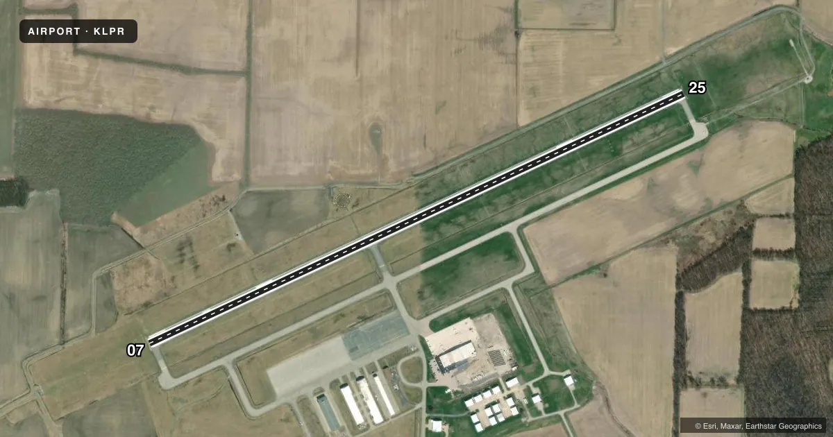
Runways & pattern
Full pagePattern entry · RWY 25
RIGHT TRAFFICRunway end performance
| End | TORA | TODA | ASDA | LDA | VGSI | Approach lights | Obstruction |
|---|---|---|---|---|---|---|---|
| 07 | — | — | — | — | PAPI 4-box left(3°) | MALSR | 45', tree, 1932' from thr, 730' R of cntrln, slope 38 |
| 25 | — | — | — | — | PAPI 4-box left(3°) | — | — |
Declared distances in feet. TORA = takeoff run available, TODA = takeoff distance, ASDA = accelerate-stop, LDA = landing distance.
Airport sketch
Runways drawn to scale from FAA survey coordinates, rendered over satellite imagery. Not for navigation.
Approaches & charts
ILS · 1
Services on the field
Fuel grades, oxygen, maintenance, ramp storage and lighting — as declared to the FAA by the airport operator.
Fuel & services
- Fuel
- 100LLA
- Oxygen (bottled)
- Not available
- Oxygen (bulk)
- HIGH/LOW
- Airframe repair
- Major
- Power plant repair
- Major
- Other services
- AMB,AVNCS,CARGO,CHTR,INSTR,RNTL,SALES
Ramp & ground
- Transient storage
- Tie-down
- Hangar
- Landing fee
- Yes
- Customs
- Not available
- Lighting schedule
- SEE RMK
- Beacon schedule
- SS-SR
- Beacon
- White / Green (civil land)(WG)
- Wind indicator
- Lighted
Fuel & FBOs
Cheapest 100LL and Jet A on the field and nearby. Always confirm with the FBO before taxi.
Airport notes
Surface conditions, obstructions, local procedures, lighting outages and other notes published with each FAA cycle.
General notes
- PILOTS OPERG IN OBERLIN AREA REQD TO AVOID & RMN WELL CLR OF OBERLIN COLLEGE DUE TO MUSIC CONSERVATORY; ALL TFC OPNS NORTH OF ARPT AS PER FAR PART 93 SUBPART J.
- DEER, BIRDS & OTHER WILDLIFE ON & INVOF ARPT.
- FOR CD CTC CLEVELAND APCH AT 216-352-2323.
Lighting notes
- HIRL RWY 07/25 PRESET LOW INTST, TO INCR INTST & ACTVT MALSR RWY 07; REIL RWY 25 - CTAF.
Other notes
- THIS AIRPORT HAS BEEN SURVEYED BY THE NATIONAL GEODETIC SURVEY.
- TNST HNGR STORAGE PPR.
- MANAGERAPT MGR CELL PHONE 216-389-6042 OR 330-721-8142
VFR map & nearby airports
VFR sectional. Tap any ICAO chip to open that airport.
Key facts · KLPR
Answer card- ICAO
- KLPR
- Name
- LORAIN COUNTY RGNL
- Location
- LORAIN/ELYRIA, OHIO
- Elevation
- 793.2 ft MSL
- Traffic pattern altitude
- 1,793.2 ft MSL (1,000 AGL)
- Control tower
- Non-towered (use CTAF)
- Total runways
- 1
- Longest runway
- 07/25 · 5,002 ft
- Published ILS approaches
- 1
- Published frequencies
- 5
- Magnetic variation
- 8°
- Current flight rules
- VFR
- Current wind
- 250° at 11 kt
- Favored runway now
- RWY 25
Lorain County Rgnl is in Lorain/Elyria, Ohio. Field elevation is 793.2 ft MSL. The airport has one runway. Runway 07/25 is 5,002 ft of asphalt. There is no control tower. Cleveland Approach handles clearance delivery and approach services. The published ILS is for runway 07.
Pattern altitude is not published. Use the standard 1,000 ft AGL pattern unless ATC or the current Chart Supplement says otherwise. That puts the light piston pattern at about 1,793 ft MSL. MRK Aviation is on the field. It carries 100LL, Jet A and Jet A Prist. The airport remarks also note low-intensity preset runway lights on 07/25. Use CTAF to increase intensity. Use CTAF to activate the MALSR for runway 07. Runway 25 end identifier lights are also CTAF-controlled.
First-time pilots should pay close attention to the published Oberlin-area traffic note. Keep clear of Oberlin College and follow the FAR Part 93 Subpart J traffic flow north of the airport. Wildlife is also a real factor here. Deer and birds are reported on and near the field. Transient hangar storage needs prior permission. For current operational details, check the current FAA Chart Supplement or call the airport operator or MRK Aviation before you go.