METAR & TAF 1G1
1G1 does not publish a METAR.
Showing the nearest reporting station: KLPR (LORAIN COUNTY RGNL) · 3.6 NM away. Conditions at 1G1 may differ.
METAR · KLPR
Observed 19:53Z
KLPR 271953Z AUTO 25011KT 10SM FEW039 28/21 A2982 RMK AO2 SLP092 T02830211
- Wind
- 250° @ 11 kt
- Visibility
- 10 SM
- Temp / Dew
- 28°C / 21°C
- Altimeter
- 29.82 inHg
- Clouds
- FEW
- Density alt
- 2,624 ft
- Ceiling
- Unlimited
- Rules
- VFR
Airport info & contacts
Manager on record, flight service, ARTCC, attendance schedule and pattern altitude — published by the FAA and refreshed every 28 days.
Location
- From city
- 2 NM S
- VFR sectional
- DETROIT
- ARTCC
- ZOB · CLEVELAND
- NOTAM facility
- CLE (NOTAM-D)
Airport manager
- Name
- ANGELO GOUSIOS
- Phone
- 440-343-4943
- Address
- 3593 MEDINA RD #319, MEDINA OH 44256-8182
Flight service · Hours
- FSS CLE
- CLEVELAND1-800-WX-BRIEF
- Attendance
- MON-FRI · 0800-1700
Frequencies
Tap any row to copy the frequency to your clipboard.
Runways & pattern
Full pagePattern entry · RWY 27
LEFT TRAFFICRunway end performance
| End | TORA | TODA | ASDA | LDA | VGSI | Approach lights | Obstruction |
|---|---|---|---|---|---|---|---|
| 09 | — | — | — | — | — | — | 85', tree, 201' from thr, 105' R of cntrln, slope 0 |
| 27 | — | — | — | — | — | — | 85', tree, 201' from thr, 125' R of cntrln, slope 0 |
Declared distances in feet. TORA = takeoff run available, TODA = takeoff distance, ASDA = accelerate-stop, LDA = landing distance.
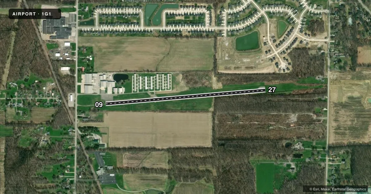
Airport sketch
Runways drawn to scale from FAA survey coordinates, rendered over satellite imagery. Not for navigation.
Approaches & charts
Services on the field
Fuel grades, oxygen, maintenance, ramp storage and lighting — as declared to the FAA by the airport operator.
Fuel & services
- Fuel
- 100LL
- Airframe repair
- Major
- Power plant repair
- Major
- Other services
- AVNCS
Ramp & ground
- Transient storage
- Not published
- Landing fee
- No fee published
- Customs
- Not available
- Lighting schedule
- SS-SR
- Beacon schedule
- SS-SR
- Beacon
- White / Green (civil land)(WG)
- Wind indicator
- Yes
- Segmented circle
- No
Fuel & FBOs
Cheapest 100LL and Jet A on the field and nearby. Always confirm with the FBO before taxi.
Airport notes
Surface conditions, obstructions, local procedures, lighting outages and other notes published with each FAA cycle.
General notes
- DEER & BIRDS ON & INVOF ARPT.
- FOR CD CTC CLEVELAND APCH AT 216-352-2323.
Fuel notes
- 100LLFUEL AVBL H24 VIA CREDIT CARD.
Runway surface & condition
- 09/27NSTD LIRL DUE TO 18 INCH NON-FRANGIBLE MOUNTING STAKES.
Approach & departure obstructions
- 0910 FT BRUSH & 70 FT TREES, 100-199 FT DIST, 102 FT R.
Other notes
- THIS AIRPORT HAS BEEN SURVEYED BY THE NATIONAL GEODETIC SURVEY.
- VFR ONLY.
- 1UNATNDD MAJOR HOLS.
- MANAGERARPT PHYS ADS: 10875 MIDDLE AVE, ELYRIA, OH 44035-7802.
- MANAGEROR 440-458-4215.
VFR map & nearby airports
VFR sectional. Tap any ICAO chip to open that airport.
Key facts · 1G1
Answer card- ICAO
- 1G1
- Name
- ELYRIA
- Location
- ELYRIA, OHIO
- Elevation
- 757.8 ft MSL
- Traffic pattern altitude
- 1,757.8 ft MSL (1,000 AGL)
- Control tower
- Non-towered (use CTAF)
- Total runways
- 1
- Longest runway
- 09/27 · 3,053 ft
- Published ILS approaches
- 0
- Published frequencies
- 5
- Magnetic variation
- 6°
- Current flight rules
- VFR
- Current wind
- 250° at 11 kt
- Favored runway now
- RWY 27
Elyria Airport is in Elyria, Ohio. The field elevation is 757.8 ft MSL. It has one runway. Runway 09/27 is 3,053 ft long with asphalt pavement. The airport is not towered. Cleveland Approach handles clearance delivery and approach or departure services. No ILS approaches are published here.
Pattern altitude is not published. Use the standard 1,000 ft AGL pattern unless the current FAA Chart Supplement or local traffic calls for something different. The airport is VFR only. That matters if you are planning an IFR arrival or departure. Check the current Chart Supplement before you go.
Elyria Airport has one on-field FBO. Elyria Airport carries 100LL. Fuel is available 24 hours a day by credit card. Published remarks also note nonstandard low-intensity runway lights on 09/27 because of the mounting stakes. There is brush and trees near the departure end area for runway 09. Deer and birds are also reported on and near the airport. If you are new to the field, plan for a straightforward non-towered arrival with local traffic awareness and verify current procedures with the airport operator or the FBO directly by phone.