METAR & TAF 15G
15G does not publish a METAR.
Showing the nearest reporting station: KBJJ (WAYNE COUNTY) · 10.1 NM away. Conditions at 15G may differ.
METAR · KBJJ
Observed 11:20Z
KBJJ 271120Z AUTO 11007KT 3SM BR BKN006 OVC015 18/17 A3003 RMK AO2 RAE08 P0000 T01780172
- Wind
- 110° @ 7 kt
- Visibility
- 3 SM
- Temp / Dew
- 18°C / 17°C
- Altimeter
- 30.03 inHg
- Clouds
- OVC
- Density alt
- 1,724 ft
- Ceiling
- 600 ft AGL
- Rules
- IFR
Airport info & contacts
Manager on record, flight service, ARTCC, attendance schedule and pattern altitude — published by the FAA and refreshed every 28 days.
Location
- From city
- 3 NM W
- VFR sectional
- DETROIT
- Pattern altitude
- 790 ft AGL · 2,000 ft MSL
- ARTCC
- ZOB · CLEVELAND
- NOTAM facility
- CLE (NOTAM-D)
Airport manager
- Name
- JOEL KULL
- Phone
- 330-573-6437
- Address
- 3071 GREENWICH RD, WADSWORTH OH 44281-9516
Flight service · Hours
- FSS CLE
- CLEVELAND1-800-WX-BRIEF
- Attendance
- DAWN TO DUSK
Frequencies
Tap any row to copy the frequency to your clipboard.
Runways & pattern
Full pagePattern entry · RWY 03
LEFT TRAFFICRunway end performance
| End | TORA | TODA | ASDA | LDA | VGSI | Approach lights | Obstruction |
|---|---|---|---|---|---|---|---|
| 03 | — | — | — | — | PSIL | — | 8', crops, 201' from thr, 85' R of cntrln, slope 0 |
| 21 | — | — | — | — | PSIL | — | 55', trees, 385' from thr, 145' R of cntrln, slope 3 |
Declared distances in feet. TORA = takeoff run available, TODA = takeoff distance, ASDA = accelerate-stop, LDA = landing distance.
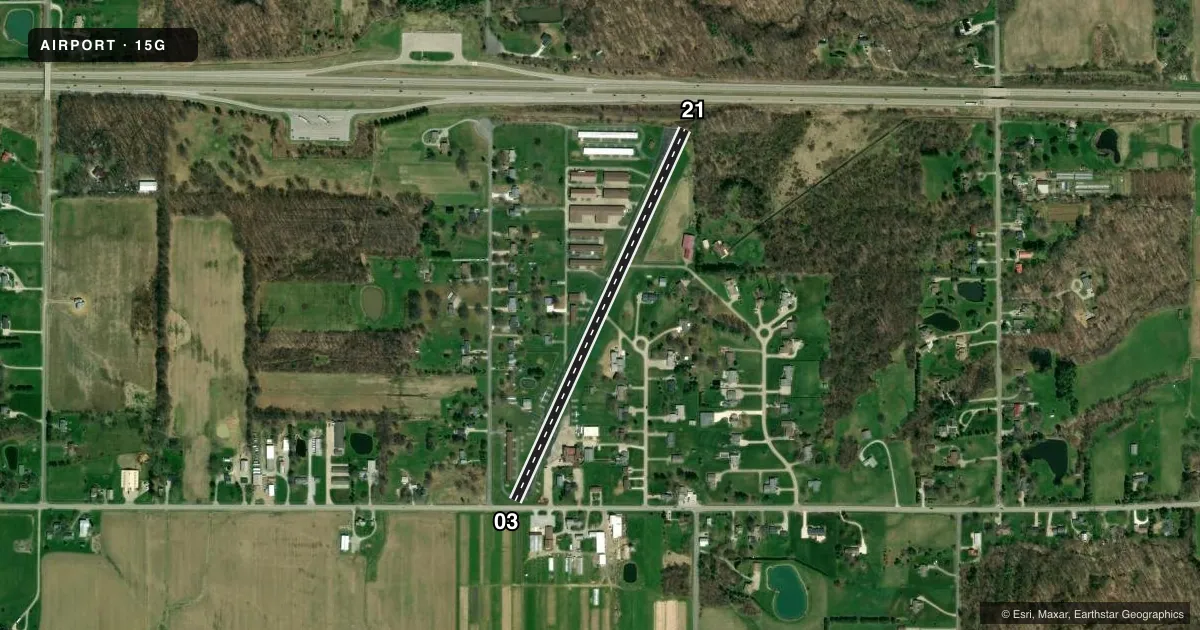
Airport sketch
Runways drawn to scale from FAA survey coordinates, rendered over satellite imagery. Not for navigation.
Approaches & charts
Services on the field
Fuel grades, oxygen, maintenance, ramp storage and lighting — as declared to the FAA by the airport operator.
Fuel & services
- Fuel
- 100LL
- Oxygen (bottled)
- Not available
- Oxygen (bulk)
- Not available
- Airframe repair
- Major
- Power plant repair
- Major
- Other services
- CHTR,INSTR,RNTL
Ramp & ground
- Transient storage
- Tie-down
- Hangar
- Landing fee
- No fee published
- Customs
- Not available
- Lighting schedule
- SEE RMK
- Beacon schedule
- SS-SR
- Beacon
- White / Green (civil land)(WG)
- Wind indicator
- Lighted
- Segmented circle
- No
Fuel & FBOs
Cheapest 100LL and Jet A on the field and nearby. Always confirm with the FBO before taxi.
Airport notes
Surface conditions, obstructions, local procedures, lighting outages and other notes published with each FAA cycle.
General notes
- TGL PROHIBITED.
- OCNL BIRDS & WILDLIFE ON & INVOF ARPT.
- FOR CD CTC CLEVELAND APCH AT 216-352-2323.
Lighting notes
- ACTVT NSTD LIRL RWY 03/21 - CTAF.
Runway surface & condition
- 03/21LTD TO 6500 LBS PER AMGR.
- 03/21NSTD LIRL DUE TO INCOR COLORS & MOUNTING ON 6 IN PVC PIPE.
Approach & departure obstructions
- 0315 FT ROAD, 0 FT DIST, 55 FT R; +8 FT SIGN, 85 FT L; 25 FT PLINE, 105 FT L/R.
- 2110-15 FT BRUSH & TREES, 0 FT DIST FM RWY END; 25-30 FT TREES, L/R; 1 FT GUARD RAIL, ACRS RWY END.
- 03APCH RATIO 0:1 TO DTHR OVR 25 FT HNGR, 0 FT DIST, 100 FT L.
- 21OBSTN CLNC SLP 0:1 TO DTHR OVR 25 FT TREES, 0 FT DIST, 45 FT L.
Other notes
- VFR ONLY.
- PRIOR CDN RQRD FOR TSNT HNGR.
- PRIOR CDN RQRD FOR TSNT TIEDOWN.
- OWNERWELTZIENSKYPARK@GMAIL.COM.
VFR map & nearby airports
VFR sectional. Tap any ICAO chip to open that airport.
Key facts · 15G
Answer card- ICAO
- 15G
- Name
- WELTZIEN SKYPARK
- Location
- WADSWORTH, OHIO
- Elevation
- 1,210 ft MSL
- Traffic pattern altitude
- 2,000 ft MSL (790 AGL)
- Control tower
- Non-towered (use CTAF)
- Total runways
- 1
- Longest runway
- 03/21 · 2,410 ft
- Published ILS approaches
- 0
- Published frequencies
- 2
- Magnetic variation
- 6°
- Current flight rules
- IFR
- Current wind
- 110° at 7 kt
- Favored runway now
- RWY 03
Weltzien Skypark is in Wadsworth, Ohio. The field elevation is 1,210 ft MSL. It has one runway, 03/21, which is 2,410 ft long and paved. There is no control tower. CTAF and UNICOM are both 123.05. No ILS approaches are published.
The pattern altitude is 790 ft AGL, which is 2,000 ft MSL. The field is VFR only, so plan accordingly before you go. Touch-and-go landings are prohibited. Prior coordination is required for transient tiedown and transient hangar use. For clearance delivery, contact Cleveland Approach at 216-352-2323.
The on-field FBO is Weltzien Skypark. It carries 100LL. Call (330) 334-9921 before arrival if you need current field coordination or fuel confirmation. Published remarks also note nonstandard low-intensity runway lights on 03/21. The lights are activated by CTAF. There are obstruction notes near both runway ends, including brush, trees, a guard rail, a hangar and power lines. That makes a careful look at runway condition and departure path important, especially on 03 and 21. Occasional birds and wildlife are also reported on and near the airport.