METAR & TAF 4G8
4G8 does not publish a METAR.
Showing the nearest reporting station: KCLE (CLEVELAND-HOPKINS INTL) · 7.2 NM away. Conditions at 4G8 may differ.
METAR · KCLE
Observed 12:51Z
KCLE 271251Z 22005KT 10SM BKN150 BKN250 23/21 A2988 RMK AO2 SLP129 T02280206 $
- Wind
- 220° @ 5 kt
- Visibility
- 10 SM
- Temp / Dew
- 23°C / 21°C
- Altimeter
- 29.88 inHg
- Clouds
- BKN
- Density alt
- 2,015 ft
- Ceiling
- 15,000 ft AGL
- Rules
- VFR
Airport info & contacts
Manager on record, flight service, ARTCC, attendance schedule and pattern altitude — published by the FAA and refreshed every 28 days.
Location
- From city
- 1 NM WNW
- VFR sectional
- DETROIT
- ARTCC
- ZOB · CLEVELAND
- NOTAM facility
- CLE (NOTAM-D)
Airport manager
- Name
- DAVID SAVILLE
- Phone
- 757-510-6788
- Address
- PO BOX 599, COLUMBIA STATION OH 44028-0599
Flight service · Hours
- FSS CLE
- CLEVELAND1-800-WX-BRIEF
- Attendance
- MON-FRI · 0900-1700
- SAT-SUN · IREG
Frequencies
Tap any row to copy the frequency to your clipboard.
Runways & pattern
Full pagePattern entry · RWY 18
LEFT TRAFFICRunway end performance
| End | TORA | TODA | ASDA | LDA | VGSI | Approach lights | Obstruction |
|---|---|---|---|---|---|---|---|
| 18 | — | — | — | — | — | — | 70', trees, 205' from thr, 70' R of cntrln, slope 0 |
| 36 | — | — | — | — | — | — | 15', tree, 201' from thr, 125' R of cntrln, slope 0 |
Declared distances in feet. TORA = takeoff run available, TODA = takeoff distance, ASDA = accelerate-stop, LDA = landing distance.
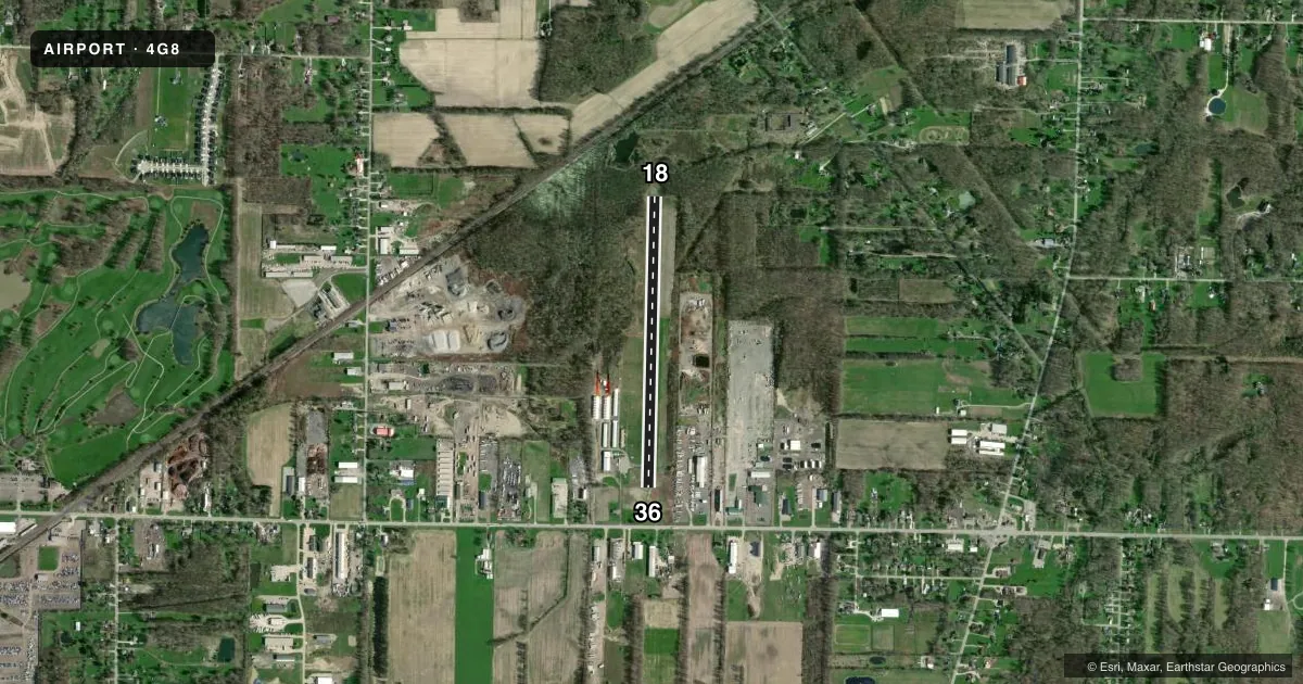
Airport sketch
Runways drawn to scale from FAA survey coordinates, rendered over satellite imagery. Not for navigation.
Approaches & charts
Services on the field
Fuel grades, oxygen, maintenance, ramp storage and lighting — as declared to the FAA by the airport operator.
Fuel & services
- Fuel
- Not available
Ramp & ground
- Transient storage
- Tie-down
- Hangar
- Landing fee
- No fee published
- Customs
- Not available
- Lighting schedule
- SEE RMK
- Wind indicator
- Yes
- Segmented circle
- No
Fuel & FBOs
Cheapest 100LL and Jet A on the field and nearby. Always confirm with the FBO before taxi.
Airport notes
Surface conditions, obstructions, local procedures, lighting outages and other notes published with each FAA cycle.
General notes
- FOR CD CTC CLEVELAND APCH AT 216-352-2323.
- OCNL DEER, BIRDS, & OTR WILDLIFE ON & INVOF ARPT.
Lighting notes
- NSTD LIRL RWY 18/36 OTS INDEFLY.
Runway surface & condition
- 18/36CLSD DLY SS-SR.
- 18/36NSTD LIRL DUE TO MISG THR LGTS.
Approach & departure obstructions
- 1840 FT TREES, 0-200 FT DIST, 50 FT L, 95 FT R; 45 FT TREES, 0 FT DIST TO DTHR, 95 FT R.
- 18NSTD NRS ONLY DUE TO NO DTHR MKGS, NO ARROWHEADS; NORTH 300 FT UNMKD.
- 36NSTD NRS ONLY DUE TO NO DTHR MKGS, NO ARROWHEADS; NORTH 300 FT UNMKD.
- 18OBSTN CLNC SLP 7:1 TO DTHR.
- 36OBSTN CLNC SLP 11:1 TO DTHR OVR 50 FT TREE, 375 FT DIST, 135 FT L.
Other notes
- THIS AIRPORT HAS BEEN SURVEYED BY THE NATIONAL GEODETIC SURVEY.
- ESTABD BFR 1959.
- PRIOR CDN RQRD.
- ROPES NOT PRVDD FOR TSNT TIEDOWN.
- 2UNATNDD MAJOR HOLS.
- MANAGER4G8COLUMBIAAIRPORT@GMAIL.COM.
VFR map & nearby airports
VFR sectional. Tap any ICAO chip to open that airport.
Key facts · 4G8
Answer card- ICAO
- 4G8
- Name
- COLUMBIA
- Location
- COLUMBIA STATION, OHIO
- Elevation
- 810.7 ft MSL
- Traffic pattern altitude
- 1,810.7 ft MSL (1,000 AGL)
- Control tower
- Non-towered (use CTAF)
- Total runways
- 1
- Longest runway
- 18/36 · 3,152 ft
- Published ILS approaches
- 0
- Published frequencies
- 2
- Magnetic variation
- 6°
- Current flight rules
- VFR
- Current wind
- 220° at 5 kt
- Favored runway now
- RWY 18
Columbia Airport (4G8) sits in Columbia Station, Ohio. Field elevation is 810.7 ft MSL. The airport has one runway. Runway 18/36 is 3,152 ft long with asphalt surface. There is no control tower. UNICOM and CTAF are both 122.8. No ILS approaches are published here.
Pattern altitude is not published. For light piston traffic, use the standard 1,000 ft AGL unless the current Chart Supplement or local procedures say otherwise. The runway is marked with nonstandard numbers only. The north 300 ft are unmarked. Runway 36 is listed as the calm wind runway. Published remarks also say prior coordination is required. The runway lights are nonstandard low-intensity lights. They are out of service indefinitely. Runway 18 has trees 35 ft high near the approach area. Runway 36 has an obstacle clearance slope to the displaced threshold. The airport manager can be reached at 4G8COLUMBIAAIRPORT@GMAIL.COM.
There are no on-field FBOs listed. Plan ahead for self-announce ops on CTAF. Check the current FAA Chart Supplement before you go. That is the best source for any current runway status, lighting, or local operating notes at this field.