METAR & TAF 1G5
1G5 does not publish a METAR.
Showing the nearest reporting station: KAKR (AKRON FULTON INTL) · 14.6 NM away. Conditions at 1G5 may differ.
METAR · KAKR
Observed 11:54Z
KAKR 271154Z AUTO 20005KT 9SM CLR 21/19 A2991 RMK AO2 SLP120 70002 T02060194 10206 20189 52008
- Wind
- 200° @ 5 kt
- Visibility
- 9 SM
- Temp / Dew
- 21°C / 19°C
- Altimeter
- 29.91 inHg
- Clouds
- CLR
- Density alt
- 2,208 ft
- Ceiling
- Unlimited
- Rules
- VFR
Airport info & contacts
Manager on record, flight service, ARTCC, attendance schedule and pattern altitude — published by the FAA and refreshed every 28 days.
Location
- From city
- 4 NM E
- VFR sectional
- DETROIT
- ARTCC
- ZOB · CLEVELAND
- NOTAM facility
- CLE (NOTAM-D)
Airport manager
- Name
- GREG HUBER
- Phone
- 330-239-1606
- Address
- PO BOX 703, MEDINA OH 44258-0703
Flight service · Hours
- FSS CLE
- CLEVELAND1-800-WX-BRIEF
- Attendance
- APR-OCT · 0800-2000
- NOV-MAR · 0800-1700
Frequencies
Tap any row to copy the frequency to your clipboard.
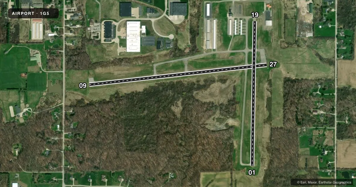
Runways & pattern
Full pagePattern entry · RWY 19
LEFT TRAFFIC| Runway | Heading (°M) | Length | Surface | Traffic |
|---|---|---|---|---|
| 09/27 | 77° / 257° | 3,556 ft | ASPH | Standard L |
| 01/19Favored | 354° / 174° | 2,868 ft | ASPH | Standard L |
Runway end performance
| End | TORA | TODA | ASDA | LDA | VGSI | Approach lights | Obstruction |
|---|---|---|---|---|---|---|---|
| 09 | — | — | — | — | PAPI 4-box left(3°) | — | 50', tree, 515' from thr, 230' R of cntrln, slope 6 |
| 27 | — | — | — | — | PAPI 4-box left(3.5°) | — | — |
| 01 | — | — | — | — | PAPI 4-box left(3°) | — | 15', pline, 450' from thr, 0' R of cntrln, slope 16 |
| 19 | — | — | — | — | PAPI 4-box left(4°) | — | 80', trees, 625' from thr, 170' R of cntrln, slope 5 |
Declared distances in feet. TORA = takeoff run available, TODA = takeoff distance, ASDA = accelerate-stop, LDA = landing distance.
Airport sketch
Runways drawn to scale from FAA survey coordinates, rendered over satellite imagery. Not for navigation.
Approaches & charts
Services on the field
Fuel grades, oxygen, maintenance, ramp storage and lighting — as declared to the FAA by the airport operator.
Fuel & services
- Fuel
- 100LLA+
- Airframe repair
- Major
- Power plant repair
- Major
- Other services
- INSTR,RNTL,SURV
Ramp & ground
- Transient storage
- Tie-down
- Hangar
- Landing fee
- No fee published
- Customs
- Not available
- Lighting schedule
- SEE RMK
- Beacon schedule
- SS-SR
- Beacon
- White / Green (civil land)(WG)
- Wind indicator
- Lighted
- Segmented circle
- Yes
Fuel & FBOs
Cheapest 100LL and Jet A on the field and nearby. Always confirm with the FBO before taxi.
Airport notes
Surface conditions, obstructions, local procedures, lighting outages and other notes published with each FAA cycle.
General notes
- DEER, BIRDS, & OTR WILDLIFE ON & INVOF ARPT.
- FOR CD CTC CLEVELAND APCH AT 216-352-2323.
- NOISE SENSITIVE RESIDENTIAL AND LIVESTOCK AREAS INVOF ALL RWY ENDS. MNTN RWY HDG TIL RCHNG TPA.
Lighting notes
- ACTVT REIL RWY 27; PAPI RWY 01, 19, & 27; MIRL RWY 01/19 & 09/27 - CTAF. PAPI RWY 01, 19, & 27 OPR CONSLY DUSK-2200.
Fuel notes
- 100LLAVBL H24 SELF SER.
Approach & departure obstructions
- 09+4-6 FT BRUSH, 100-200 FT DIST, 180-200 FT R.
- 27+0-10 FT BRUSH 175-200 FT FM 100 FT R.
- 09U/S INDEFLY.
- 01ADNL OBST: +15 FT ROAD 380 FT FM 140 FT L&R 12:1 OBST CLNS SLOPE NOT MKD OR LGTD.
Other notes
- TNST HANGAR: PPR.
VFR map & nearby airports
VFR sectional. Tap any ICAO chip to open that airport.
Key facts · 1G5
Answer card- ICAO
- 1G5
- Name
- MEDINA MUNI
- Location
- MEDINA, OHIO
- Elevation
- 1,189.8 ft MSL
- Traffic pattern altitude
- 2,189.8 ft MSL (1,000 AGL)
- Control tower
- Non-towered (use CTAF)
- Total runways
- 2
- Longest runway
- 09/27 · 3,556 ft
- Published ILS approaches
- 0
- Published frequencies
- 4
- Magnetic variation
- 7°
- Current flight rules
- VFR
- Current wind
- 200° at 5 kt
- Favored runway now
- RWY 19
Medina Muni sits in Medina, Ohio. Field elevation is 1,189.8 ft MSL. The airport has two asphalt runways. The longest is runway 09/27 at 3,556 ft. There is no control tower. Cleveland Approach handles clearance delivery and approach or departure work. No ILS approaches are published here.
Pattern altitude is not published. Use the standard 1,000 ft AGL for light piston traffic unless the current FAA Chart Supplement says otherwise. The field has 100LL available 24 hours self-serve through Cold Stream Air Service. Cold Stream Air Service also carries JET A. Call (330) 239-1606 for the latest on the ramp, transient hangar access, or fuel service.
The published remarks matter here. Noise-sensitive homes and livestock are near all runway ends. Fly runway heading until reaching pattern altitude. Deer, birds and other wildlife are also a factor. Runway 27 has REILs. Runway 01, runway 19 and runway 27 have PAPI. The PAPI on runway 01, runway 19 and runway 27 operates continuously from dusk to 2200. Runway 09 has an unserviceable VASI. There are also brush and obstacle notes near runway 01, runway 09 and runway 27. A first-time pilot should brief the departure and arrival carefully. Verify current airport notes before going.