METAR & TAF 1D4
1D4 does not publish a METAR.
Showing the nearest reporting station: KAKR (AKRON FULTON INTL) · 3.1 NM away. Conditions at 1D4 may differ.
METAR · KAKR
Observed 15:09Z
KAKR 271509Z AUTO 31009KT 10SM BKN023 BKN035 27/21 A2991 RMK AO2 T02670211
- Wind
- 310° @ 9 kt
- Visibility
- 10 SM
- Temp / Dew
- 27°C / 21°C
- Altimeter
- 29.91 inHg
- Clouds
- BKN
- Density alt
- 2,816 ft
- Ceiling
- 2,300 ft AGL
- Rules
- MVFR
Airport info & contacts
Manager on record, flight service, ARTCC, attendance schedule and pattern altitude — published by the FAA and refreshed every 28 days.
Location
- From city
- 5 NM SE
- VFR sectional
- DETROIT
- ARTCC
- ZOB · CLEVELAND
- NOTAM facility
- CLE (NOTAM-D)
Airport manager
- Name
- REBECCA MAY
- Phone
- 330-699-3066
- Address
- 2571 MYERSVILLE RD, UNIONTOWN OH 44685-9752
Flight service · Hours
- FSS CLE
- CLEVELAND1-800-WX-BRIEF
- Attendance
- IREG
Frequencies
Tap any row to copy the frequency to your clipboard.
Runways & pattern
Full pagePattern entry · RWY 27
RIGHT TRAFFICRunway end performance
| End | TORA | TODA | ASDA | LDA | VGSI | Approach lights | Obstruction |
|---|---|---|---|---|---|---|---|
| 09 | — | — | — | — | — | — | 75', trees, 0' from thr, 75' R of cntrln, slope 0 |
| 27 | — | — | — | — | — | — | 65', trees, 0' from thr, 100' R of cntrln, slope 0 |
Declared distances in feet. TORA = takeoff run available, TODA = takeoff distance, ASDA = accelerate-stop, LDA = landing distance.
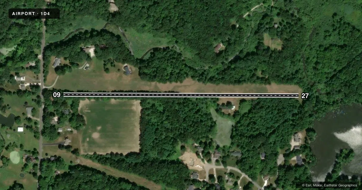
Airport sketch
Runways drawn to scale from FAA survey coordinates, rendered over satellite imagery. Not for navigation.
Approaches & charts
Services on the field
Fuel grades, oxygen, maintenance, ramp storage and lighting — as declared to the FAA by the airport operator.
Fuel & services
- Fuel
- Not available
- Oxygen (bottled)
- Not available
- Oxygen (bulk)
- Not available
- Airframe repair
- Not available
- Power plant repair
- Not available
Ramp & ground
- Transient storage
- Not published
- Landing fee
- Yes
- Customs
- Not available
- Segmented circle
- No
Fuel & FBOs
Cheapest 100LL and Jet A on the field and nearby. Always confirm with the FBO before taxi.
Airport notes
Surface conditions, obstructions, local procedures, lighting outages and other notes published with each FAA cycle.
General notes
- FOR CD CTC CLEVELAND APCH AT 216-352-2323, WHEN APCH CLSD CTC CLEVELAND ARTCC AT 440-774-0223/0490.
- DEER, BIRDS, & WILDLIFE ON & INVOF ARPT.
- OPEN TO THE PUB, WX AND CONDS PMTG. LDG FEES. NO PRKG, FEES MAY APPLY. NO UAS OR SIMILAR ACFT PMTD.
- NO UNAUTH VEHICLES. NO TRESPASSING.
- STUDENT OPS NA; NGT OPS NA.
Approach & departure obstructions
- 09THR & DTHR MRKGS NOT VSB FM 1000 FT AGL; NO BDRY MKRS.
- 27THR & DTHR MRKGS NOT VSB FM 1000 FT AGL; NO BDRY MKRS.
- 09YELLOW TIRES & CONES AT RWY END & DTHR ONLY.
- 27YELLOW TIRES & CONES AT RWY END & DTHR ONLY.
- 09OBSTN CLNC SLP 0:1 TO DTHR OVR 75 FT TREES, 0 FT DIST, 75 FT L.
- 27OBSTN CLNC SLP 0:1 TO DTHR OVR 65 FT TREES, 0 FT DIST, 75 FT R.
Other notes
- 09/27ROLLING TRRN UPSLP TO THE WEST; WEST END 12 FT HYR THAN EAST END.
VFR map & nearby airports
VFR sectional. Tap any ICAO chip to open that airport.
Key facts · 1D4
Answer card- ICAO
- 1D4
- Name
- MAYFIELD
- Location
- AKRON, OHIO
- Elevation
- 1,100 ft MSL
- Traffic pattern altitude
- 2,100 ft MSL (1,000 AGL)
- Control tower
- Non-towered (use CTAF)
- Total runways
- 1
- Longest runway
- 09/27 · 2,315 ft
- Published ILS approaches
- 0
- Published frequencies
- 1
- Magnetic variation
- 7°
- Current flight rules
- MVFR
- Current wind
- 310° at 9 kt
- Favored runway now
- RWY 27
MAYFIELD is in Akron, Ohio. The field elevation is 1,100 ft MSL. It has one runway. Runway 09/27 is 2,315 ft long and is turf. The airport is not towered. CTAF is 122.9.
No ILS approaches are published here. Pattern altitude is not published, so use the standard 1,000 ft AGL for light piston operations unless the current FAA Chart Supplement says otherwise. That puts the pattern at about 2,100 ft MSL based on the listed field elevation. The runway slopes up to the west. The west end is 12 ft higher than the east end. Threshold and displaced threshold markings are not visible from 1,000 ft AGL. Yellow tires and cones mark the runway end and displaced threshold.
There are no on-field FBOs listed in the facts. FBO options vary. Contact the airport operator directly before arrival. Or call the field on CTAF for current FBO availability. Published remarks also say student operations are not authorized. Night operations are not authorized. Deer, birds and other wildlife are reported on and near the airport. Clearance delivery is handled through Cleveland Approach when available. Check the current FAA Chart Supplement for any published noise or curfew restrictions before flying into the field.