METAR & TAF 2D1
2D1 does not publish a METAR.
Showing the nearest reporting station: KCAK (AKRON-CANTON RGNL) · 16.0 NM away. Conditions at 2D1 may differ.
METAR · KCAK
Observed 14:51Z
KCAK 271451Z 28011KT 10SM SCT021 SCT200 BKN250 26/21 A2992 RMK AO2 SLP124 T02610206 51000 $
- Wind
- 280° @ 11 kt
- Visibility
- 10 SM
- Temp / Dew
- 26°C / 21°C
- Altimeter
- 29.92 inHg
- Clouds
- BKN
- Density alt
- 2,637 ft
- Ceiling
- 25,000 ft AGL
- Rules
- VFR
Airport info & contacts
Manager on record, flight service, ARTCC, attendance schedule and pattern altitude — published by the FAA and refreshed every 28 days.
Location
- From city
- 3 NM N
- VFR sectional
- DETROIT
- ARTCC
- ZOB · CLEVELAND
- NOTAM facility
- CLE (NOTAM-D)
Airport manager
- Name
- JAMES LEE BROGAN
- Phone
- 330-356-9005
- Address
- 5247 LIMERICK AVE NW, NORTH CANTON OH 44720-7442
Flight service · Hours
- FSS CLE
- CLEVELAND1-800-WX-BRIEF
- Attendance
- 0800-DUSK
Frequencies
Tap any row to copy the frequency to your clipboard.
Runways & pattern
Full pagePattern entry · RWY 27
LEFT TRAFFIC| Runway | Heading (°M) | Length | Surface | Traffic |
|---|---|---|---|---|
| 18/36 | 173° / 353° | 3,500 ft | TURF | Standard L |
| 09/27Favored | 84° / 264° | 2,088 ft | TURF | Standard L |
Runway end performance
| End | TORA | TODA | ASDA | LDA | VGSI | Approach lights | Obstruction |
|---|---|---|---|---|---|---|---|
| 18 | — | — | — | — | — | — | 15', road, 20' from thr, 125' R of cntrln, slope 1 |
| 36 | — | — | — | — | — | — | 3', crops, 0' from thr, 40' R of cntrln, slope 0 |
| 09 | — | — | — | — | — | — | 25', pline, 35' from thr, 60' R of cntrln, slope 1 |
| 27 | — | — | — | — | — | — | 55', trees, 0' from thr, 110' R of cntrln, slope 0 |
Declared distances in feet. TORA = takeoff run available, TODA = takeoff distance, ASDA = accelerate-stop, LDA = landing distance.
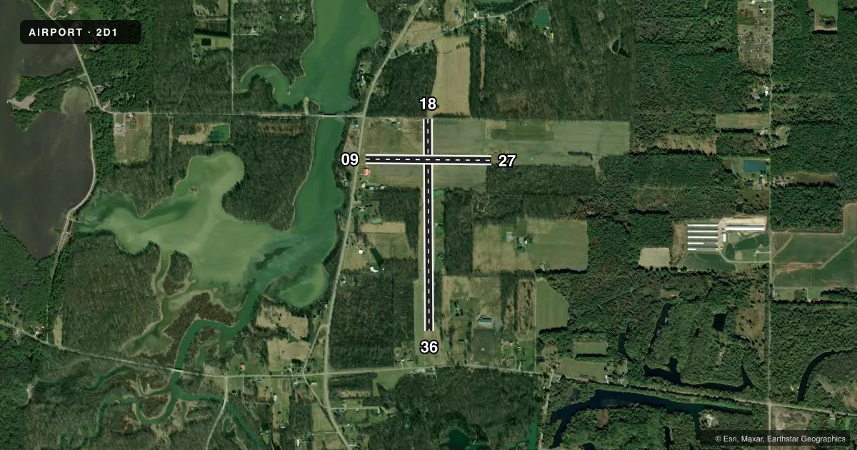
Airport sketch
Runways drawn to scale from FAA survey coordinates, rendered over satellite imagery. Not for navigation.
Approaches & charts
Services on the field
Fuel grades, oxygen, maintenance, ramp storage and lighting — as declared to the FAA by the airport operator.
Fuel & services
- Fuel
- Not available
- Oxygen (bottled)
- Not available
- Oxygen (bulk)
- Not available
- Airframe repair
- Not available
- Power plant repair
- Not available
- Other services
- PAJA
Ramp & ground
- Transient storage
- Tie-down
- Hangar
- Landing fee
- No fee published
- Customs
- Not available
- Wind indicator
- Yes
- Segmented circle
- No
Fuel & FBOs
Cheapest 100LL and Jet A on the field and nearby. Always confirm with the FBO before taxi.
Airport notes
Surface conditions, obstructions, local procedures, lighting outages and other notes published with each FAA cycle.
General notes
- AEROBATIC PRACTICE AREA WI 1 NM SFC-5000 FT MSL, HRS IREG, CHECK NOTAMS.
- OCNL GND LVL AEROBATIC PRACTICE.
- UAS OPS IN AREA MNT CTAF.
- PPR FOR WINTER OPS - CTC AMGR.
- PJE ON & WI 5 NM OF ARPT SFC-FL180, CHECK CAK APCH & MNT CTAF.
- DEER, BIRDS, & WILDLIFE ON & INVOF ARPT.
- FOR CD CTC CLEVELAND APCH AT 216-352-2323, WHEN APCH CLSD CTC CLEVELAND ARTCC AT 440-774-0223/0490.
- NGT OPS NA.
Approach & departure obstructions
- 09CONES.
- 18CONES.
- 27CONES.
- 36CONES.
- 09OBSTN CLNC SLP 1:1 OVR 25 FT FONE POLE/LINE, 35 FT DIST, 125 FT B.
- 18OBSTN CLNC SLP 1:1 OVR +15 FT ROAD, 20 FT DIST, 125 FT L/R.
- 27OBSTN CLNC SLP 0:1 OVR 55 FT TREES, 0 FT DIST, 110 FT L.
- 36OBSTN CLNC SLP 0:1 OVR 3 FT CROPS, 0 FT DIST, 40 FT L.
Other notes
- ESTABD BFR 1959.
- PRIOR CDN RQRD FOR TSNT HNGR.
- PRIOR CDN RQRD FOR TSNT TIEDOWN, NO ANCHORS/ROPES.
- 09/27MINOR RUTS & HUMPS FULL LEN.
- 18/36MINOR RUTS & HUMPS FULL LEN.
- 09/27SOFT DURG SPRING & WHEN WET.
- 18/36SOFT DURG SPRING & WHEN WET.
VFR map & nearby airports
VFR sectional. Tap any ICAO chip to open that airport.
Key facts · 2D1
Answer card- ICAO
- 2D1
- Name
- LEE FLD
- Location
- ALLIANCE, OHIO
- Elevation
- 1,062 ft MSL
- Traffic pattern altitude
- 2,062 ft MSL (1,000 AGL)
- Control tower
- Non-towered (use CTAF)
- Total runways
- 2
- Longest runway
- 18/36 · 3,500 ft
- Published ILS approaches
- 0
- Published frequencies
- 1
- Magnetic variation
- 7°
- Current flight rules
- VFR
- Current wind
- 280° at 11 kt
- Favored runway now
- RWY 27
Lee Field (2D1) sits in Alliance, Ohio at 1,062 ft MSL. It has two turf runways. The longest is 18/36 at 3,500 ft. The other runway is 09/27 at 2,088 ft. There is no control tower. CTAF is 122.9. No ILS approaches are published.
Pattern altitude is not published. Use 2,000 ft MSL for a standard 1,000 ft AGL pattern until you verify the current Chart Supplement or local procedure. The field is a good one to brief carefully before arrival. Published remarks call out cones on runway 09. They also note obstacle clearance issues near both ends of 18/36. Runway 18/36 is soft during spring and when wet. Wildlife is present on and near the airport. Unmanned aircraft operations also occur in the area, so keep a sharp scan and stay on CTAF.
There is no on-field FBO listed. Prior coordination is required for transient tiedown. No anchors or ropes are permitted. Night operations are not authorized. For clearance delivery, the published remarks direct pilots to Cleveland Approach or Cleveland ARTCC when Approach is closed. If you are planning a first visit, check the current FAA Chart Supplement before you go. That is the place to confirm any current operating notes, since this field has several published surface and obstacle cautions.