METAR & TAF 3G6
3G6 does not publish a METAR.
Showing the nearest reporting station: KCAK (AKRON-CANTON RGNL) · 20.1 NM away. Conditions at 3G6 may differ.
METAR · KCAK
Observed 16:51Z
KCAK 271651Z 25011KT 10SM SCT032 BKN220 28/19 A2989 RMK AO2 SLP111 T02830189 $
- Wind
- 250° @ 11 kt
- Visibility
- 10 SM
- Temp / Dew
- 28°C / 19°C
- Altimeter
- 29.89 inHg
- Clouds
- BKN
- Density alt
- 3,070 ft
- Ceiling
- 22,000 ft AGL
- Rules
- VFR
Airport info & contacts
Manager on record, flight service, ARTCC, attendance schedule and pattern altitude — published by the FAA and refreshed every 28 days.
Location
- From city
- 1 NM SE
- VFR sectional
- DETROIT
- ARTCC
- ZOB · CLEVELAND
- NOTAM facility
- CLE (NOTAM-D)
Airport manager
- Name
- WAYNE HARTER JR
- Phone
- 330-428-1269
- Address
- 18330 STATE ROUTE 62, BELOIT OH 44609-9520
Flight service · Hours
- FSS CLE
- CLEVELAND1-800-WX-BRIEF
- Attendance
- Unattended
Frequencies
Tap any row to copy the frequency to your clipboard.
Runways & pattern
Full pagePattern entry · RWY 18
LEFT TRAFFICRunway end performance
| End | TORA | TODA | ASDA | LDA | VGSI | Approach lights | Obstruction |
|---|---|---|---|---|---|---|---|
| 36 | — | — | — | — | — | — | 18', pole, 315' from thr, 130' R of cntrln, slope 6 |
Declared distances in feet. TORA = takeoff run available, TODA = takeoff distance, ASDA = accelerate-stop, LDA = landing distance.
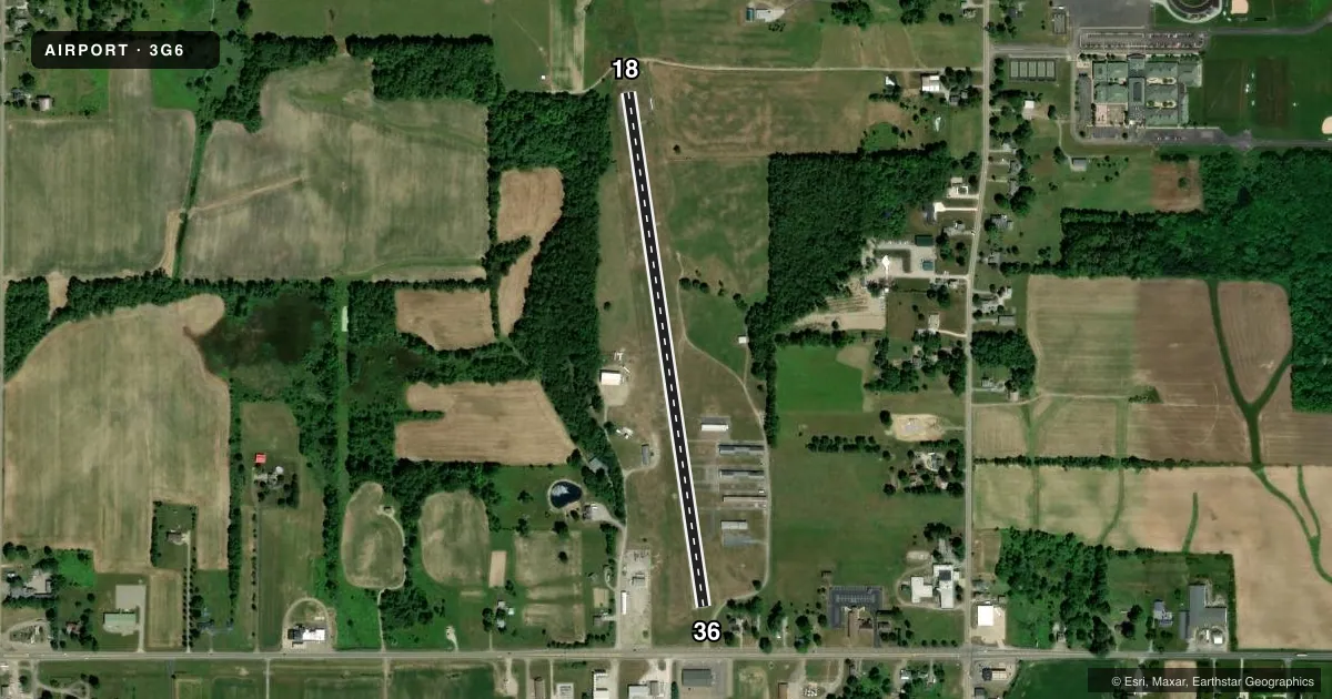
Airport sketch
Runways drawn to scale from FAA survey coordinates, rendered over satellite imagery. Not for navigation.
Approaches & charts
Services on the field
Fuel grades, oxygen, maintenance, ramp storage and lighting — as declared to the FAA by the airport operator.
Fuel & services
- Fuel
- 100LL
- Oxygen (bottled)
- Not available
- Oxygen (bulk)
- Not available
- Airframe repair
- Not available
- Power plant repair
- Not available
Ramp & ground
- Transient storage
- Tie-down
- Landing fee
- No fee published
- Lighting schedule
- SEE RMK
- Wind indicator
- Yes
- Segmented circle
- No
Fuel & FBOs
Cheapest 100LL and Jet A on the field and nearby. Always confirm with the FBO before taxi.
Airport notes
Surface conditions, obstructions, local procedures, lighting outages and other notes published with each FAA cycle.
General notes
- FOR CD CTC CLEVELAND APCH AT 216-352-2323, WHEN APCH CLSD CTC CLEVELAND ARTCC AT 440-774-0223/0490.
- DEER, BIRDS, & WILDLIFE ON & INVOF ARPT.
Lighting notes
- ACTVT NSTD LIRL RWY 18/36 - CTAF.
Fuel notes
- 100LLAVBL ON REQ CALL AMGR.
Runway surface & condition
- 18/36NSTD LIRL DUE TO LAYOUT, COLORS, & NON-FRANGIBLE FIXTURES.
Approach & departure obstructions
- 18+18 FT TREES, 46 FT DIST, 92 FT R; +5 FT TREES, 119 FT DIST, 34 FT R.
- 36+45 FT TREE, 188 FT DIST, 108 FT R.
- 18CNTRLN FADED.
- 36CNTRLN FADED.
- 18NSTD BASIC DUE TO NRS LAYOUT & SIZE.
- 36NSTD BASIC DUE TO NRS LAYOUT & SIZE.
Other notes
- THIS AIRPORT HAS BEEN SURVEYED BY THE NATIONAL GEODETIC SURVEY.
- ROPES NOT PRVDD.
- 18/36EXCESSIVE CRACKING, VEGETATION THRU CRACKS & JOINTS, & UNEVEN ROUGH PAVEMENT.
VFR map & nearby airports
VFR sectional. Tap any ICAO chip to open that airport.
Key facts · 3G6
Answer card- ICAO
- 3G6
- Name
- TRI-CITY
- Location
- SEBRING, OHIO
- Elevation
- 1,187.5 ft MSL
- Traffic pattern altitude
- 2,187.5 ft MSL (1,000 AGL)
- Control tower
- Non-towered (use CTAF)
- Total runways
- 1
- Longest runway
- 18/36 · 2,768 ft
- Published ILS approaches
- 0
- Published frequencies
- 3
- Magnetic variation
- 9°
- Current flight rules
- VFR
- Current wind
- 250° at 11 kt
- Favored runway now
- RWY 18
Tri-City (3G6) is in Sebring, Ohio. The field elevation is 1,187.5 ft MSL. It has one runway. Runway 18/36 is 2,768 ft long and asphalt. There is no control tower. Pattern altitude is not published. Use the standard 1,000 ft AGL pattern for light piston traffic unless the current Chart Supplement says otherwise.
No ILS approaches are published here. For clearance delivery, Cleveland Approach handles the airport when it is open. If Approach is closed, Cleveland ARTCC is the backup contact. The published frequencies are CTAF 122.9. Cleveland Approach and departure use 125.5 and 371.875. Tri-City Airport is the on-field FBO. It carries 100LL. Call ahead at (330) 938-1216 to confirm service before you launch.
A first-time pilot should pay close attention to the runway condition. The published remarks call out cracking, vegetation through the pavement and uneven rough sections on 18/36. There are also trees near both runway ends. Runway 18 has nonstandard basic markings. Runway 36 does too. The centerline at that end is faded. Activated low-intensity runway lights are controlled by CTAF. Deer, birds and other wildlife are reported on and near the airport. Keep a sharp scan on arrival and departure.