METAR & TAF 4G4
4G4 does not publish a METAR.
Showing the nearest reporting station: KUCP (NEW CASTLE MUNI) · 12.6 NM away. Conditions at 4G4 may differ.
METAR · KUCP
Observed 09:56Z
KUCP 270956Z AUTO 00000KT 3SM BR CLR 17/17 A2990 RMK AO2 SLP133 T01670167
- Wind
- 000° @ 0 kt
- Visibility
- 3 SM
- Temp / Dew
- 17°C / 17°C
- Altimeter
- 29.90 inHg
- Clouds
- CLR
- Density alt
- 1,591 ft
- Ceiling
- Unlimited
- Rules
- MVFR
Airport info & contacts
Manager on record, flight service, ARTCC, attendance schedule and pattern altitude — published by the FAA and refreshed every 28 days.
Location
- From city
- 8 NM S
- VFR sectional
- DETROIT
- ARTCC
- ZOB · CLEVELAND
- NOTAM facility
- CLE (NOTAM-D)
Airport manager
- Name
- MICHAEL E STANKO
- Phone
- 330-549-0337
- Address
- 10800 SHARROTT RD, NORTH LIMA OH 44452-9523
Flight service · Hours
- FSS CLE
- CLEVELAND1-800-WX-BRIEF
- Attendance
- 0730-1800
Frequencies
Tap any row to copy the frequency to your clipboard.
Runways & pattern
Full pagePattern entry · RWY 10
LEFT TRAFFICRunway end performance
| End | TORA | TODA | ASDA | LDA | VGSI | Approach lights | Obstruction |
|---|---|---|---|---|---|---|---|
| 10 | — | — | — | — | PAPI 2-box left | — | 85', trees, 201' from thr, 235' R of cntrln, slope 0 |
| 28 | — | — | — | — | PAPI 2-box left(3.75°) | — | 85', trees, 280' from thr, 240' R of cntrln, slope 0 |
Declared distances in feet. TORA = takeoff run available, TODA = takeoff distance, ASDA = accelerate-stop, LDA = landing distance.
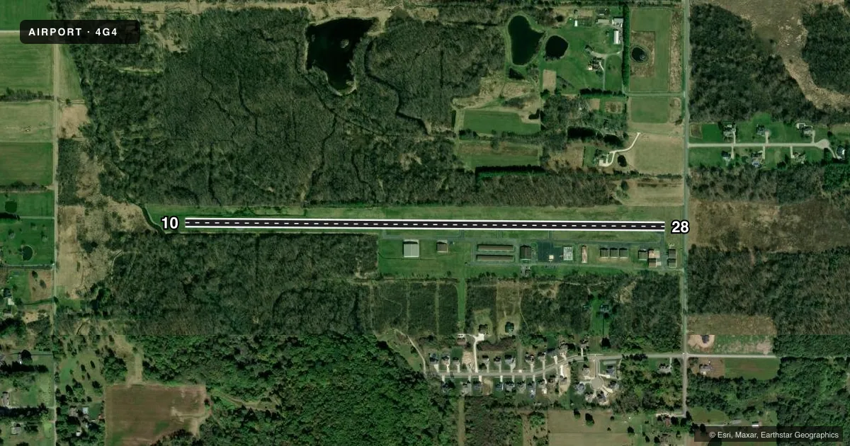
Airport sketch
Runways drawn to scale from FAA survey coordinates, rendered over satellite imagery. Not for navigation.
Approaches & charts
Services on the field
Fuel grades, oxygen, maintenance, ramp storage and lighting — as declared to the FAA by the airport operator.
Fuel & services
- Fuel
- 100LLA+
- Oxygen (bottled)
- Not available
- Oxygen (bulk)
- HIGH/LOW
- Airframe repair
- Major
- Power plant repair
- Major
- Other services
- AMB,INSTR,RNTL,SALES
Ramp & ground
- Transient storage
- Hangar
- Landing fee
- No fee published
- Customs
- Not available
- Lighting schedule
- SS-SR
- Beacon schedule
- SS-SR
- Beacon
- White / Green (civil land)(WG)
- Wind indicator
- Yes
- Segmented circle
- No
Fuel & FBOs
Cheapest 100LL and Jet A on the field and nearby. Always confirm with the FBO before taxi.
Airport notes
Surface conditions, obstructions, local procedures, lighting outages and other notes published with each FAA cycle.
General notes
- TWR 1085'AGL /2118'MSL/ LCTD 7-1/2 NM NNE.
- FOR CD CTC YOUNGSTOWN APCH AT 330-856-4806, WHEN APCH CLSD CTC CLEVELAND ARTCC AT 440-774-0223/0490.
Approach & departure obstructions
- 1040-80 FT TREES, 200 FT DIST, 135 FT L/R.
- 2830 FT FONE POLES, 200 FT DIST, 140 FT L & 190 FT R; 18 FT ROAD, 160 FT DIST, 250 FT L/R; 6 FT FENCE, 140 FT DIST, 100 FT L/R; 25 FT HNGRS, 45-100 FT DIST, 207 FT L.
- 10CALM WIND RWY.
- 10OBSTN CLNC SLP 0:1 TO DTHR OVR 40-80 FT TREES, 0-200 FT DIST, 135 FT L/R.
- 28OBSTN CLNC SLP 0:1 TO DTHR OVR 85 FT TREE, 215 FT DIST, 240 FT R; 30 FT FONE POLES, 200 FT DIST, 140 FT L & 190-FT R; 18 FT ROAD, 160 FT DIST, 250 FT L/R; 6 FT FENCE, 140 FT DIST, 100 FT L/R; 25 FT HNGRS, 45-100 FT DIST, 207 FT L.
Other notes
- ESTABD BFR 1959.
- PRIOR CDN RQRD FOR TSNT HNGR.
- 1UNATNDD EASTER, THANKSGIVING, & CHRISTMAS.
- 10/28LRG TRANSVERSE CTL CRACKS SPACED DOWN RWY.
VFR map & nearby airports
VFR sectional. Tap any ICAO chip to open that airport.
Key facts · 4G4
Answer card- ICAO
- 4G4
- Name
- YOUNGSTOWN ELSER METRO
- Location
- YOUNGSTOWN, OHIO
- Elevation
- 1,069.6 ft MSL
- Traffic pattern altitude
- 2,069.6 ft MSL (1,000 AGL)
- Control tower
- Non-towered (use CTAF)
- Total runways
- 1
- Longest runway
- 10/28 · 4,012 ft
- Published ILS approaches
- 0
- Published frequencies
- 5
- Magnetic variation
- 8°
- Current flight rules
- MVFR
- Current wind
- 000° at 0 kt
- Favored runway now
- –
Youngstown Elser Metro Airport sits in Youngstown, Ohio. The field elevation is 1,069.6 ft MSL. It has one runway, 10/28, which is 4,012 ft long. There is no control tower. The airport is unattended on Easter, Thanksgiving and Christmas. The runway environment has several published obstacles near both ends, so brief the departure and arrival path before you go. Runway 10 has trees close in on the approach side. Runway 28 has telephone poles, a road, a fence and hangars near the obstacle clearance surface. Large transverse centerline cracks are also published for runway 10/28, so expect a pavement condition check on rollout and takeoff.
No ILS approaches are published here. Pattern altitude is not published, so use the standard 1,000 ft AGL for light piston operations unless the current FAA Chart Supplement says otherwise. Gemco Aviation Services is on the field. It carries 100LL and Jet A Prist. For clearance delivery, contact Youngstown Approach at 330-856-4806. When approach is closed, contact Cleveland ARTCC. The tower is located 7.5 NM north-northeast of the airport. Calm wind runway is runway 10. If you need transient hangar space, prior coordination is required. This is a non-towered field with published approach and departure support. Expect to self-announce on CTAF and keep an eye out for local traffic.