METAR & TAF 02G
02G does not publish a METAR.
Showing the nearest reporting station: KBVI (BEAVER COUNTY) · 12.8 NM away. Conditions at 02G may differ.
METAR · KBVI
Observed 08:15Z
KBVI 270815Z AUTO 00000KT 10SM SCT075 21/19 A2990 RMK AO2 T02110190
- Wind
- 000° @ 0 kt
- Visibility
- 10 SM
- Temp / Dew
- 21°C / 19°C
- Altimeter
- 29.90 inHg
- Clouds
- SCT
- Density alt
- 2,184 ft
- Ceiling
- Unlimited
- Rules
- VFR
Airport info & contacts
Manager on record, flight service, ARTCC, attendance schedule and pattern altitude — published by the FAA and refreshed every 28 days.
Location
- From city
- 4 NM NW
- VFR sectional
- DETROIT
- ARTCC
- ZOB · CLEVELAND
- NOTAM facility
- CLE (NOTAM-D)
Airport manager
- Name
- JAMES PUSATERI
- Phone
- 330-397-5769
- Address
- PO BOX 81, EAST LIVERPOOL OH 43920-5081
Flight service · Hours
- FSS CLE
- CLEVELAND1-800-WX-BRIEF
- Attendance
- Unattended
Frequencies
Tap any row to copy the frequency to your clipboard.
Runways & pattern
Full pagePattern entry · RWY 07
LEFT TRAFFICRunway end performance
| End | TORA | TODA | ASDA | LDA | VGSI | Approach lights | Obstruction |
|---|---|---|---|---|---|---|---|
| 07 | — | — | — | — | — | — | 8', tree, 321' from thr, 58' R of cntrln, slope 15 |
| 25 | — | — | — | — | PAPI 4-box left(3°) | — | 60', trees, 1325' from thr, 105' R of cntrln, slope 18 |
Declared distances in feet. TORA = takeoff run available, TODA = takeoff distance, ASDA = accelerate-stop, LDA = landing distance.
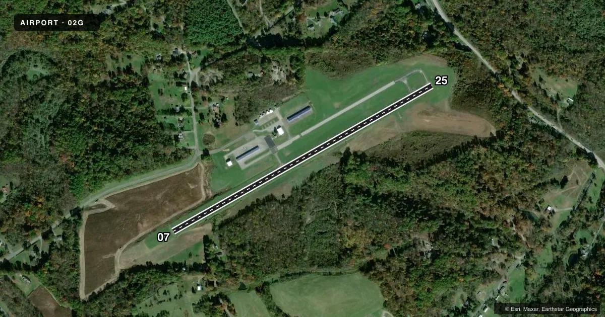
Airport sketch
Runways drawn to scale from FAA survey coordinates, rendered over satellite imagery. Not for navigation.
Approaches & charts
Services on the field
Fuel grades, oxygen, maintenance, ramp storage and lighting — as declared to the FAA by the airport operator.
Fuel & services
- Fuel
- 100LL
- Oxygen (bottled)
- Not available
- Oxygen (bulk)
- Not available
- Airframe repair
- Not available
- Power plant repair
- Not available
Ramp & ground
- Transient storage
- Tie-down
- Landing fee
- No fee published
- Customs
- Not available
- Lighting schedule
- SEE RMK
- Beacon schedule
- SS-SR
- Beacon
- White / Green (civil land)(WG)
- Wind indicator
- Lighted
- Segmented circle
- No
Fuel & FBOs
Cheapest 100LL and Jet A on the field and nearby. Always confirm with the FBO before taxi.
Airport notes
Surface conditions, obstructions, local procedures, lighting outages and other notes published with each FAA cycle.
General notes
- LGTD OBSTN HI TENSION LINE 1.5 NM NW.
- DEER, BIRDS, & OTR WILDLIFE ON & INVOF ARPT.
- FOR CD CTC PITTSBURGH APCH AT 412-472-5591.
Lighting notes
- ACTVT REIL RWY 07 & 25; PAPI RWY 25; MIRL RWY 07/25 - CTAF.
Fuel notes
- 100LL100LL AVBL H24 SELF SVC VIA CREDIT CARD.
Other notes
- ROPES NOT PRVDD.
VFR map & nearby airports
VFR sectional. Tap any ICAO chip to open that airport.
Key facts · 02G
Answer card- ICAO
- 02G
- Name
- COLUMBIANA COUNTY
- Location
- EAST LIVERPOOL, OHIO
- Elevation
- 1,160.5 ft MSL
- Traffic pattern altitude
- 2,160.5 ft MSL (1,000 AGL)
- Control tower
- Non-towered (use CTAF)
- Total runways
- 1
- Longest runway
- 07/25 · 3,503 ft
- Published ILS approaches
- 0
- Published frequencies
- 6
- Magnetic variation
- 8°
- Current flight rules
- VFR
- Current wind
- 000° at 0 kt
- Favored runway now
- –
Columbiana County Airport sits in East Liverpool, Ohio. The field elevation is 1,160.5 ft MSL. It has one runway. Runway 07/25 is 3,503 ft long with an asphalt surface. The airport is not towered. Pattern altitude is not published, so use the standard 1,000 ft AGL for light piston operations unless the current Chart Supplement says otherwise.
No ILS approaches are published here. The airport uses CTAF 123.0 and UNICOM 123.0. Pittsburgh Approach handles clearance delivery and approach or departure services on the published frequencies. For first-time arrivals, note the field sits in a busy Pittsburgh radar environment. Check the current Chart Supplement for any airspace or procedural details that affect your route.
Columbiana County Airport is the on-field FBO. It carries 100LL. The published remarks say 100LL is available 24 hours a day by self-service with a credit card. Runway end identifier lights are installed on 07 and 25. Medium intensity runway lights are also on both ends and are controlled by CTAF. The PAPI is on runway 25. Wildlife is a real factor here. Deer, birds and other wildlife are reported on and near the airport. A lighted high-tension line sits 1.5 NM northwest of the field, so keep that in mind on departure and arrival.