METAR & TAF 2G2
Current METAR
Observed 13:35Z
K2G2 271335Z AUTO 27005KT 10SM CLR 23/21 A2993 RMK A01
- Wind
- 270° @ 5 kt
- Visibility
- 10 SM
- Temp / Dew
- 23°C / 21°C
- Altimeter
- 29.93 inHg
- Clouds
- CLR
- Density alt
- 2,433 ft
- Ceiling
- Unlimited
- Rules
- VFR
Airport info & contacts
Manager on record, flight service, ARTCC, attendance schedule and pattern altitude — published by the FAA and refreshed every 28 days.
Location
- From city
- 4 NM W
- VFR sectional
- DETROIT
- ARTCC
- ZOB · CLEVELAND
- NOTAM facility
- 2G2 (NOTAM-D)
Airport manager
- Name
- BRIAN THAXTON
- Phone
- 740-264-5388
- Address
- 600 AIRPARK DR, WINTERSVILLE OH 43953-9237
Flight service · Hours
- FSS CLE
- CLEVELAND1-800-WX-BRIEF
- Attendance
- 0900-1700
Frequencies
Tap any row to copy the frequency to your clipboard.
Runways & pattern
Full pagePattern entry · RWY 32
LEFT TRAFFICRunway end performance
| End | TORA | TODA | ASDA | LDA | VGSI | Approach lights | Obstruction |
|---|---|---|---|---|---|---|---|
| 32 | — | — | — | — | PAPI 4-box left(3.6°) | — | 70', trees, 1514' from thr, 365' R of cntrln, slope 18 |
Declared distances in feet. TORA = takeoff run available, TODA = takeoff distance, ASDA = accelerate-stop, LDA = landing distance.
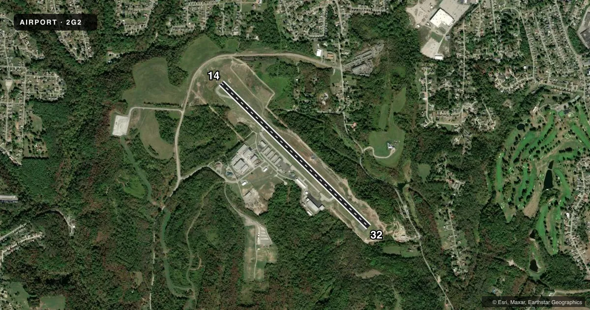
Airport sketch
Runways drawn to scale from FAA survey coordinates, rendered over satellite imagery. Not for navigation.
Approaches & charts
Services on the field
Fuel grades, oxygen, maintenance, ramp storage and lighting — as declared to the FAA by the airport operator.
Fuel & services
- Fuel
- 100LLAA+
- Oxygen (bottled)
- Not available
- Oxygen (bulk)
- Not available
- Airframe repair
- Minor
- Power plant repair
- Minor
- Other services
- AMB,INSTR
Ramp & ground
- Transient storage
- Tie-down
- Hangar
- Landing fee
- No fee published
- Customs
- Not available
- Lighting schedule
- SEE RMK
- Beacon schedule
- SS-SR
- Beacon
- White / Green (civil land)(WG)
- Wind indicator
- Lighted
- Segmented circle
- No
Fuel & FBOs
Cheapest 100LL and Jet A on the field and nearby. Always confirm with the FBO before taxi.
Airport notes
Surface conditions, obstructions, local procedures, lighting outages and other notes published with each FAA cycle.
General notes
- OCNL DEER, BIRDS, & OTR WILDLIFE ON & INVOF ARPT.
- FOR CD CTC PITTSBURGH APCH AT 412-472-5591.
Lighting notes
- ACTVT REIL RWY 14 & 32; MIRL RWY 14/32 - CTAF. PAPI RWY 32 OPR CONSLY.
Fuel notes
- 100LL100LL & JET A AVBL H24 VIA CREDIT CARD.
Other notes
- ESTABD BFR 1959.
- PPR FOR TSNT HNGR STORAGE.
- 1UNATNDD MAJOR HOLS.
VFR map & nearby airports
VFR sectional. Tap any ICAO chip to open that airport.
Key facts · 2G2
Answer card- ICAO
- 2G2
- Name
- GEARY A BATES/JEFFERSON COUNTY AIRPARK
- Location
- STEUBENVILLE, OHIO
- Elevation
- 1,198 ft MSL
- Traffic pattern altitude
- 2,198 ft MSL (1,000 AGL)
- Control tower
- Non-towered (use CTAF)
- Total runways
- 1
- Longest runway
- 14/32 · 5,001 ft
- Published ILS approaches
- 0
- Published frequencies
- 6
- Magnetic variation
- 8°
- Current flight rules
- VFR
- Current wind
- 270° at 5 kt
- Favored runway now
- RWY 32
Geary A Bates/Jefferson County Airpark is in Steubenville, Ohio. The field elevation is 1,198 ft MSL. It has one runway. Runway 14/32 is 5,001 ft of asphalt. There is no control tower. Pattern altitude is not published, so light piston traffic should plan on the standard 1,000 ft AGL unless the current Chart Supplement says otherwise.
No ILS approaches are published here. The airport uses CTAF 122.8 and UNICOM 122.8. Pittsburgh Approach handles the nearby approach and departure frequencies. For clearance delivery, contact Pittsburgh Approach at 412-472-5591.
Jefferson County Airpark is the on-field FBO. It carries 100LL, Jet A and Jet A Prist. Fuel is available 24 hours a day by credit card. Runway end identifier lights are on runways 14 and 32. Medium intensity runway lights are controlled on CTAF. The PAPI on runway 32 operates continuously.
A first-time arrival should watch for wildlife. Deer and birds have been reported on and near the airport. The field is unattended on major holidays. Prior permission is required for transient hangar storage. If you need current noise, curfew, or airspace details, check the current FAA Chart Supplement before you go.