METAR & TAF 2P7
2P7 does not publish a METAR.
Showing the nearest reporting station: KHLG (WHEELING OHIO COUNTY) · 16.2 NM away. Conditions at 2P7 may differ.
METAR · KHLG
Observed 12:24Z
KHLG 271224Z 27004KT 3SM BR SCT002 BKN032 20/19 A2994 RMK AO2 T02000194
- Wind
- 270° @ 4 kt
- Visibility
- 3 SM
- Temp / Dew
- 20°C / 19°C
- Altimeter
- 29.94 inHg
- Clouds
- BKN
- Density alt
- 2,046 ft
- Ceiling
- 3,200 ft AGL
- Rules
- MVFR
Airport info & contacts
Manager on record, flight service, ARTCC, attendance schedule and pattern altitude — published by the FAA and refreshed every 28 days.
Location
- From city
- 3 NM SW
- VFR sectional
- DETROIT
- ARTCC
- ZOB · CLEVELAND
- NOTAM facility
- CLE (NOTAM-D)
Airport manager
- Name
- LESLIE ALDERMAN
- Phone
- 740-695-0908
- Address
- 67160 AIRPORT RD, SAINT CLAIRSVILLE OH 43950-9469
Flight service · Hours
- FSS CLE
- CLEVELAND1-800-WX-BRIEF
- Attendance
- 0800-DUSK
Frequencies
Tap any row to copy the frequency to your clipboard.
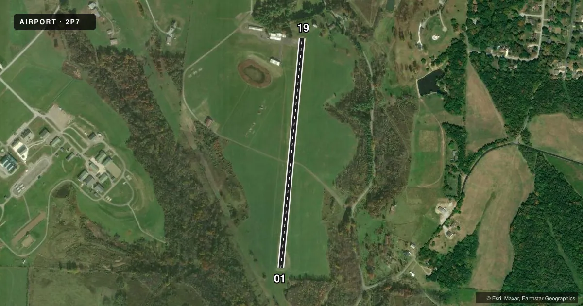
Runways & pattern
Full pagePattern entry · RWY 19
LEFT TRAFFICRunway end performance
| End | TORA | TODA | ASDA | LDA | VGSI | Approach lights | Obstruction |
|---|---|---|---|---|---|---|---|
| 01 | — | — | — | — | — | — | 30', trees, 293' from thr, 87' R of cntrln, slope 3 |
| 19 | — | — | — | — | — | — | 61', trees, 339' from thr, 125' R of cntrln, slope 2 |
Declared distances in feet. TORA = takeoff run available, TODA = takeoff distance, ASDA = accelerate-stop, LDA = landing distance.
Airport sketch
Runways drawn to scale from FAA survey coordinates, rendered over satellite imagery. Not for navigation.
Approaches & charts
Services on the field
Fuel grades, oxygen, maintenance, ramp storage and lighting — as declared to the FAA by the airport operator.
Fuel & services
- Fuel
- Not available
- Oxygen (bottled)
- Not available
- Oxygen (bulk)
- Not available
- Airframe repair
- Not available
- Power plant repair
- Not available
Ramp & ground
- Transient storage
- Tie-down
- Hangar
- Landing fee
- Yes
- Lighting schedule
- SEE RMK
- Beacon schedule
- SEE RMK
- Beacon
- White / Green (civil land)(WG)
- Wind indicator
- Yes
- Segmented circle
- No
Fuel & FBOs
Cheapest 100LL and Jet A on the field and nearby. Always confirm with the FBO before taxi.
Airport notes
Surface conditions, obstructions, local procedures, lighting outages and other notes published with each FAA cycle.
General notes
- SOUTH HALF OF RAMP IN POOR COND DUE TO BROKEN PAVEMENT.
- OCNL DEER, BIRDS, & OTR WILDLIFE ON & INVOF ARPT.
- FOR CD CTC CLEVELAND ARTCC AT 440-774-0226/0490.
Lighting notes
- ACTVT ABN - 123.3 OR CALL AMGR.
- ACTVT NSTD LIRL RWY 01/19 - 123.3 OR CALL AMGR.
Runway surface & condition
- 01/19NSTD LIRL DUE TO 15 FT FM EDGE OF PAVEMENT.
Approach & departure obstructions
- 01+30 FT TREES, 180-200 FT DIST, 120 FT R.
- 19+25 FT TREE, 175 FT DIST, 0-125 FT R; +10 FT BARN, 180 FT DIST, 120 FT L.
- 01FADED.
- 19FADED.
- 01NSTD BASIC DUE TO SML NRS & SML CNTRLN WITH NSTD SPACING.
- 19NSTD BASIC DUE TO SML NRS & SML CNTRLN WITH NSTD SPACING.
Other notes
- THIS AIRPORT HAS BEEN SURVEYED BY THE NATIONAL GEODETIC SURVEY.
- PRVDD OBSTS ARE LWRD/REMOVED SO AS TO PRVD A 20:1 APCH CLNC; AN OBST FREE PRI SFC 125 FT EACH SIDE OF CNTRLN IS MNTND.
- PRIOR CDN RQRD.
- ROPES NOT PRVDD.
- 01/19SFC IS WEATHERED W/SOME RAVELING, MED BLOCK CRACKING THROUGHOUT
VFR map & nearby airports
VFR sectional. Tap any ICAO chip to open that airport.
Key facts · 2P7
Answer card- ICAO
- 2P7
- Name
- ALDERMAN
- Location
- ST CLAIRSVILLE, OHIO
- Elevation
- 1,186.5 ft MSL
- Traffic pattern altitude
- 2,186.5 ft MSL (1,000 AGL)
- Control tower
- Non-towered (use CTAF)
- Total runways
- 1
- Longest runway
- 01/19 · 2,840 ft
- Published ILS approaches
- 0
- Published frequencies
- 1
- Magnetic variation
- 8°
- Current flight rules
- MVFR
- Current wind
- 270° at 4 kt
- Favored runway now
- RWY 19
Alderman Airport sits in St Clairsville, Ohio. Field elevation is 1,186.5 ft MSL. The airport has one runway. Runway 01/19 is 2,840 ft long and asphalt. It is a non-towered field. CTAF is 122.9. No ILS approaches are published here.
Pattern altitude is not published. Use 1,000 ft AGL as the standard light-piston pattern unless the current Chart Supplement or airport operator says otherwise. The runway has several published notes that matter on a first visit. Runway markings are nonstandard in places. Runway 01 markings are faded. The runway surface is weathered with some raveling and medium block cracking throughout. Runway 19 has trees and a barn near the end of the runway. Runway 01 has trees near its departure end. Wildlife is also reported on and near the airport.
There are no on-field FBOs listed in the facts. Prior coordination is required. For clearance delivery, contact Cleveland ARTCC at the numbers in the Chart Supplement. An activated beacon is available on 123.3 or by calling the airport manager. The field has runway lighting, but it is described as nonstandard low intensity because it sits 15 ft from the edge of pavement. Plan a careful look at the runway environment before you commit.