METAR & TAF 6G5
6G5 does not publish a METAR.
Showing the nearest reporting station: KCDI (CAMBRIDGE MUNI) · 17.8 NM away. Conditions at 6G5 may differ.
METAR · KCDI
Observed 17:15Z
KCDI 271715Z AUTO 24004KT 10SM BKN030 BKN039 28/22 A2991 RMK AO2 T02770217
- Wind
- 240° @ 4 kt
- Visibility
- 10 SM
- Temp / Dew
- 28°C / 22°C
- Altimeter
- 29.91 inHg
- Clouds
- BKN
- Density alt
- 3,200 ft
- Ceiling
- 3,000 ft AGL
- Rules
- MVFR
Airport info & contacts
Manager on record, flight service, ARTCC, attendance schedule and pattern altitude — published by the FAA and refreshed every 28 days.
Location
- From city
- 1 NM NW
- VFR sectional
- DETROIT
- ARTCC
- ZOB · CLEVELAND
- NOTAM facility
- CLE (NOTAM-D)
Airport manager
- Name
- ALEX STEPHEN
- Phone
- 740-213-0902
- Address
- 62299 FAIRVIEW RD, BARNESVILLE OH 43713
Flight service · Hours
- FSS CLE
- CLEVELAND1-800-WX-BRIEF
- Attendance
- ON CALL
Frequencies
Tap any row to copy the frequency to your clipboard.
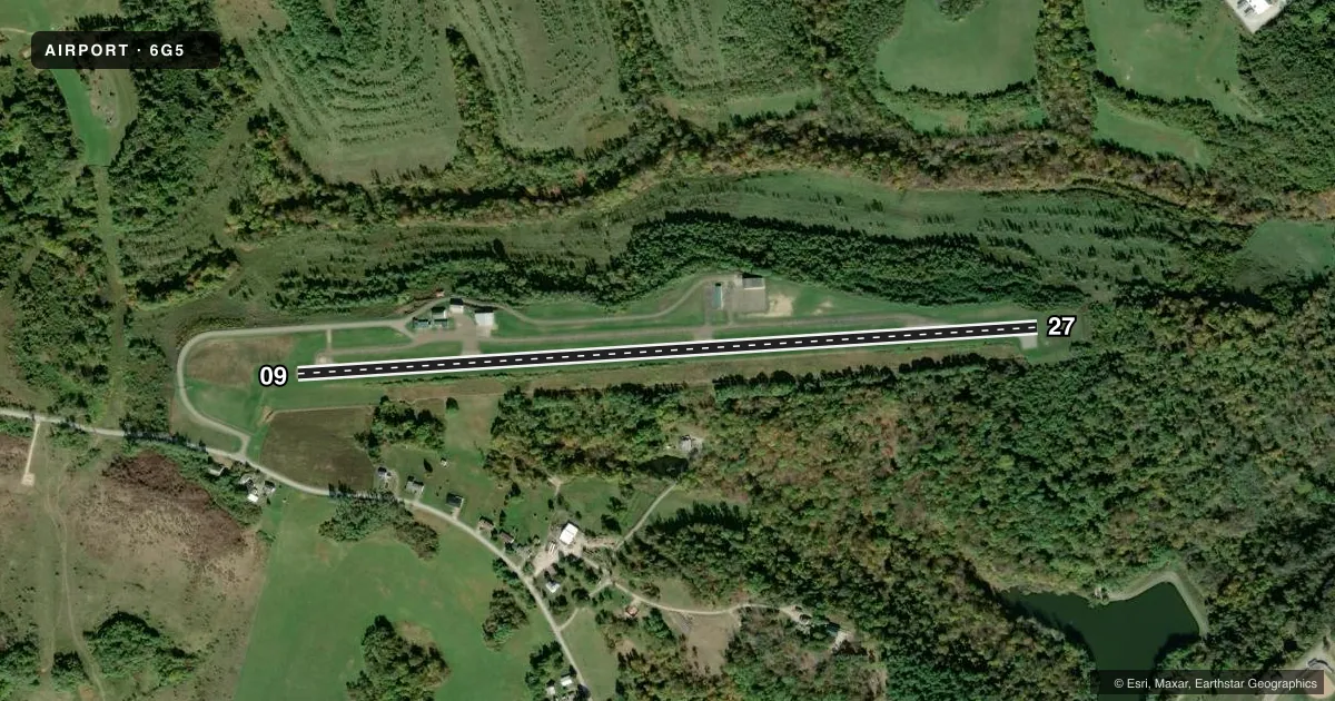
Runways & pattern
Full pagePattern entry · RWY 27
LEFT TRAFFICRunway end performance
| End | TORA | TODA | ASDA | LDA | VGSI | Approach lights | Obstruction |
|---|---|---|---|---|---|---|---|
| 27 | — | — | — | — | — | — | 5', trees, 201' from thr, 110' R of cntrln, slope 0 |
Declared distances in feet. TORA = takeoff run available, TODA = takeoff distance, ASDA = accelerate-stop, LDA = landing distance.
Airport sketch
Runways drawn to scale from FAA survey coordinates, rendered over satellite imagery. Not for navigation.
Approaches & charts
Services on the field
Fuel grades, oxygen, maintenance, ramp storage and lighting — as declared to the FAA by the airport operator.
Fuel & services
- Fuel
- 100LLA
- Oxygen (bottled)
- Not available
- Oxygen (bulk)
- Not available
- Airframe repair
- Not available
- Power plant repair
- Not available
Ramp & ground
- Transient storage
- Tie-down
- Hangar
- Landing fee
- No fee published
- Customs
- Not available
- Lighting schedule
- SEE RMK
- Beacon schedule
- SEE RMK
- Beacon
- White / Green (civil land)(WG)
- Wind indicator
- Yes
- Segmented circle
- No
Fuel & FBOs
Cheapest 100LL and Jet A on the field and nearby. Always confirm with the FBO before taxi.
Airport notes
Surface conditions, obstructions, local procedures, lighting outages and other notes published with each FAA cycle.
General notes
- BIRDS & OTR WILDLIFE ON & INVOF ARPT.
- FOR CD CTC CLEVELAND ARTCC AT 440-774-0226/0490.
- ARPT ACES CTLD BY GATE - CTC AMGR.
Lighting notes
- ACTVT ROTG BCN - CTAF.
- ACTVT REIL RWY 27; MIRL RWY 09/27 - CTAF.
Fuel notes
- 100LLFUEL AVBL H24 SELF SVC VIA CREDIT CARD.
Approach & departure obstructions
- 27+8-10 FT TREE/BRUSH, 200 FT DIST, 130 FT R; +8 FT FENCE, 200 FT DIST, 220 FT L.
- 09CTLG OBSTN EXCEEDS A 45 DEG SLP.
Other notes
- 2FOR SVC CALL AMGR.
VFR map & nearby airports
VFR sectional. Tap any ICAO chip to open that airport.
Key facts · 6G5
Answer card- ICAO
- 6G5
- Name
- BARNESVILLE/BRADFIELD
- Location
- BARNESVILLE, OHIO
- Elevation
- 1,312.3 ft MSL
- Traffic pattern altitude
- 2,312.3 ft MSL (1,000 AGL)
- Control tower
- Non-towered (use CTAF)
- Total runways
- 1
- Longest runway
- 09/27 · 4,003 ft
- Published ILS approaches
- 0
- Published frequencies
- 2
- Magnetic variation
- 8°
- Current flight rules
- MVFR
- Current wind
- 240° at 4 kt
- Favored runway now
- RWY 27
Barnesville/Bradfield Airport sits in Barnesville, Ohio. Field elevation is 1,312.3 ft MSL. The airport has one runway. Runway 09/27 is 4,003 ft of asphalt. There is no control tower. CTAF and UNICOM are both 123.0. No ILS approaches are published. Pattern altitude is not published, so use the standard 1,000 ft AGL for light piston traffic unless the current Chart Supplement says otherwise.
The on-field FBO is Barnesville-Bradfield Airport. It carries 100LL and Jet A. Fuel is available 24 hours a day self-serve by credit card. The airport remarks also note runway lighting on 09 and 27 is keyed to CTAF. Runway end identifier lights on 27 are also CTAF-activated. The rotating beacon is CTAF-activated too.
First-time pilots should pay attention to the published obstructions. There is a tree and brush near the 27 end, plus a fence left of the runway. The 09 end has cataloged obstacles that exceed a 45 degree slope. Birds and other wildlife are also reported on and near the field. Airport access is controlled by a gate. Contact the airport manager for access or service. For clearance delivery, use Cleveland ARTCC. Check the current Chart Supplement for any noise or curfew restrictions before flying in.