METAR & TAF KCDI
Current METAR
Observed 15:35Z
KCDI 271535Z AUTO 30005KT 10SM BKN024 BKN030 27/22 A2993 RMK AO2 T02650216
- Wind
- 300° @ 5 kt
- Visibility
- 10 SM
- Temp / Dew
- 27°C / 22°C
- Altimeter
- 29.93 inHg
- Clouds
- BKN
- Density alt
- 2,418 ft
- Ceiling
- 2,400 ft AGL
- Rules
- MVFR
Airport info & contacts
Manager on record, flight service, ARTCC, attendance schedule and pattern altitude — published by the FAA and refreshed every 28 days.
Location
- From city
- 3 NM S
- VFR sectional
- CINCINNATI
- ARTCC
- ZOB · CLEVELAND
- NOTAM facility
- CDI (NOTAM-D)
Airport manager
- Name
- DAVID GAL
- Phone
- 740-260-7558
- Address
- 9732 BRICK CHURCH RD, CAMBRIDGE OH 43725-9420
Flight service · Hours
- FSS CLE
- CLEVELAND1-800-WX-BRIEF
- Attendance
- MON-SAT · 0800-1700
Frequencies
Tap any row to copy the frequency to your clipboard.
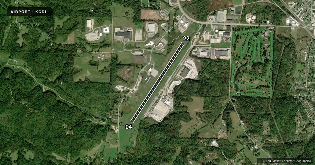
Runways & pattern
Full pagePattern entry · RWY 22
LEFT TRAFFICRunway end performance
| End | TORA | TODA | ASDA | LDA | VGSI | Approach lights | Obstruction |
|---|---|---|---|---|---|---|---|
| 04 | — | — | — | — | PAPI 4-box left(4°) | — | 50', pline, 795' from thr, 205' R of cntrln, slope 11 |
| 22 | — | — | — | — | PAPI 4-box right(3.55°) | — | 15', road, 355' from thr, 270' R of cntrln, slope 10 |
Declared distances in feet. TORA = takeoff run available, TODA = takeoff distance, ASDA = accelerate-stop, LDA = landing distance.
Airport sketch
Runways drawn to scale from FAA survey coordinates, rendered over satellite imagery. Not for navigation.
Approaches & charts
Services on the field
Fuel grades, oxygen, maintenance, ramp storage and lighting — as declared to the FAA by the airport operator.
Fuel & services
- Fuel
- 100LLA+
- Oxygen (bottled)
- Not available
- Oxygen (bulk)
- Not available
- Airframe repair
- Not available
- Power plant repair
- Not available
Ramp & ground
- Transient storage
- Tie-down
- Hangar
- Landing fee
- No fee published
- Customs
- Not available
- Lighting schedule
- SEE RMK
- Beacon schedule
- SS-SR
- Beacon
- White / Green (civil land)(WG)
- Wind indicator
- Lighted
- Segmented circle
- Yes
Fuel & FBOs
Cheapest 100LL and Jet A on the field and nearby. Always confirm with the FBO before taxi.
Airport notes
Surface conditions, obstructions, local procedures, lighting outages and other notes published with each FAA cycle.
General notes
- DEER, BIRDS, & OTR WILDLIFE INVOF ARPT.
- RAMP FEES FOR COML ACFT EXC FLT TRG ACFT, CDI BASED ACFT, OVNGT HNGR STAY, FUEL PURCHASE OF 25 GALS OR TOP OFF.
- FOR CD CTC CLEVELAND ARTCC AT 440-774-0226/0490.
Lighting notes
- ACTVT REIL RWY 04 & 22; MIRL RWY 04/22 - CTAF. PAPI RWY 04 & 22 OPR CONSLY.
Fuel notes
- 100LL100LL AVBL H24 SELF SVC VIA CREDIT CARD; FULL SVC AVBL WHEN ATNDD.
- A+JET A AVBL FULL SVC ONLY. FOR SVC AFT HRS CALL AMGR.
Approach & departure obstructions
- 04PAPI UNUSBL BYD 4 DEGS LEFT & 8 DEGS RIGHT OF CNTRLN.
- 22PAPI UNUSBL BYD 8 DEGS LEFT & 4 DEGS RIGHT OF CNTRLN.
- 04APCH SLP 10:1 TO DTHR OVR 65 FT TREE, 692 FT DIST, 330 FT L.
Other notes
- THIS AIRPORT HAS BEEN SURVEYED BY THE NATIONAL GEODETIC SURVEY.
- PPR.
- MANAGERCDIAIRPORT@GMAIL.COM.
VFR map & nearby airports
VFR sectional. Tap any ICAO chip to open that airport.
Key facts · KCDI
Answer card- ICAO
- KCDI
- Name
- CAMBRIDGE MUNI
- Location
- CAMBRIDGE, OHIO
- Elevation
- 798.8 ft MSL
- Traffic pattern altitude
- 1,798.8 ft MSL (1,000 AGL)
- Control tower
- Non-towered (use CTAF)
- Total runways
- 1
- Longest runway
- 04/22 · 4,298 ft
- Published ILS approaches
- 0
- Published frequencies
- 2
- Magnetic variation
- 7°
- Current flight rules
- MVFR
- Current wind
- 300° at 5 kt
- Favored runway now
- RWY 22
Cambridge Muni sits in Cambridge, Ohio. Field elevation is 798.8 ft MSL. The airport has one asphalt runway, 04/22, at 4,298 ft. There is no control tower. CTAF and UNICOM are both 123.075. No ILS approaches are published, so plan with the current chart and weather in mind.
Pattern altitude is not published. Use the standard 1,000 ft AGL pattern unless local procedures or current Chart Supplement remarks say otherwise. The field has runway lights on 04/22. REILs are installed on both ends. The PAPI is on both runways. The published remarks note limits on how far off centerline it remains usable. There is also a tree on the Runway 04 approach path, so pay attention to the displaced threshold and the visual glide path.
Cambridge Flight Center is on the field. It carries 100LL, Jet A and Jet A Prist. 100LL is available 24 hours a day self-serve by credit card. Jet A is full service only. Wildlife is a known factor here, so expect deer and birds in the area. This is a prior permission required airport. Check in with the airport manager before arrival if you are not already coordinated.