METAR & TAF 80G
80G does not publish a METAR.
Showing the nearest reporting station: KCDI (CAMBRIDGE MUNI) · 17.9 NM away. Conditions at 80G may differ.
METAR · KCDI
Observed 13:15Z
KCDI 271315Z AUTO 00000KT 10SM CLR 21/21 A2994 RMK AO2 T02120212
- Wind
- 000° @ 0 kt
- Visibility
- 10 SM
- Temp / Dew
- 21°C / 21°C
- Altimeter
- 29.94 inHg
- Clouds
- CLR
- Density alt
- 1,742 ft
- Ceiling
- Unlimited
- Rules
- VFR
Airport info & contacts
Manager on record, flight service, ARTCC, attendance schedule and pattern altitude — published by the FAA and refreshed every 28 days.
Location
- From city
- 2 NM SE
- VFR sectional
- DETROIT
- ARTCC
- ZID · INDIANAPOLIS
- NOTAM facility
- CLE (NOTAM-D)
Airport manager
- Name
- DAVID ZIMMER
- Phone
- 740-545-7580
- Address
- 20629 STATE ROUTE 93, WEST LAFAYETTE OH 43845-9786
Flight service · Hours
- FSS CLE
- CLEVELAND1-800-WX-BRIEF
- Attendance
- IREG
Frequencies
Tap any row to copy the frequency to your clipboard.
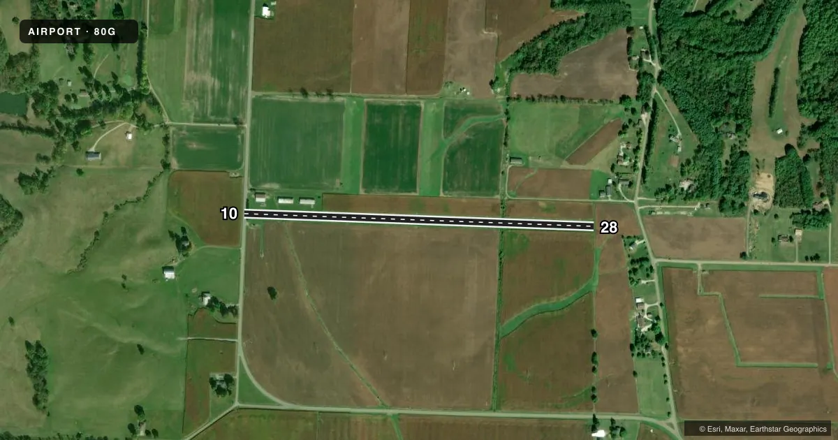
Runways & pattern
Full pagePattern entry · RWY 10
LEFT TRAFFICRunway end performance
| End | TORA | TODA | ASDA | LDA | VGSI | Approach lights | Obstruction |
|---|---|---|---|---|---|---|---|
| 10 | — | — | — | — | — | — | 25', pline, 0' from thr, 50' R of cntrln, slope 1 |
| 28 | — | — | — | — | — | — | 37', tree, 263' from thr, 89' R of cntrln, slope 7 |
Declared distances in feet. TORA = takeoff run available, TODA = takeoff distance, ASDA = accelerate-stop, LDA = landing distance.
Airport sketch
Runways drawn to scale from FAA survey coordinates, rendered over satellite imagery. Not for navigation.
Approaches & charts
Services on the field
Fuel grades, oxygen, maintenance, ramp storage and lighting — as declared to the FAA by the airport operator.
Fuel & services
- Fuel
- Not available
Ramp & ground
- Transient storage
- Not published
- Landing fee
- No fee published
- Wind indicator
- Yes
- Segmented circle
- No
Fuel & FBOs
Cheapest 100LL and Jet A on the field and nearby. Always confirm with the FBO before taxi.
Airport notes
Surface conditions, obstructions, local procedures, lighting outages and other notes published with each FAA cycle.
General notes
- FOR CD CTC INDIANAPOLIS ARTCC AT 317-247-2411.
Approach & departure obstructions
- 28DUE TO 280 FT HILLS, 2500 FT WSW.
- 10OBSTN CLNC SLP 18:1 TO DTHR.
- 10ALSO 270 FT WOODED HILL, 2100 FT DIST.
Other notes
- MANAGERCELL 740-545-7580.
VFR map & nearby airports
VFR sectional. Tap any ICAO chip to open that airport.
Key facts · 80G
Answer card- ICAO
- 80G
- Name
- TRI-CITY
- Location
- WEST LAFAYETTE, OHIO
- Elevation
- 844 ft MSL
- Traffic pattern altitude
- 1,844 ft MSL (1,000 AGL)
- Control tower
- Non-towered (use CTAF)
- Total runways
- 1
- Longest runway
- 10/28 · 3,000 ft
- Published ILS approaches
- 0
- Published frequencies
- 1
- Magnetic variation
- –
- Current flight rules
- VFR
- Current wind
- 000° at 0 kt
- Favored runway now
- –
Tri-City (80G) sits in West Lafayette, Ohio. Field elevation is 844 ft MSL. The airport has one runway. Runway 10/28 is 3,000 ft of turf, which is the longest runway on the field. No control tower is published, so use CTAF 122.9 for local traffic calls.
No ILS approaches are published here. Pattern altitude is not published in the facts, so use the current Chart Supplement before you go. The published remarks matter here. There is a 270-foot wooded hill about 2,100 feet from runway 10. There are also 280-foot hills about 2,500 feet west-southwest of the field. Right-hand traffic is in effect for runway 28. The obstacle clearance slope to the displaced threshold on runway 10 is 18 to 1.
No on-field FBOs are listed in the facts. Contact the airport operator directly or call the field on CTAF for current services before arrival. For clearance delivery, the published contact is Indianapolis ARTCC. If you are planning a first visit, pay close attention to the terrain around the field and the pattern direction on runway 28. Turf surface and nearby hills make a careful arrival brief worth doing before descent.