METAR & TAF 42I
42I does not publish a METAR.
Showing the nearest reporting station: KZZV (ZANESVILLE MUNI) · 6.7 NM away. Conditions at 42I may differ.
METAR · KZZV
Observed 13:14Z
KZZV 271314Z AUTO 21004KT 6SM BR SCT002 20/19 A2994 RMK AO2 T02000194
- Wind
- 210° @ 4 kt
- Visibility
- 6 SM
- Temp / Dew
- 20°C / 19°C
- Altimeter
- 29.94 inHg
- Clouds
- SCT
- Density alt
- 1,555 ft
- Ceiling
- Unlimited
- Rules
- VFR
Airport info & contacts
Manager on record, flight service, ARTCC, attendance schedule and pattern altitude — published by the FAA and refreshed every 28 days.
Location
- From city
- 4 NM N
- VFR sectional
- DETROIT
- ARTCC
- ZID · INDIANAPOLIS
- NOTAM facility
- CLE (NOTAM-D)
Airport manager
- Name
- ROBERT NORMAN
- Phone
- 740-454-1615
- Address
- 1200 FAIRVIEW RD, ZANESVILLE OH 43701-9729
Flight service · Hours
- FSS CLE
- CLEVELAND1-800-WX-BRIEF
- Attendance
- MON-SAT · 1000-DUSK
- SUN · 1200-DUSK
Frequencies
Tap any row to copy the frequency to your clipboard.
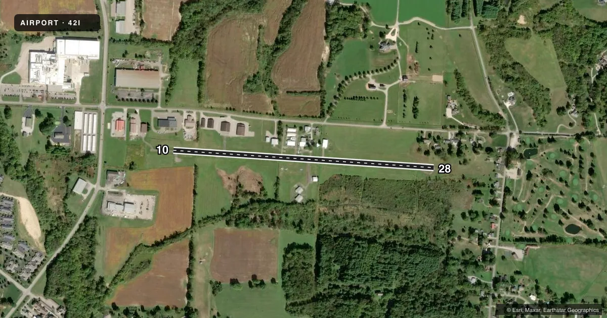
Runways & pattern
Full pagePattern entry · RWY 28
RIGHT TRAFFICRunway end performance
| End | TORA | TODA | ASDA | LDA | VGSI | Approach lights | Obstruction |
|---|---|---|---|---|---|---|---|
| 10 | — | — | — | — | — | — | 70', tree, 1010' from thr, 125' R of cntrln, slope 11 |
| 28 | — | — | — | — | — | — | 65', trees, 340' from thr, 90' R of cntrln, slope 2 |
Declared distances in feet. TORA = takeoff run available, TODA = takeoff distance, ASDA = accelerate-stop, LDA = landing distance.
Airport sketch
Runways drawn to scale from FAA survey coordinates, rendered over satellite imagery. Not for navigation.
Approaches & charts
Services on the field
Fuel grades, oxygen, maintenance, ramp storage and lighting — as declared to the FAA by the airport operator.
Fuel & services
- Fuel
- 100LL
- Oxygen (bottled)
- Not available
- Oxygen (bulk)
- Not available
- Airframe repair
- Major
- Power plant repair
- Major
- Other services
- INSTR,RNTL,SALES
Ramp & ground
- Transient storage
- Tie-down
- Lighting schedule
- SEE RMK
- Beacon schedule
- SEE RMK
- Beacon
- White / Green (civil land)(WG)
- Wind indicator
- Lighted
- Segmented circle
- No
Fuel & FBOs
Cheapest 100LL and Jet A on the field and nearby. Always confirm with the FBO before taxi.
Airport notes
Surface conditions, obstructions, local procedures, lighting outages and other notes published with each FAA cycle.
General notes
- DEER, BIRDS, & OTR WILDLIFE ON & INVOF ARPT.
- RWY 10 FIRST 280 FT OF PAVEMENT IS A TWY.
Lighting notes
- ACTVT ROTG BCN - CTAF (KEY MIKE 3X SLOWLY).
- ACTVT NSTD LIRL RWY 10/28 - CTAF (KEY MIKE 3X SLOWLY).
Fuel notes
- 100LLFULL SVC.
Runway surface & condition
- 10/28NSTD LIRL DUE TO OFF CNTR LCTN 50 FT NORTH & 30 FT SOUTH OF CNTRLN; RQRD TO KEY MIKE SLOWLY TO ACTVT.
Approach & departure obstructions
- 2850 FT TREES, 87 FT DIST, 117 FT R; 70 FT TREE, 167 FT DIST, 111 FT R.
- 10NSTD BASIC MRKGS DUE TO SOLID WHITE LN UNDER RWY NRS.
- 28NSTD BASIC MRKGS DUE TO SOLID WHITE LN UNDER RWY NRS.
Other notes
- VFR ONLY.
- PRIOR CDN RQRD FOR TSNT TIEDOWN, NO ROPES.
- 1UNATNDD MAJOR HOLS.
- OWNEROWNER RESIDES ADJ TO ARPT.
VFR map & nearby airports
VFR sectional. Tap any ICAO chip to open that airport.
Key facts · 42I
Answer card- ICAO
- 42I
- Name
- PARR
- Location
- ZANESVILLE, OHIO
- Elevation
- 790 ft MSL
- Traffic pattern altitude
- 1,790 ft MSL (1,000 AGL)
- Control tower
- Non-towered (use CTAF)
- Total runways
- 1
- Longest runway
- 10/28 · 3,100 ft
- Published ILS approaches
- 0
- Published frequencies
- 2
- Magnetic variation
- 6°
- Current flight rules
- VFR
- Current wind
- 210° at 4 kt
- Favored runway now
- RWY 28
PARR (42I) sits in Zanesville, Ohio. Field elevation is 790 ft MSL. The airport has one runway. Runway 10/28 is 3,100 ft long with asphalt pavement. There is no control tower. CTAF and UNICOM are both 122.8. No ILS approaches are published, so plan for VFR only operations here.
The pattern altitude is not published. Use the standard 1,000 ft AGL for light piston traffic unless the current Chart Supplement says otherwise. The field is unattended on major holidays. Full-service 100LL is available from Y-City Flying Service on the field. Call (740) 454-1615 if you need current fuel or ramp details.
This is a field where obstacle awareness matters. The published remarks call out trees near the runway environment. They also note a 3:1 approach slope on the 28 end because of a tall tree near the displaced threshold. Runway 10/28 also has nonstandard low-intensity lighting, with lights offset from the centerline. The airport beacon is activated by three slow clicks on CTAF. For clearance delivery, contact Indianapolis ARTCC at 317-247-2411. Check the current Chart Supplement before departure for any current restrictions or changes.