METAR & TAF I71
I71 does not publish a METAR.
Showing the nearest reporting station: KZZV (ZANESVILLE MUNI) · 17.9 NM away. Conditions at I71 may differ.
METAR · KZZV
Observed 13:14Z
KZZV 271314Z AUTO 21004KT 6SM BR SCT002 20/19 A2994 RMK AO2 T02000194
- Wind
- 210° @ 4 kt
- Visibility
- 6 SM
- Temp / Dew
- 20°C / 19°C
- Altimeter
- 29.94 inHg
- Clouds
- SCT
- Density alt
- 1,815 ft
- Ceiling
- Unlimited
- Rules
- VFR
Airport info & contacts
Manager on record, flight service, ARTCC, attendance schedule and pattern altitude — published by the FAA and refreshed every 28 days.
Location
- From city
- 3 NM E
- VFR sectional
- CINCINNATI
- Pattern altitude
- 800 ft AGL · 1,800 ft MSL
- ARTCC
- ZID · INDIANAPOLIS
- NOTAM facility
- CLE (NOTAM-D)
Airport manager
- Name
- KURT JOHNSON
- Phone
- 334-447-0624
- Address
- 995 E AIRPORT RD NE, MCCONNELLSVILLE OH 43756-9323
Flight service · Hours
- FSS CLE
- CLEVELAND1-800-WX-BRIEF
- Attendance
- Unattended
Frequencies
Tap any row to copy the frequency to your clipboard.
Runways & pattern
Full pagePattern entry · RWY 30
LEFT TRAFFICRunway end performance
| End | TORA | TODA | ASDA | LDA | VGSI | Approach lights | Obstruction |
|---|---|---|---|---|---|---|---|
| 12 | — | — | — | — | — | — | 25', road, 225' from thr, 125' R of cntrln, slope 1 |
| 30 | — | — | — | — | — | — | 6', hill, 250' from thr, 125' R of cntrln, slope 8 |
Declared distances in feet. TORA = takeoff run available, TODA = takeoff distance, ASDA = accelerate-stop, LDA = landing distance.
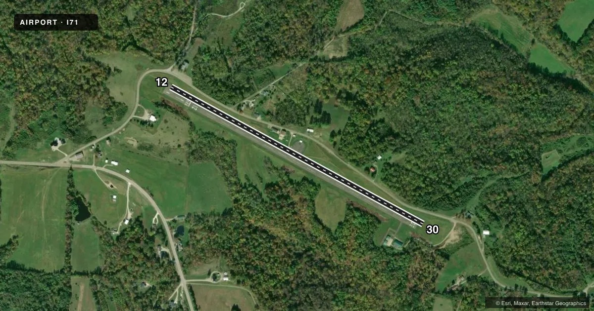
Airport sketch
Runways drawn to scale from FAA survey coordinates, rendered over satellite imagery. Not for navigation.
Approaches & charts
Services on the field
Fuel grades, oxygen, maintenance, ramp storage and lighting — as declared to the FAA by the airport operator.
Fuel & services
- Fuel
- 100LL
- Oxygen (bottled)
- Not available
- Oxygen (bulk)
- Not available
- Airframe repair
- Not available
- Power plant repair
- Not available
Ramp & ground
- Transient storage
- Tie-down
- Hangar
- Landing fee
- No fee published
- Customs
- Not available
- Lighting schedule
- SEE RMK
- Beacon schedule
- SS-SR
- Beacon
- White / Green (civil land)(WG)
- Wind indicator
- Lighted
- Segmented circle
- No
Fuel & FBOs
Cheapest 100LL and Jet A on the field and nearby. Always confirm with the FBO before taxi.
Airport notes
Surface conditions, obstructions, local procedures, lighting outages and other notes published with each FAA cycle.
General notes
- DEER ON & INVOF ARPT.
- FOR CD CTC INDIANAPOLIS ARTCC AT 317-247-2411.
Lighting notes
- ACTVT MIRL RWY 12/30 - CTAF.
Fuel notes
- 100LLFOR FUEL REFER TO LIST IN ADMIN BLDG.
Approach & departure obstructions
- 12+12 FT TRRN, 0 FT DIST, 125 FT L.
- 30+7 FT TRRN, 0 FT DIST, 125 FT R.
- 12APCH SLP 0:1 TO DTHR OVR 20 FT HILL, 0 FT DIST, 96 FT L.
- 30ALSO APCH SLP 17:1 OVR 74 FT TREES, 1527 FT DIST, 62 FT R.
Other notes
- VFR ONLY.
- PRIOR CDN RQRD.
- NO TIE DOWN ROPES.
- MANAGEREMERG TEL 740-962-3333-SHERIFF OFC.
VFR map & nearby airports
VFR sectional. Tap any ICAO chip to open that airport.
Key facts · I71
Answer card- ICAO
- I71
- Name
- MORGAN COUNTY
- Location
- MC CONNELSVILLE, OHIO
- Elevation
- 1,000 ft MSL
- Traffic pattern altitude
- 1,800 ft MSL (800 AGL)
- Control tower
- Non-towered (use CTAF)
- Total runways
- 1
- Longest runway
- 12/30 · 3,500 ft
- Published ILS approaches
- 0
- Published frequencies
- 2
- Magnetic variation
- 6°
- Current flight rules
- VFR
- Current wind
- 210° at 4 kt
- Favored runway now
- RWY 30
Morgan County Airport sits in Mc Connelsville, Ohio. Field elevation is 1,000 ft MSL. The airport has one runway. Runway 12/30 is 3,500 ft long with an asphalt surface. There is no control tower. CTAF and UNICOM are both 122.8. No ILS approaches are published here.
Pattern altitude is 800 ft AGL, which is 1,800 ft MSL. That matters here because the field has published obstructions near both runway ends. The Chart Supplement notes a hill and terrain near runway 12, plus trees and terrain near runway 30. Deer are also reported on and near the airport. This is a VFR-only field, so plan accordingly and give yourself room on arrival and departure.
Morgan County Airport has one on-field FBO listed as Morgan County Airport. It carries AVGAS 100LL. Fuel details are handled through the administration building. Medium intensity runway lights for 12/30 are pilot-controlled on the CTAF. Prior coordination is required before arrival. No tie down ropes are available. If you need current operating details, call the airport operator or the FBO directly by phone before you go.