METAR & TAF KUNI
Current METAR
Observed 13:15Z
KUNI 271315Z AUTO 00000KT 9SM FEW003 21/21 A2996 RMK AO2 T02100210
- Wind
- 000° @ 0 kt
- Visibility
- 9 SM
- Temp / Dew
- 21°C / 21°C
- Altimeter
- 29.96 inHg
- Clouds
- FEW
- Density alt
- 1,620 ft
- Ceiling
- Unlimited
- Rules
- VFR
Airport info & contacts
Manager on record, flight service, ARTCC, attendance schedule and pattern altitude — published by the FAA and refreshed every 28 days.
Location
- From city
- 10 NM SW
- VFR sectional
- CINCINNATI
- ARTCC
- ZID · INDIANAPOLIS
- NOTAM facility
- UNI (NOTAM-D)
Airport manager
- Name
- VICKI SMITH
- Phone
- 740-597-2600
- Address
- 747 COLUMBIA ROAD, ALBANY OH 45710
Flight service · Hours
- FSS DAY
- DAYTON1-800-WX-BRIEF
- Attendance
- ALL
Frequencies
Tap any row to copy the frequency to your clipboard.
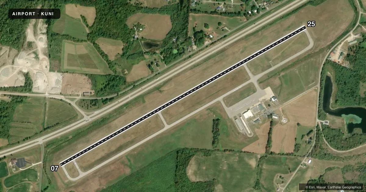
Runways & pattern
Full pagePattern entry · RWY 07
LEFT TRAFFICRunway end performance
| End | TORA | TODA | ASDA | LDA | VGSI | Approach lights | Obstruction |
|---|---|---|---|---|---|---|---|
| 07 | — | — | — | — | PAPI 4-box left(3°) | — | — |
| 25 | — | — | — | — | PAPI 4-box left(3°) | — | 51', tree, 1191' from thr, 301' R of cntrln, slope 19 |
Declared distances in feet. TORA = takeoff run available, TODA = takeoff distance, ASDA = accelerate-stop, LDA = landing distance.
Airport sketch
Runways drawn to scale from FAA survey coordinates, rendered over satellite imagery. Not for navigation.
Approaches & charts
ILS · 1
Services on the field
Fuel grades, oxygen, maintenance, ramp storage and lighting — as declared to the FAA by the airport operator.
Fuel & services
- Fuel
- 100LLA+
- Oxygen (bottled)
- Not available
- Oxygen (bulk)
- High pressure
- Airframe repair
- Major
- Power plant repair
- Major
- Other services
- INSTR
Ramp & ground
- Transient storage
- Tie-down
- Hangar
- Landing fee
- No fee published
- Customs
- Not available
- Lighting schedule
- SEE RMK
- Beacon schedule
- SS-SR
- Beacon
- White / Green (civil land)(WG)
- Wind indicator
- Lighted
- Segmented circle
- No
Fuel & FBOs
Cheapest 100LL and Jet A on the field and nearby. Always confirm with the FBO before taxi.
Airport notes
Surface conditions, obstructions, local procedures, lighting outages and other notes published with each FAA cycle.
General notes
- DEER, BIRDS, & OTR WILDLIFE ON & INVOF ARPT.
- RWY 07 & 25 LEFT TFC ONLY; EXTSV FLT TRNG; MAKE EVERY EFFORT TO OBS TPA & AVOID OVERFLIGHT OF NOISE SENSITIVE AREAS, CHURCH 1.8 MI NW OF RWY END 25 & VILLAGE OF ALBANY 2 MI EAST OF AER 25.
Lighting notes
- ACTVT REIL RWY 07 & 25; MIRL RWY 07/25 - CTAF. PAPI RWY 07 & 25 OPR CONSLY.
Fuel notes
- A+ICING INHIBITOR PREBLENDED.
Approach & departure obstructions
- 07LCTD 949 FT FM RWY END.
Other notes
- TPA TURBINE ACFR ( EXCEPT HELICOPTERS) 1534 AGL, MULTI ENGINE RECIP 1234 AGL, ALL OTHERS 1034 AGL.
- PRIOR CDN RQRD.
- MANAGERALTN CTCS: SHAWN WIRICK, 740-597-2600, WIRICK@OHIO.EDU; TODD MCGUIRE, 740-597-2609, MCGUIRET@OHIO.EDU.
- MANAGERFOR EMERG CALL 740-597-2600.
VFR map & nearby airports
VFR sectional. Tap any ICAO chip to open that airport.
Key facts · KUNI
Answer card- ICAO
- KUNI
- Name
- OHIO UNIVERSITY
- Location
- ATHENS/ALBANY, OHIO
- Elevation
- 765.7 ft MSL
- Traffic pattern altitude
- 1,765.7 ft MSL (1,000 AGL)
- Control tower
- Non-towered (use CTAF)
- Total runways
- 1
- Longest runway
- 07/25 · 5,600 ft
- Published ILS approaches
- 1
- Published frequencies
- 5
- Magnetic variation
- 6°
- Current flight rules
- VFR
- Current wind
- 000° at 0 kt
- Favored runway now
- –
Ohio University Airport (KUNI) sits in Athens/Albany, Ohio. Field elevation is 765.7 ft MSL. The airport has one runway, 07/25, which is 5,600 ft long with asphalt pavement. There is no control tower. The published ILS serves runway 25. Pattern altitude is not published as a single value. Use 1,034 ft AGL for most aircraft. Use 1,234 ft AGL for multi-engine reciprocating aircraft. Use 1,534 ft AGL for turbine aircraft except helicopters.
This is a training airport. Expect a lot of pattern work. Runways 07 and 25 require left traffic only. The Chart Supplement also calls out noise-sensitive areas near the field. Keep clear of the church 1.8 miles northwest of runway end 25. Stay away from the village of Albany 2 miles east of the airport off runway 25. Wildlife is also a factor here. Deer and birds are reported on and near the airport.
Ohio University Airport is the on-field FBO. It carries 100LL and Jet A with Prist. The fuel is preblended with icing inhibitor. Prior coordination is required before arrival. Runway end identifier lights and medium intensity runway lights are on runways 07 and 25. The PAPI on both ends operates continuously. For first-time arrivals, brief the left traffic pattern carefully and verify the current Chart Supplement before you go.