METAR & TAF KCYO
KCYO does not publish a METAR.
Showing the nearest reporting station: KRZT (ROSS COUNTY) · 4.9 NM away. Conditions at KCYO may differ.
METAR · KRZT
Observed 15:06Z
KRZT 271506Z AUTO 31003KT 10SM CLR 26/21 A2996 RMK AO2
- Wind
- 310° @ 3 kt
- Visibility
- 10 SM
- Temp / Dew
- 26°C / 21°C
- Altimeter
- 29.96 inHg
- Clouds
- CLR
- Density alt
- 2,120 ft
- Ceiling
- Unlimited
- Rules
- VFR
Airport info & contacts
Manager on record, flight service, ARTCC, attendance schedule and pattern altitude — published by the FAA and refreshed every 28 days.
Location
- From city
- 5 NM S
- VFR sectional
- CINCINNATI
- ARTCC
- ZID · INDIANAPOLIS
- NOTAM facility
- DAY (NOTAM-D)
Airport manager
- Name
- TIM WILSON
- Phone
- 740-474-5145
- Address
- 28181 MCCRADY RD, CIRCLEVILLE OH 43113-9725
Flight service · Hours
- FSS DAY
- DAYTON1-800-WX-BRIEF
- Attendance
- Unattended
Frequencies
Tap any row to copy the frequency to your clipboard.
Runways & pattern
Full pagePattern entry · RWY 01
LEFT TRAFFICRunway end performance
| End | TORA | TODA | ASDA | LDA | VGSI | Approach lights | Obstruction |
|---|---|---|---|---|---|---|---|
| 19 | — | — | — | — | PAPI 4-box right(3°) | — | — |
Declared distances in feet. TORA = takeoff run available, TODA = takeoff distance, ASDA = accelerate-stop, LDA = landing distance.
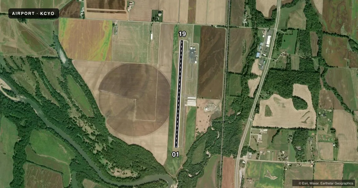
Airport sketch
Runways drawn to scale from FAA survey coordinates, rendered over satellite imagery. Not for navigation.
Approaches & charts
Services on the field
Fuel grades, oxygen, maintenance, ramp storage and lighting — as declared to the FAA by the airport operator.
Fuel & services
- Fuel
- 100LLA
- Oxygen (bottled)
- Not available
- Oxygen (bulk)
- Not available
- Airframe repair
- Not available
- Power plant repair
- Not available
Ramp & ground
- Transient storage
- Tie-down
- Landing fee
- No fee published
- Lighting schedule
- SEE RMK
- Beacon schedule
- SS-SR
- Beacon
- White / Green (civil land)(WG)
- Wind indicator
- Yes
- Segmented circle
- No
Fuel & FBOs
Cheapest 100LL and Jet A on the field and nearby. Always confirm with the FBO before taxi.
Airport notes
Surface conditions, obstructions, local procedures, lighting outages and other notes published with each FAA cycle.
General notes
- FOR CD CTC COLUMBUS APCH AT 614-338-8537.
Lighting notes
- ACTVT REIL RWY 19; PAPI RWY 19; MIRL RWY 01/19 - CTAF.
Fuel notes
- 100LL100LL & JET A AVBL H24 VIA CREDIT CARD.
Other notes
- MANAGERPICKAWAYCOUNTYAIRPORT@GMAIL.COM.
VFR map & nearby airports
VFR sectional. Tap any ICAO chip to open that airport.
Key facts · KCYO
Answer card- ICAO
- KCYO
- Name
- PICKAWAY COUNTY MEML
- Location
- CIRCLEVILLE, OHIO
- Elevation
- 684.8 ft MSL
- Traffic pattern altitude
- 1,684.8 ft MSL (1,000 AGL)
- Control tower
- Non-towered (use CTAF)
- Total runways
- 1
- Longest runway
- 01/19 · 4,346 ft
- Published ILS approaches
- 0
- Published frequencies
- 5
- Magnetic variation
- 5°
- Current flight rules
- VFR
- Current wind
- 310° at 3 kt
- Favored runway now
- RWY 01
Pickaway County Memorial Airport sits in Circleville, Ohio. The field elevation is 684.8 ft MSL. It has one runway, 01/19, which is 4,346 ft long. There is no control tower. Pattern altitude is not published, so a light piston pilot should verify the current traffic pattern in the FAA Chart Supplement before arrival.
No ILS approaches are published here. For IFR work, plan on using the current published procedures and coordinate with Columbus Approach as needed. The airport uses CTAF 122.7 and UNICOM 122.7. Clearance delivery is handled through Columbus Approach at 614-338-8537 when needed. Runway 19 has runway end identifier lights and a precision approach path indicator. Runways 01 and 19 have medium intensity runway lights. All lighting is controlled on the CTAF.
The on-field FBO is Pickaway County Memorial Airport. It carries 100LL and Jet A. Fuel is available 24 hours a day by credit card. The airport manager can be reached at pickawaycountyairport@gmail.com. For a first-time arrival, the main things to brief are the non-towered pattern, the published lighting setup and the lack of an ILS. Check the current FAA Chart Supplement for any additional local procedures before you go.