METAR & TAF KLHQ
Current METAR
Observed 15:53Z
KLHQ 271553Z AUTO 25005KT 10SM CLR 26/22 A2993 RMK AO2 SLP129 T02610217
- Wind
- 250° @ 5 kt
- Visibility
- 10 SM
- Temp / Dew
- 26°C / 22°C
- Altimeter
- 29.93 inHg
- Clouds
- CLR
- Density alt
- 2,384 ft
- Ceiling
- Unlimited
- Rules
- VFR
Airport info & contacts
Manager on record, flight service, ARTCC, attendance schedule and pattern altitude — published by the FAA and refreshed every 28 days.
Location
- From city
- 3 NM NW
- VFR sectional
- CINCINNATI
- ARTCC
- ZID · INDIANAPOLIS
- NOTAM facility
- LHQ (NOTAM-D)
Airport manager
- Name
- PAT ROONEY
- Phone
- 740-654-7001
- Address
- 3430 OLD COLUMBUS RD NW, CARROLL OH 43112-9674
Flight service · Hours
- FSS DAY
- DAYTON1-800-WX-BRIEF
- Attendance
- 0800-1800
Frequencies
Tap any row to copy the frequency to your clipboard.
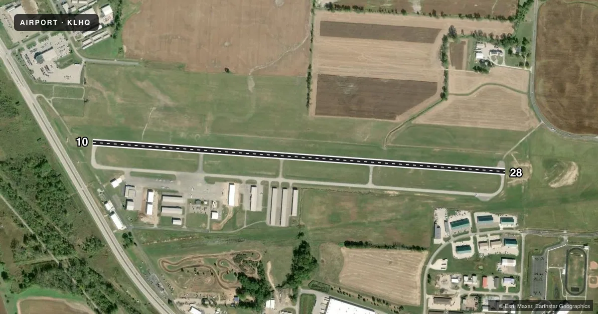
Runways & pattern
Full pagePattern entry · RWY 28
RIGHT TRAFFICRunway end performance
| End | TORA | TODA | ASDA | LDA | VGSI | Approach lights | Obstruction |
|---|---|---|---|---|---|---|---|
| 10 | — | — | — | — | PAPI 2-box left(3°) | — | 40', trees, 590' from thr, 300' R of cntrln, slope 9 |
| 28 | — | — | — | — | PAPI 2-box left(3.5°) | — | 5', gnd, 266' from thr, 182' R of cntrln, slope 13 |
Declared distances in feet. TORA = takeoff run available, TODA = takeoff distance, ASDA = accelerate-stop, LDA = landing distance.
Airport sketch
Runways drawn to scale from FAA survey coordinates, rendered over satellite imagery. Not for navigation.
Approaches & charts
Services on the field
Fuel grades, oxygen, maintenance, ramp storage and lighting — as declared to the FAA by the airport operator.
Fuel & services
- Fuel
- 100LLA+
- Oxygen (bottled)
- Not available
- Oxygen (bulk)
- Not available
- Airframe repair
- Major
- Power plant repair
- Major
- Other services
- INSTR,RNTL,SALES,SURV
Ramp & ground
- Transient storage
- Tie-down
- Hangar
- Landing fee
- No fee published
- Customs
- Not available
- Lighting schedule
- SEE RMK
- Beacon schedule
- SS-SR
- Beacon
- White / Green (civil land)(WG)
- Wind indicator
- Lighted
- Segmented circle
- No
Fuel & FBOs
Cheapest 100LL and Jet A on the field and nearby. Always confirm with the FBO before taxi.
Airport notes
Surface conditions, obstructions, local procedures, lighting outages and other notes published with each FAA cycle.
General notes
- OCNL DEER, BIRDS, & OTR WILDLIFE ON & INVOF ARPT.
- EXTSV FLT TRNG.
Lighting notes
- ACTVT REIL RWY 10 & 28; MIRL RWY 10/28 - CTAF. PAPI RWY 10 & 28 OPR CONSLY.
Approach & departure obstructions
- 10+5 FT BERM, 160 FT DIST, 110 FT R.
- 28CALM WIND RWY.
Other notes
- PRIOR CDN RQRD FOR TSNT HNGR.
- 1UNATNDD THANKSGIVING, CHRISTMAS, & NEW YEARS.
- MANAGERINFO@SUNDOWNERAVIATION.COM.
- MANAGEROR 740-475-8188.
VFR map & nearby airports
VFR sectional. Tap any ICAO chip to open that airport.
Key facts · KLHQ
Answer card- ICAO
- KLHQ
- Name
- FAIRFIELD COUNTY
- Location
- LANCASTER, OHIO
- Elevation
- 868.4 ft MSL
- Traffic pattern altitude
- 1,868.4 ft MSL (1,000 AGL)
- Control tower
- Non-towered (use CTAF)
- Total runways
- 1
- Longest runway
- 10/28 · 5,003 ft
- Published ILS approaches
- 0
- Published frequencies
- 6
- Magnetic variation
- 6°
- Current flight rules
- VFR
- Current wind
- 250° at 5 kt
- Favored runway now
- RWY 28
Fairfield County Airport (KLHQ) is in Lancaster, Ohio. The field elevation is 868.4 ft MSL. It has one runway. Runway 10/28 is 5,003 ft long with asphalt pavement. No tower is published, so expect non-towered operations on CTAF 122.725. The pattern altitude is not published. Use 1,000 ft AGL for light piston traffic unless local procedures or ATC say otherwise.
No ILS approaches are published here. The runway lighting is pilot-controlled on CTAF. PAPI is available on both runway ends. The calm wind runway is 28. A 5 ft berm sits 160 ft from the threshold and 110 ft right of runway 10, so give that end a close look on arrival and departure. Wildlife is also a factor here. Deer, birds and other traffic have been reported on and near the airport.
Sundowner Aviation is on the field. It carries 100LL and Jet A. Call the FBO directly at (740) 475-8188 for current service details. Prior coordination is required for transient hangar. The airport is unattended on Thanksgiving, Christmas and New Year's. Extensive flight training occurs here, so expect active pattern traffic and stay sharp on radio calls.