METAR & TAF KVTA
Current METAR
Observed 16:54Z
KVTA 271654Z AUTO 22004KT 10SM FEW028 27/22 A2991 RMK AO2 SLP120 T02720217
- Wind
- 220° @ 4 kt
- Visibility
- 10 SM
- Temp / Dew
- 27°C / 22°C
- Altimeter
- 29.91 inHg
- Clouds
- FEW
- Density alt
- 2,548 ft
- Ceiling
- Unlimited
- Rules
- VFR
Airport info & contacts
Manager on record, flight service, ARTCC, attendance schedule and pattern altitude — published by the FAA and refreshed every 28 days.
Location
- From city
- 3 NM SW
- VFR sectional
- DETROIT
- Pattern altitude
- 1,016 ft AGL · 1,900 ft MSL
- ARTCC
- ZID · INDIANAPOLIS
- NOTAM facility
- VTA (NOTAM-D)
Airport manager
- Name
- CAITLIN COPEN
- Phone
- 740-522-6968
- Address
- 530 HEATH RD, HEATH OH 43056-1134
Flight service · Hours
- FSS DAY
- DAYTON1-800-WX-BRIEF
- Attendance
- MON-SAT · 0800-1700
- SUN · 1200-1700
Frequencies
Tap any row to copy the frequency to your clipboard.
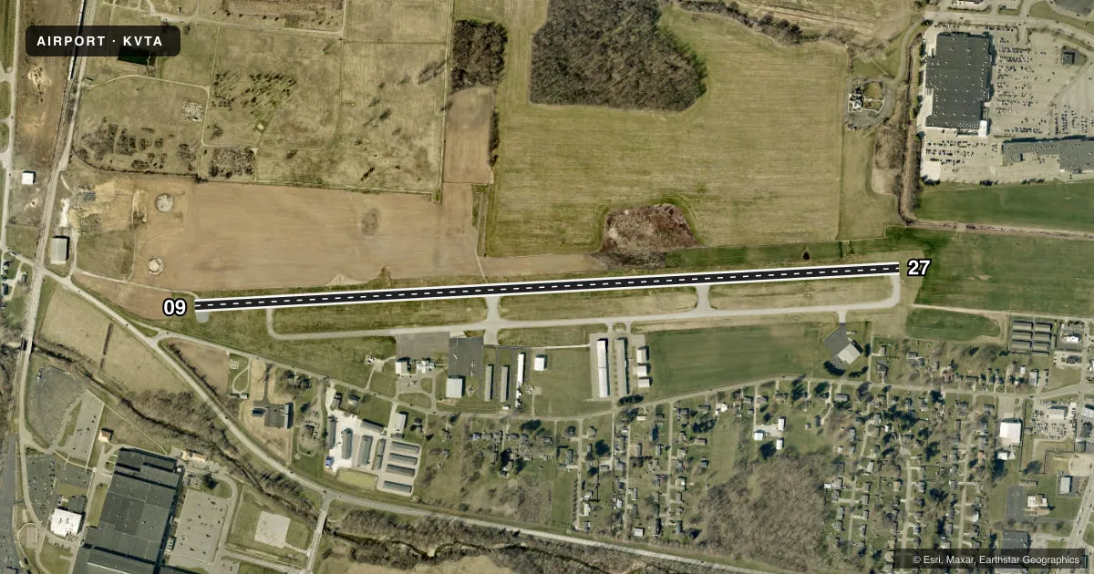
Runways & pattern
Full pagePattern entry · RWY 27
LEFT TRAFFICRunway end performance
| End | TORA | TODA | ASDA | LDA | VGSI | Approach lights | Obstruction |
|---|---|---|---|---|---|---|---|
| 09 | — | — | — | — | PAPI 4-box left(3°) | — | 15', road, 200' from thr, 168' R of cntrln, slope 0 |
| 27 | — | — | — | — | PAPI 4-box left(3.25°) | — | 4', berm, 200' from thr, 155' R of cntrln, slope 0 |
Declared distances in feet. TORA = takeoff run available, TODA = takeoff distance, ASDA = accelerate-stop, LDA = landing distance.
Airport sketch
Runways drawn to scale from FAA survey coordinates, rendered over satellite imagery. Not for navigation.
Approaches & charts
ILS · 1
Services on the field
Fuel grades, oxygen, maintenance, ramp storage and lighting — as declared to the FAA by the airport operator.
Fuel & services
- Fuel
- 100LLA1A1+
- Oxygen (bottled)
- Not available
- Oxygen (bulk)
- HIGH/LOW
- Airframe repair
- Major
- Power plant repair
- Major
- Other services
- INSTR,RNTL
Ramp & ground
- Transient storage
- Tie-down
- Hangar
- Landing fee
- Yes
- Customs
- Not available
- Lighting schedule
- SEE RMK
- Beacon schedule
- SS-SR
- Beacon
- White / Green (civil land)(WG)
- Wind indicator
- Lighted
- Segmented circle
- No
Fuel & FBOs
Cheapest 100LL and Jet A on the field and nearby. Always confirm with the FBO before taxi.
Airport notes
Surface conditions, obstructions, local procedures, lighting outages and other notes published with each FAA cycle.
General notes
- OCNL DEER, BIRDS, & OTR WILDLIFE ON & INVOF ARPT.
Lighting notes
- ACTVT OR INCR INTST REIL RWY 09 & 27; MIRL RWY 09/27 - 123.3. PAPI RWY 09 & 27 OPR CONSLY; MIRL RWY 09/27 OPR CONSLY LOW INTST.
Fuel notes
- 100LL100LL AVBL H24 VIA CREDIT CARD.
Approach & departure obstructions
- 09+15 FT ROAD, 0-200 FT DIST, 168-218 FT R; +11 FT FENCE, 0-200 FT DIST, 129-198 FT R.
- 27+5 FT BERM, 0-200 FT DIST, 155 FT L/R.
- 27CALM WIND RWY.
- 09APCH RATIO 0:1 OVR ROAD, 200 FT DIST, 168 FT R; APCH RATIO 17:1 TO DTHR OVR +15 FT ROAD, 258 FT DIST, 288 FT R.
- 27APCH RATIO 0:1 OVR +4 FT BERM, 200 FT DIST, 155 FT L.
Other notes
- LDG FEE FOR ACFT 10000 LB OR GTR - WAIVED WITH MNM FUEL PURCHASE.
VFR map & nearby airports
VFR sectional. Tap any ICAO chip to open that airport.
Key facts · KVTA
Answer card- ICAO
- KVTA
- Name
- LICKING COUNTY RGNL
- Location
- NEWARK, OHIO
- Elevation
- 883.8 ft MSL
- Traffic pattern altitude
- 1,899.8 ft MSL (1,016 AGL)
- Control tower
- Non-towered (use CTAF)
- Total runways
- 1
- Longest runway
- 09/27 · 4,649 ft
- Published ILS approaches
- 1
- Published frequencies
- 5
- Magnetic variation
- 6°
- Current flight rules
- VFR
- Current wind
- 220° at 4 kt
- Favored runway now
- RWY 27
Licking County Rgnl sits in Newark, Ohio. Field elevation is 883.8 ft MSL. The airport has one runway. Runway 09/27 is 4,649 ft long with asphalt pavement. There is no control tower. CTAF and UNICOM are both 122.7. Approach control is with Columbus on 125.95 or 317.775.
The published pattern altitude is 1,016 ft AGL. That puts the pattern at 1,899.8 ft MSL. Runway 09 has the published ILS approach. Runway 27 is listed as the calm wind runway. Aviation Works is on the field. It carries 100LL and Jet A Prist. 100LL is available 24 hours a day by credit card.
A first-time arrival should pay attention to the published obstacles near both runway ends. There is a berm near the 27 approach path. There are also roads and a fence near runway 09. Wildlife is also reported on and near the airport. The runway lights and PAPI operate continuously. If you are flying a heavier airplane, note that the landing fee for aircraft 10,000 pounds or greater is waived with a minimum fuel purchase. Check the current Chart Supplement for any changes before you go.