METAR & TAF 6G4
6G4 does not publish a METAR.
Showing the nearest reporting station: KVTA (LICKING COUNTY RGNL) · 20.5 NM away. Conditions at 6G4 may differ.
METAR · KVTA
Observed 12:54Z
KVTA 271254Z AUTO 00000KT 5SM BR CLR 20/19 A2994 RMK AO2 SLP133 T02000194
- Wind
- 000° @ 0 kt
- Visibility
- 5 SM
- Temp / Dew
- 20°C / 19°C
- Altimeter
- 29.94 inHg
- Clouds
- CLR
- Density alt
- 1,866 ft
- Ceiling
- Unlimited
- Rules
- MVFR
Airport info & contacts
Manager on record, flight service, ARTCC, attendance schedule and pattern altitude — published by the FAA and refreshed every 28 days.
Location
- From city
- 2 NM S
- VFR sectional
- DETROIT
- ARTCC
- ZID · INDIANAPOLIS
- NOTAM facility
- CLE (NOTAM-D)
Airport manager
- Name
- DOUG WHEELER
- Phone
- 740-398-8106
- Address
- 9051 GRANVILLE RD, MOUNT VERNON OH 43050-9411
Flight service · Hours
- FSS CLE
- CLEVELAND1-800-WX-BRIEF
- Attendance
- Unattended
Frequencies
Tap any row to copy the frequency to your clipboard.
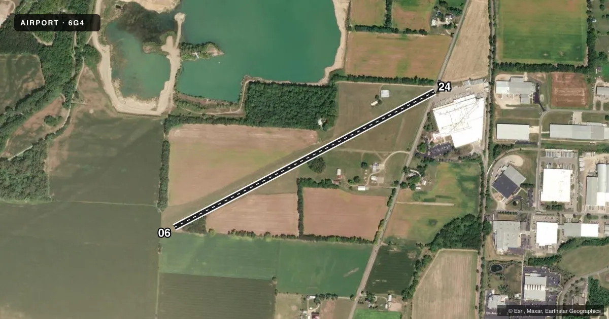
Runways & pattern
Full pagePattern entry · RWY 06
LEFT TRAFFICRunway end performance
| End | TORA | TODA | ASDA | LDA | VGSI | Approach lights | Obstruction |
|---|---|---|---|---|---|---|---|
| 06 | — | — | — | — | — | — | 12', crops, 48' from thr, 45' R of cntrln, slope 4 |
| 24 | — | — | — | — | — | — | 16', road, 0' from thr, 80' R of cntrln, slope 0 |
Declared distances in feet. TORA = takeoff run available, TODA = takeoff distance, ASDA = accelerate-stop, LDA = landing distance.
Airport sketch
Runways drawn to scale from FAA survey coordinates, rendered over satellite imagery. Not for navigation.
Approaches & charts
Services on the field
Fuel grades, oxygen, maintenance, ramp storage and lighting — as declared to the FAA by the airport operator.
Fuel & services
- Fuel
- Not available
- Oxygen (bottled)
- Not available
- Oxygen (bulk)
- Not available
- Airframe repair
- Not available
- Power plant repair
- Not available
Ramp & ground
- Transient storage
- Tie-down
- Hangar
- Landing fee
- No fee published
- Customs
- Not available
- Lighting schedule
- SEE RMK
- Beacon schedule
- SEE RMK
- Beacon
- White / Green (civil land)(WG)
- Wind indicator
- Yes
- Segmented circle
- No
Fuel & FBOs
Cheapest 100LL and Jet A on the field and nearby. Always confirm with the FBO before taxi.
Airport notes
Surface conditions, obstructions, local procedures, lighting outages and other notes published with each FAA cycle.
General notes
- -1 FT DITCH RWY 24 END 0 FT FM LEFT & RIGHT.
- DEER ON & INVOF ARPT.
- FOR CD CTC COLUMBUS APCH AT 614-338-8537.
- CALL AMGR FOR FLD CONDS NOV-APR.
Lighting notes
- ACTVT ABN - CALL AMGR.
- ACTVT NSTD LIRL - CALL AMGR.
Runway surface & condition
- 06/24NSTD LIRL DUE TO NO THR LGTS.
Approach & departure obstructions
- 06ORANGE CONES APRXLY 3000 FT.
- 24ORANGE CONES APRXLY 3000 FT.
- 0660 FT TREE, 210 FT DIST, 45 FT R, 3:1.
Other notes
- ESTABD BFR 1959.
- PRIOR CDN RQRD.
- ROPES & ANCHORS NOT PRVDD.
VFR map & nearby airports
VFR sectional. Tap any ICAO chip to open that airport.
Key facts · 6G4
Answer card- ICAO
- 6G4
- Name
- WYNKOOP
- Location
- MOUNT VERNON, OHIO
- Elevation
- 1,041 ft MSL
- Traffic pattern altitude
- 2,041 ft MSL (1,000 AGL)
- Control tower
- Non-towered (use CTAF)
- Total runways
- 1
- Longest runway
- 06/24 · 3,460 ft
- Published ILS approaches
- 0
- Published frequencies
- 1
- Magnetic variation
- –
- Current flight rules
- MVFR
- Current wind
- 000° at 0 kt
- Favored runway now
- –
Wynkoop (6G4) sits in Mount Vernon, Ohio. Field elevation is 1,041 ft MSL. The airport has one runway. Runway 06/24 is 3,460 ft of turf, which is the longest runway on the field. There is no control tower. CTAF is 122.9.
No ILS approaches are published here. Pattern altitude is not published, so use the standard 1,000 ft AGL for light piston operations unless the current FAA Chart Supplement says otherwise. The published remarks matter here. Runway lighting is nonstandard low-intensity lighting because there are no threshold lights. The lights are activated by calling the airport manager. The airport beacon is also activated by request. Deer are reported on and near the airport. There is also a 1-foot ditch at the Runway 24 end, right at the edges. A 60-foot tree sits near the Runway 06 end. Orange cones are reported about 3,000 feet from each runway end.
No on-field FBOs are listed. Check with the airport operator or the FBO directly by phone before arrival for current services. Clearance delivery is handled through Columbus Approach at 614-338-8537. For a first-time arrival, plan for a turf surface, nonstandard lighting and wildlife on the field. Call the airport manager for field conditions from November through April.