METAR & TAF 4I9
4I9 does not publish a METAR.
Showing the nearest reporting station: KMNN (MARION MUNI) · 11.2 NM away. Conditions at 4I9 may differ.
METAR · KMNN
Observed 14:53Z
KMNN 271453Z AUTO 25006KT 9SM CLR 24/21 A2993 RMK AO2 SLP130 T02440211 58005
- Wind
- 250° @ 6 kt
- Visibility
- 9 SM
- Temp / Dew
- 24°C / 21°C
- Altimeter
- 29.93 inHg
- Clouds
- CLR
- Density alt
- 2,414 ft
- Ceiling
- Unlimited
- Rules
- VFR
Airport info & contacts
Manager on record, flight service, ARTCC, attendance schedule and pattern altitude — published by the FAA and refreshed every 28 days.
Location
- From city
- 2 NM SW
- VFR sectional
- DETROIT
- ARTCC
- ZID · INDIANAPOLIS
- NOTAM facility
- 4I9 (NOTAM-D)
Airport manager
- Name
- CARL FISHER JR
- Phone
- 419-947-1833
- Address
- 4679 TOWNSHIP ROAD 126, CARDINGTON OH 43315-9511
Flight service · Hours
- FSS CLE
- CLEVELAND1-800-WX-BRIEF
- Attendance
- MON-FRI · 0900-1800
Frequencies
Tap any row to copy the frequency to your clipboard.
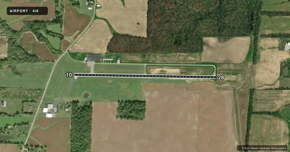
Runways & pattern
Full pagePattern entry · RWY 28
LEFT TRAFFICRunway end performance
| End | TORA | TODA | ASDA | LDA | VGSI | Approach lights | Obstruction |
|---|---|---|---|---|---|---|---|
| 10 | — | — | — | — | — | — | 60', trees, 930' from thr, 295' R of cntrln, slope 12 |
| 28 | — | — | — | — | PAPI 4-box left(4°) | — | 75', trees, 930' from thr, 285' R of cntrln, slope 9 |
Declared distances in feet. TORA = takeoff run available, TODA = takeoff distance, ASDA = accelerate-stop, LDA = landing distance.
Airport sketch
Runways drawn to scale from FAA survey coordinates, rendered over satellite imagery. Not for navigation.
Approaches & charts
Services on the field
Fuel grades, oxygen, maintenance, ramp storage and lighting — as declared to the FAA by the airport operator.
Fuel & services
- Fuel
- 100LLMOGAS
- Oxygen (bottled)
- Not available
- Oxygen (bulk)
- Not available
- Airframe repair
- Major
- Power plant repair
- Major
- Other services
- AGRI
Ramp & ground
- Transient storage
- Tie-down
- Hangar
- Landing fee
- No fee published
- Customs
- Not available
- Lighting schedule
- SEE RMK
- Beacon schedule
- SS-SR
- Beacon
- White / Green (civil land)(WG)
- Wind indicator
- Yes
- Segmented circle
- No
Fuel & FBOs
Cheapest 100LL and Jet A on the field and nearby. Always confirm with the FBO before taxi.
Airport notes
Surface conditions, obstructions, local procedures, lighting outages and other notes published with each FAA cycle.
General notes
- FOR CD CTC COLUMBUS APCH AT 614-338-8537.
Lighting notes
- ACTVT PAPI RWY 28; MIRL RWY 10/28 - CTAF.
Approach & departure obstructions
- 28+2 FT CROPS, 30-200 FT DIST, 175 FT L TO 250 FT R.
Other notes
- VFR OPS ONLY.
- PRIOR CDN RQRD FOR LTD TSNT HNGR.
- PRIOR CDN RQRD FOR ROPES.
- 1FOR SVC AFT HRS CALL AMGR.
- MANAGEROFC.
- OWNERCOUNTY ECONOMIC DEVELOPMENT OFC.
VFR map & nearby airports
VFR sectional. Tap any ICAO chip to open that airport.
Key facts · 4I9
Answer card- ICAO
- 4I9
- Name
- MORROW COUNTY
- Location
- MOUNT GILEAD, OHIO
- Elevation
- 1,085.8 ft MSL
- Traffic pattern altitude
- 2,085.8 ft MSL (1,000 AGL)
- Control tower
- Non-towered (use CTAF)
- Total runways
- 1
- Longest runway
- 10/28 · 3,495 ft
- Published ILS approaches
- 0
- Published frequencies
- 5
- Magnetic variation
- 8°
- Current flight rules
- VFR
- Current wind
- 250° at 6 kt
- Favored runway now
- RWY 28
Morrow County Airport sits in Mount Gilead, Ohio. Field elevation is 1,085.8 ft MSL. It has one runway, 10/28, which is 3,495 ft long and paved. This is a non-towered field. CTAF and UNICOM are both 122.8. Published approach support comes from Columbus, with no ILS approaches published at the airport.
Pattern altitude is not published. Use 2,086 ft MSL for light piston traffic if you are working the standard 1,000 ft AGL pattern. The airport is VFR operations only. That matters here. Plan to stay ahead of the airplane and keep your arrival simple.
Runway lighting is medium intensity on 10/28 and is controlled by CTAF. PAPI is active on runway 28. Published remarks also note crops near runway 10, close enough to matter on the takeoff and landing roll. If you need clearance delivery, contact Columbus Approach at 614-338-8537. For service after hours, call the airport manager. There are no on-field FBOs listed, so verify current fuel and service options with the airport operator or the FBO directly by phone before you go.