METAR & TAF KDLZ
Current METAR
Observed 13:35Z
KDLZ 271335Z AUTO VRB04KT 10SM CLR 23/23 A2993 RMK AO2
- Wind
- VAR @ 4 kt
- Visibility
- 10 SM
- Temp / Dew
- 23°C / 23°C
- Altimeter
- 29.93 inHg
- Clouds
- CLR
- Density alt
- 2,120 ft
- Ceiling
- Unlimited
- Rules
- VFR
Airport info & contacts
Manager on record, flight service, ARTCC, attendance schedule and pattern altitude — published by the FAA and refreshed every 28 days.
Location
- From city
- 3 NM SW
- VFR sectional
- DETROIT
- ARTCC
- ZID · INDIANAPOLIS
- NOTAM facility
- DLZ (NOTAM-D)
Airport manager
- Name
- KEVIN PIATT
- Phone
- 740-203-1870
- Address
- 1075 PITTSBURGH DR, DELAWARE OH 43015-3848
Flight service · Hours
- FSS DAY
- DAYTON1-800-WX-BRIEF
- Attendance
- 0800-1700
Frequencies
Tap any row to copy the frequency to your clipboard.
Runways & pattern
Full pagePattern entry · RWY 28
LEFT TRAFFICRunway end performance
| End | TORA | TODA | ASDA | LDA | VGSI | Approach lights | Obstruction |
|---|---|---|---|---|---|---|---|
| 10 | — | — | — | — | PAPI 4-box left(3°) | — | 144', hill, 3061' from thr, 314' R of cntrln, slope 19 |
| 28 | — | — | — | — | PAPI 4-box left(3°) | — | 75', trees, 1476' from thr, 230' R of cntrln, slope 17 |
Declared distances in feet. TORA = takeoff run available, TODA = takeoff distance, ASDA = accelerate-stop, LDA = landing distance.
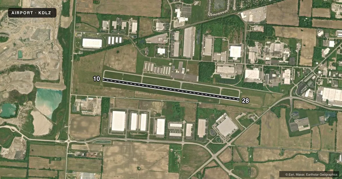
Airport sketch
Runways drawn to scale from FAA survey coordinates, rendered over satellite imagery. Not for navigation.
Approaches & charts
Services on the field
Fuel grades, oxygen, maintenance, ramp storage and lighting — as declared to the FAA by the airport operator.
Fuel & services
- Fuel
- 100LLAA+
- Oxygen (bottled)
- Low pressure
- Oxygen (bulk)
- Not available
- Airframe repair
- Major
- Power plant repair
- Major
- Other services
- INSTR,RNTL
Ramp & ground
- Transient storage
- Tie-down
- Hangar
- Landing fee
- No fee published
- Customs
- Not available
- Lighting schedule
- SEE RMK
- Beacon schedule
- SS-SR
- Beacon
- White / Green (civil land)(WG)
- Wind indicator
- Lighted
- Segmented circle
- No
Fuel & FBOs
Cheapest 100LL and Jet A on the field and nearby. Always confirm with the FBO before taxi.
Airport notes
Surface conditions, obstructions, local procedures, lighting outages and other notes published with each FAA cycle.
General notes
- OCNL DEER & OTR WILDLIFE ON & INVOF ARPT.
- INTMT NGT ACT AT QUARRY OFF WEST END OF RWY 10.
- ULTRALIGHT TFC RMN S OF RWY AT 400 FT AGL.
- FOR CD CTC COLUMBUS APCH AT 614-338-8537.
Lighting notes
- ACTVT REIL RWY 10 & 28; PAPI RWY 10 & 28; MIRL RWY 10/28 - CTAF.
Approach & departure obstructions
- 28CALM WIND RWY.
- 28PAPI UNUSBL BYD 8 DEGS RIGHT OF CNTRLN.
Other notes
- VFR ONLY.
- PRIOR CDN RQRD.
- 2CLSD THANKSGIVING, CHRISTMAS, & NEW YEARS.
- MANAGERAFT HRS 740-203-1870, OPTION 9.
VFR map & nearby airports
VFR sectional. Tap any ICAO chip to open that airport.
Key facts · KDLZ
Answer card- ICAO
- KDLZ
- Name
- DELAWARE MUNI/JIM MOORE FLD
- Location
- DELAWARE, OHIO
- Elevation
- 945.1 ft MSL
- Traffic pattern altitude
- 1,945.1 ft MSL (1,000 AGL)
- Control tower
- Non-towered (use CTAF)
- Total runways
- 1
- Longest runway
- 10/28 · 5,800 ft
- Published ILS approaches
- 0
- Published frequencies
- 4
- Magnetic variation
- 6°
- Current flight rules
- VFR
- Current wind
- 000° at 4 kt
- Favored runway now
- RWY 28
DELAWARE MUNI/JIM MOORE FLD is in Delaware, Ohio. The field elevation is 945.1 ft MSL. It has one runway, 10/28, which is 5,800 ft long and asphalt. There is no control tower. The airport is VFR only. No ILS approaches are published.
Pattern altitude is not published. Use 1,000 ft AGL for light piston traffic unless the current FAA Chart Supplement says otherwise. Runway 10/28 has REILs and PAPI. Medium intensity runway lights are on runway 10/28 and are controlled by CTAF. Runway 28 is the calm wind runway. The PAPI on runway 28 is unusable beyond 8 degrees right of centerline.
Delaware Municipal Airport is the on-field FBO. It carries 100LL, Jet A and Jet A Prist. Call (740) 203-1870 for current service details. Prior coordination is required. After hours, use option 9 on that number. Watch for deer and other wildlife near the airport. Ultralight traffic stays south of the runway at 400 ft AGL. There is also intermittent night activity from the quarry off the west end of runway 10. For clearance delivery, contact Columbus Approach. This is a non-towered field with published approach control frequencies. Keep your radio work tight. Verify current procedures before you go.