METAR & TAF KMNN
Current METAR
Observed 08:53Z
KMNN 270853Z AUTO 00000KT 5SM BR CLR 17/17 A2990 RMK AO2 SLP120 T01720172 56003
- Wind
- 000° @ 0 kt
- Visibility
- 5 SM
- Temp / Dew
- 17°C / 17°C
- Altimeter
- 29.90 inHg
- Clouds
- CLR
- Density alt
- 1,497 ft
- Ceiling
- Unlimited
- Rules
- MVFR
Airport info & contacts
Manager on record, flight service, ARTCC, attendance schedule and pattern altitude — published by the FAA and refreshed every 28 days.
Location
- From city
- 3 NM NE
- VFR sectional
- DETROIT
- Pattern altitude
- 800 ft AGL · 1,793 ft MSL
- ARTCC
- ZOB · CLEVELAND
- NOTAM facility
- MNN (NOTAM-D)
Airport manager
- Name
- MATTHEW "MATT" ARNOLD
- Phone
- 740-382-1634
- Address
- 1530 POLE LANE RD, MARION OH 43302-8514
Flight service · Hours
- FSS CLE
- CLEVELAND1-800-WX-BRIEF
- Attendance
- 0800-1700
Frequencies
Tap any row to copy the frequency to your clipboard.
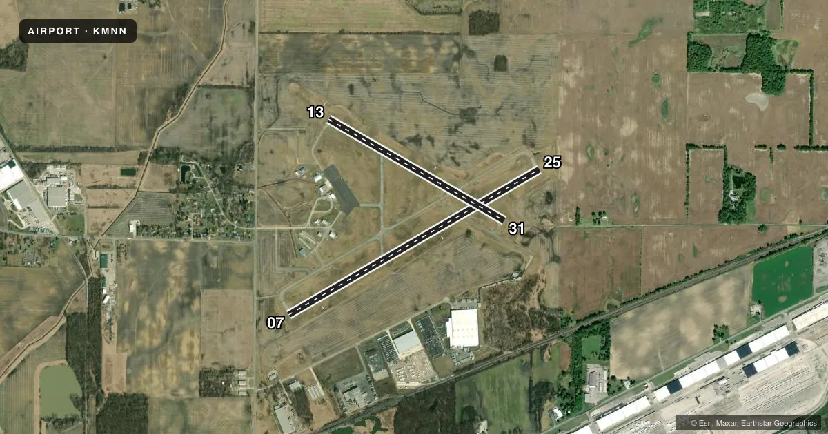
Runways & pattern
Full pagePattern entry · RWY 07
LEFT TRAFFIC| Runway | Heading (°M) | Length | Surface | Traffic |
|---|---|---|---|---|
| 07/25 | 55° / 235° | 5,000 ft | ASPH | Standard L |
| 13/31 | 115° / 295° | 3,498 ft | ASPH | Standard L |
Runway end performance
| End | TORA | TODA | ASDA | LDA | VGSI | Approach lights | Obstruction |
|---|---|---|---|---|---|---|---|
| 07 | — | — | — | — | PAPI 4-box left(3°) | — | 15', road, 475' from thr, 280' R of cntrln, slope 18 |
| 25 | — | — | — | — | PAPI 4-box left(3°) | — | — |
| 13 | — | — | — | — | PAPI 2-box right(3°) | — | 3', crops, 201' from thr, 50' R of cntrln, slope 0 |
| 31 | — | — | — | — | PAPI 2-box left(3°) | — | — |
Declared distances in feet. TORA = takeoff run available, TODA = takeoff distance, ASDA = accelerate-stop, LDA = landing distance.
Airport sketch
Runways drawn to scale from FAA survey coordinates, rendered over satellite imagery. Not for navigation.
Approaches & charts
Services on the field
Fuel grades, oxygen, maintenance, ramp storage and lighting — as declared to the FAA by the airport operator.
Fuel & services
- Fuel
- 100LLA1
- Oxygen (bottled)
- Not available
- Oxygen (bulk)
- Not available
- Airframe repair
- Major
- Power plant repair
- Major
- Other services
- AFRT,AGRI,CHTR,GLD,INSTR,RNTL,SALES,TOW
Ramp & ground
- Transient storage
- Tie-down
- Hangar
- Landing fee
- No fee published
- Customs
- Not available
- Lighting schedule
- SEE RMK
- Beacon schedule
- SS-SR
- Beacon
- White / Green (civil land)(WG)
- Wind indicator
- Lighted
- Segmented circle
- No
Fuel & FBOs
Cheapest 100LL and Jet A on the field and nearby. Always confirm with the FBO before taxi.
Airport notes
Surface conditions, obstructions, local procedures, lighting outages and other notes published with each FAA cycle.
General notes
- GLIDER ACT ON & INVOF ARPT, ANNC INTNS - CTAF.
- TSNT ACFT FOLLOW RAMP SIGNS TO MAIN RAMP. TWY D BTN RWY & RAMP AREA RSTRD TO ACFT WITH WINGSPAN 35 FT OR LESS.
- FOR CD CTC CLEVELAND APCH AT 216-352-2323, WHEN APCH CLSD CTC CLEVELAND ARTCC AT 440-774-0222.
- OCNL DEER, BIRDS, & OTR WILDLIFE ON & INVOF ARPT.
Lighting notes
- ACTVT REIL RWY 07, 25, 13, & 31; MIRL RWY 07/25 & 13/31 - CTAF. PAPI RWY 07, 25, 13, & 31 OPR CONSLY.
Fuel notes
- 100LL100LL AVBL H24 SELF SER VIA CREDIT CARD. JET A AVBL AFT HRS BY PRIOR CDN.
Approach & departure obstructions
- 13+3 FT CROPS 200 FT FM EXTEND TO THLD 55 FT R & 245 FT L.
- 07GLIDERS & TOWPLANES USE RIGHT TFC.
- 31GLIDERS & TOWPLANES USE RIGHT TFC.
- 13+3 FT CROPS 201 FT FM 55 FT R & 245 FT L.
Other notes
- ESTABD BFR 1959.
- TNST HGR: PPR.
- MANAGERARPT OPS MGR 740-725-4146. ARPT DIR FOR EMERG ONLY 740-341-2233.
VFR map & nearby airports
VFR sectional. Tap any ICAO chip to open that airport.
Key facts · KMNN
Answer card- ICAO
- KMNN
- Name
- MARION MUNI
- Location
- MARION, OHIO
- Elevation
- 993.4 ft MSL
- Traffic pattern altitude
- 1,793.4 ft MSL (800 AGL)
- Control tower
- Non-towered (use CTAF)
- Total runways
- 2
- Longest runway
- 07/25 · 5,000 ft
- Published ILS approaches
- 0
- Published frequencies
- 5
- Magnetic variation
- 5°
- Current flight rules
- MVFR
- Current wind
- 000° at 0 kt
- Favored runway now
- –
Marion Muni is in Marion, Ohio. The field elevation is 993.4 ft MSL. It has two asphalt runways. The longest is 5,000 ft on 07/25. There is no control tower. Pattern altitude is 800 ft AGL, which is 1,793.4 ft MSL.
No ILS approaches are published here. Cleveland Approach handles clearance delivery and approach services when open. CTAF and UNICOM are both 122.8. Published remarks note 24-hour self-serve 100LL by credit card. Jet A is available after hours with prior coordination. That is useful if you are planning a late arrival or an early departure.
The airport has glider activity on and near the field. Make your intentions clear on CTAF. Runway 07 uses right traffic for gliders and towplanes. Taxiway D between the runway and ramp area is restricted to aircraft with a wingspan of 35 feet or less. Transient aircraft should follow the ramp signs to the main ramp. There are also crops near the extended runway 13 threshold. Expect to stay alert for deer, birds and other wildlife. The airport is a bit above 990 ft MSL. That is not high mountain terrain. It still deserves normal density altitude planning on warm days.