METAR & TAF 12G
12G does not publish a METAR.
Showing the nearest reporting station: KMFD (MANSFIELD LAHM RGNL) · 8.8 NM away. Conditions at 12G may differ.
METAR · KMFD
Observed 16:52Z
KMFD 251652Z 30005KT 10SM CLR 24/13 A3008 RMK AO2 SLP180 T02390133 $
- Wind
- 300° @ 5 kt
- Visibility
- 10 SM
- Temp / Dew
- 24°C / 13°C
- Altimeter
- 30.08 inHg
- Clouds
- CLR
- Density alt
- 2,271 ft
- Ceiling
- Unlimited
- Rules
- VFR
Airport info & contacts
Manager on record, flight service, ARTCC, attendance schedule and pattern altitude — published by the FAA and refreshed every 28 days.
Location
- From city
- 2 NM WSW
- VFR sectional
- DETROIT
- ARTCC
- ZOB · CLEVELAND
- NOTAM facility
- CLE (NOTAM-D)
Airport manager
- Name
- DOUG SCHMIDT
- Phone
- 419-347-1185
- Address
- 5085 STATE ROUTE 39 W, SHELBY OH 44875-9061
Flight service · Hours
- FSS CLE
- CLEVELAND1-800-WX-BRIEF
- Attendance
- 0600-1700
Frequencies
Tap any row to copy the frequency to your clipboard.
Runways & pattern
Full pagePattern entry · RWY 36
LEFT TRAFFIC| Runway | Heading (°M) | Length | Surface | Traffic |
|---|---|---|---|---|
| 18/36Favored | 173° / 353° | 3,174 ft | ASPH | Standard L |
| 03/21 | 19° / 199° | 1,890 ft | TURF | Standard L |
Runway end performance
| End | TORA | TODA | ASDA | LDA | VGSI | Approach lights | Obstruction |
|---|---|---|---|---|---|---|---|
| 18 | — | — | — | — | — | — | 15', road, 201' from thr, 10' R of cntrln, slope 0 |
| 36 | — | — | — | — | — | — | 8', crops, 201' from thr, 75' R of cntrln, slope 0 |
| 03 | — | — | — | — | — | — | 8', crops, 0' from thr, 65' R of cntrln, slope 0 |
| 21 | — | — | — | — | — | — | 15', road, 240' from thr, 140' R of cntrln, slope 16 |
Declared distances in feet. TORA = takeoff run available, TODA = takeoff distance, ASDA = accelerate-stop, LDA = landing distance.
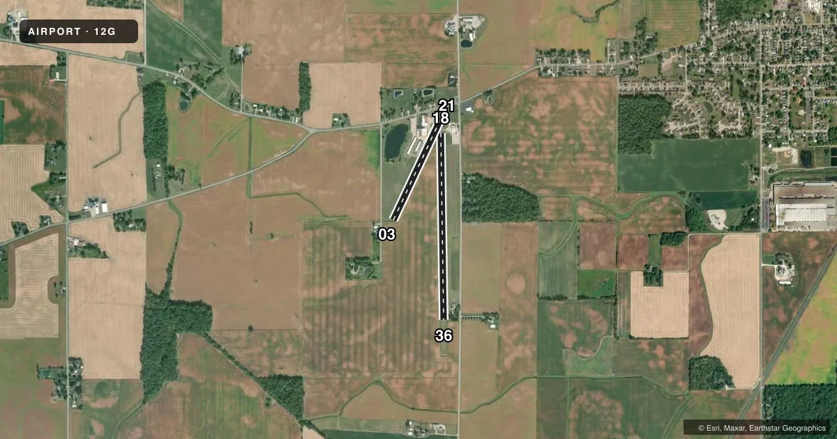
Airport sketch
Runways drawn to scale from FAA survey coordinates, rendered over satellite imagery. Not for navigation.
Approaches & charts
Services on the field
Fuel grades, oxygen, maintenance, ramp storage and lighting — as declared to the FAA by the airport operator.
Fuel & services
- Fuel
- Not available
Ramp & ground
- Transient storage
- Tie-down
- Hangar
- Landing fee
- No fee published
- Customs
- Not available
- Lighting schedule
- SS-SR
- Beacon schedule
- SS-SR
- Beacon
- White / Green (civil land)(WG)
- Wind indicator
- Lighted
- Segmented circle
- No
Fuel & FBOs
Cheapest 100LL and Jet A on the field and nearby. Always confirm with the FBO before taxi.
Airport notes
Surface conditions, obstructions, local procedures, lighting outages and other notes published with each FAA cycle.
General notes
- FOR CD CTC CLEVELAND APCH AT 216-352-2323, WHEN APCH CLSD CTC CLEVELAND ARTCC AT 440-774-0223/0490.
Runway surface & condition
- 18/36NSTD LIRL DUE TO RWY 18 THR LGTS 220 FT FM RWY END; RWY LGTS 62 FT FM EAST EDGE & 47 FT FM WEST EDGE.
Approach & departure obstructions
- 18ROAD, 165 FT DIST, 125 FT R.
- 360-8 FT SEASONAL CROPS, 75 FT L/R.
- 36CALM WIND RWY.
- 18FADED.
- 36FADED.
- 03+8 FT CROPS, 0 FT DIST, 65 FT R, 0:1 OBSTN CLNC SLP.
- 18+15 FT ROAD, 201 FT DIST, 10 FT L, 0:1 OBSTN CLNC SLP.
- 36+8 FT CROPS, 0 FT DIST, 75 FT R, 0:1 OBSTN CLNC SLP.
Other notes
- THIS AIRPORT HAS BEEN SURVEYED BY THE NATIONAL GEODETIC SURVEY.
- ESTABD BFR 1959.
- PRIOR CDN RQRD FOR TSNT HNGR.
- ROPES NOT PRVDD FOR TSNT TIEDOWN.
- OWNERMAILING ADS.
- MANAGERINFO@SHELBYAIRPORT.COM.
- MANAGEROR 419-347-8543.
- 18/36NMRS UNSEALED CRACKS & DTRTD PAVEMENT, HIGH FOD POTENTIAL.
VFR map & nearby airports
VFR sectional. Tap any ICAO chip to open that airport.
Key facts · 12G
Answer card- ICAO
- 12G
- Name
- SHELBY COMMUNITY
- Location
- SHELBY, OHIO
- Elevation
- 1,120.4 ft MSL
- Traffic pattern altitude
- 2,120.4 ft MSL (1,000 AGL)
- Control tower
- Non-towered (use CTAF)
- Total runways
- 2
- Longest runway
- 18/36 · 3,174 ft
- Published ILS approaches
- 0
- Published frequencies
- 4
- Magnetic variation
- 6°
- Current flight rules
- VFR
- Current wind
- 300° at 5 kt
- Favored runway now
- RWY 36
Shelby Community Airport sits in Shelby, Ohio. Field elevation is 1,120.4 ft MSL. The airport has 2 runways. The longest is runway 18/36 at 3,174 ft, with a turf crosswind runway 03/21 at 1,890 ft. The field is non-towered. CTAF and UNICOM are both 122.8. Cleveland approach and departure are on 128.35 and 360.65.
No ILS approaches are published here. Pattern altitude is not published, so use the standard 1,000 ft AGL for light piston operations unless the current Chart Supplement says otherwise. The published remarks matter here. Runway 36 has faded markings. Runway 18 also has faded markings. Runway 36 is listed as the calm wind runway. There are seasonal crops near runway 36. There is also a road near the runway 18 end, with an additional road obstruction close to the departure end.
This is a small field with a few things to watch on arrival. The runway 18/36 lighting is nonstandard low intensity. Transient tiedown ropes are not provided. No on-field FBOs are listed, so confirm fuel and services with the airport operator or the FBO directly by phone before you go. The airport manager can be reached at 419-347-8543. For any noise, curfew, or other local operating limits, check the current FAA Chart Supplement before flying in.