METAR & TAF 3G4
3G4 does not publish a METAR.
Showing the nearest reporting station: KMFD (MANSFIELD LAHM RGNL) · 12.8 NM away. Conditions at 3G4 may differ.
METAR · KMFD
Observed 19:52Z
KMFD 271952Z 23008KT 10SM CLR 28/19 A2986 RMK AO2 SLP100 T02830194 $
- Wind
- 230° @ 8 kt
- Visibility
- 10 SM
- Temp / Dew
- 28°C / 19°C
- Altimeter
- 29.86 inHg
- Clouds
- CLR
- Density alt
- 3,131 ft
- Ceiling
- Unlimited
- Rules
- VFR
Airport info & contacts
Manager on record, flight service, ARTCC, attendance schedule and pattern altitude — published by the FAA and refreshed every 28 days.
Location
- From city
- 3 NM NE
- VFR sectional
- DETROIT
- ARTCC
- ZOB · CLEVELAND
- NOTAM facility
- CLE (NOTAM-D)
Airport manager
- Name
- DENNIS BAUM
- Phone
- 419-281-3966
- Address
- 700 TOWNSHIP ROAD 1102, ASHLAND OH 44805-8935
Flight service · Hours
- FSS CLE
- CLEVELAND1-800-WX-BRIEF
- Attendance
- 0800-1800
Frequencies
Tap any row to copy the frequency to your clipboard.
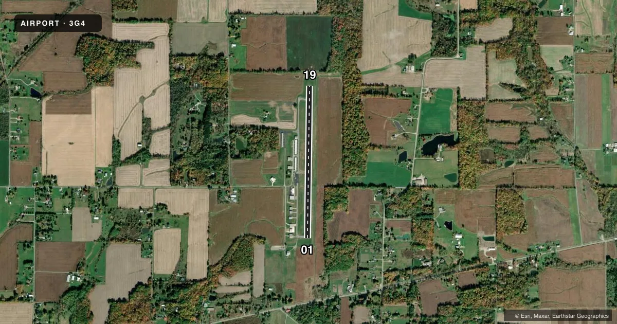
Runways & pattern
Full pagePattern entry · RWY 19
LEFT TRAFFICRunway end performance
| End | TORA | TODA | ASDA | LDA | VGSI | Approach lights | Obstruction |
|---|---|---|---|---|---|---|---|
| 01 | — | — | — | — | PAPI 4-box left(3°) | — | 87', trees, 1661' from thr, 181' R of cntrln, slope 16 |
| 19 | — | — | — | — | VASI 2-box left(3°) | — | 69', trees, 285' from thr, 239' R of cntrln, slope 1 |
Declared distances in feet. TORA = takeoff run available, TODA = takeoff distance, ASDA = accelerate-stop, LDA = landing distance.
Airport sketch
Runways drawn to scale from FAA survey coordinates, rendered over satellite imagery. Not for navigation.
Approaches & charts
Services on the field
Fuel grades, oxygen, maintenance, ramp storage and lighting — as declared to the FAA by the airport operator.
Fuel & services
- Fuel
- 100LLA+
- Airframe repair
- Minor
- Power plant repair
- Minor
- Other services
- INSTR,PAJA,RNTL
Ramp & ground
- Transient storage
- Tie-down
- Hangar
- Landing fee
- No fee published
- Customs
- Not available
- Lighting schedule
- SEE RMK
- Beacon schedule
- SS-SR
- Beacon
- White / Green (civil land)(WG)
- Wind indicator
- Lighted
- Segmented circle
- No
Fuel & FBOs
Cheapest 100LL and Jet A on the field and nearby. Always confirm with the FBO before taxi.
Airport notes
Surface conditions, obstructions, local procedures, lighting outages and other notes published with each FAA cycle.
General notes
- OCNL DEER ON & INVOF ARPT.
- FOR CD CTC CLEVELAND APCH AT 216-352-2323, WHEN APCH CLSD CTC CLEVELAND ARTCC AT 440-774-0223/0490.
- EXTSV PAJA; LDG ZONE LCTD AT SW CORNER OF ARPT PROPERTY.
Lighting notes
- ACTVT REIL RWY 01 & 19; PAPI RWY 01; VASI RWY 19; MIRL RWY 01/19 - CTAF.
Fuel notes
- 100LL100LL & JET A AVBL AFT HRS - CALL AMGR CELL.
Other notes
- MANAGERCELL 419-685-1875.
VFR map & nearby airports
VFR sectional. Tap any ICAO chip to open that airport.
Key facts · 3G4
Answer card- ICAO
- 3G4
- Name
- ASHLAND COUNTY
- Location
- ASHLAND, OHIO
- Elevation
- 1,206.7 ft MSL
- Traffic pattern altitude
- 2,206.7 ft MSL (1,000 AGL)
- Control tower
- Non-towered (use CTAF)
- Total runways
- 1
- Longest runway
- 01/19 · 3,501 ft
- Published ILS approaches
- 0
- Published frequencies
- 4
- Magnetic variation
- 7°
- Current flight rules
- VFR
- Current wind
- 230° at 8 kt
- Favored runway now
- RWY 19
Ashland County Airport (3G4) sits in Ashland, Ohio. Field elevation is 1,206.7 ft MSL. The airport has one runway. Runway 01/19 is 3,501 ft long and asphalt. There is no control tower. No ILS approaches are published here.
Pattern altitude is not published. Use 1,000 ft AGL for light piston operations unless the current Chart Supplement says otherwise. The field uses CTAF 122.7. Cleveland Approach handles the area on 128.35 and 360.65. Clearance delivery is handled by Cleveland Approach when available. When approach is closed, contact Cleveland ARTCC using the published phone numbers.
Tailwinds Aviation is on the field. It carries 100LL and Jet A. After-hours fuel is available by calling the airport manager. Runway end identifier lights are on 01 and 19. Runway 01 has PAPI. Runway 19 has VASI. Medium intensity runway lights are on both ends. Lighting is controlled on CTAF. Expect occasional deer on and near the airport. There is also extensive pajama grass. The landing zone is at the southwest corner of the airport property. If you are new to the field, brief the runway lighting and the wildlife picture before arrival.