METAR & TAF KBJJ
Current METAR
Observed 17:56Z
KBJJ 271756Z AUTO 25008KT 10SM FEW037 27/21 A2987 RMK AO2 SLP106 T02720206 10278 20206 58021
- Wind
- 250° @ 8 kt
- Visibility
- 10 SM
- Temp / Dew
- 27°C / 21°C
- Altimeter
- 29.87 inHg
- Clouds
- FEW
- Density alt
- 2,910 ft
- Ceiling
- Unlimited
- Rules
- VFR
Airport info & contacts
Manager on record, flight service, ARTCC, attendance schedule and pattern altitude — published by the FAA and refreshed every 28 days.
Location
- From city
- 6 NM NE
- VFR sectional
- DETROIT
- ARTCC
- ZOB · CLEVELAND
- NOTAM facility
- BJJ (NOTAM-D)
Airport manager
- Name
- MATTHEW LONG
- Phone
- 330-669-9212
- Address
- 6020 N HONEYTOWN RD, SMITHVILLE OH 44677-9563
Flight service · Hours
- FSS CLE
- CLEVELAND1-800-WX-BRIEF
- Attendance
- 0700-1800
Frequencies
Tap any row to copy the frequency to your clipboard.
Runways & pattern
Full pagePattern entry · RWY 28
LEFT TRAFFICRunway end performance
| End | TORA | TODA | ASDA | LDA | VGSI | Approach lights | Obstruction |
|---|---|---|---|---|---|---|---|
| 10 | — | — | — | — | PAPI 4-box left(3.04°) | — | — |
| 28 | — | — | — | — | VASI 4-box right(3°) | — | 5', road, 201' from thr, 0' R of cntrln, slope 1 |
Declared distances in feet. TORA = takeoff run available, TODA = takeoff distance, ASDA = accelerate-stop, LDA = landing distance.
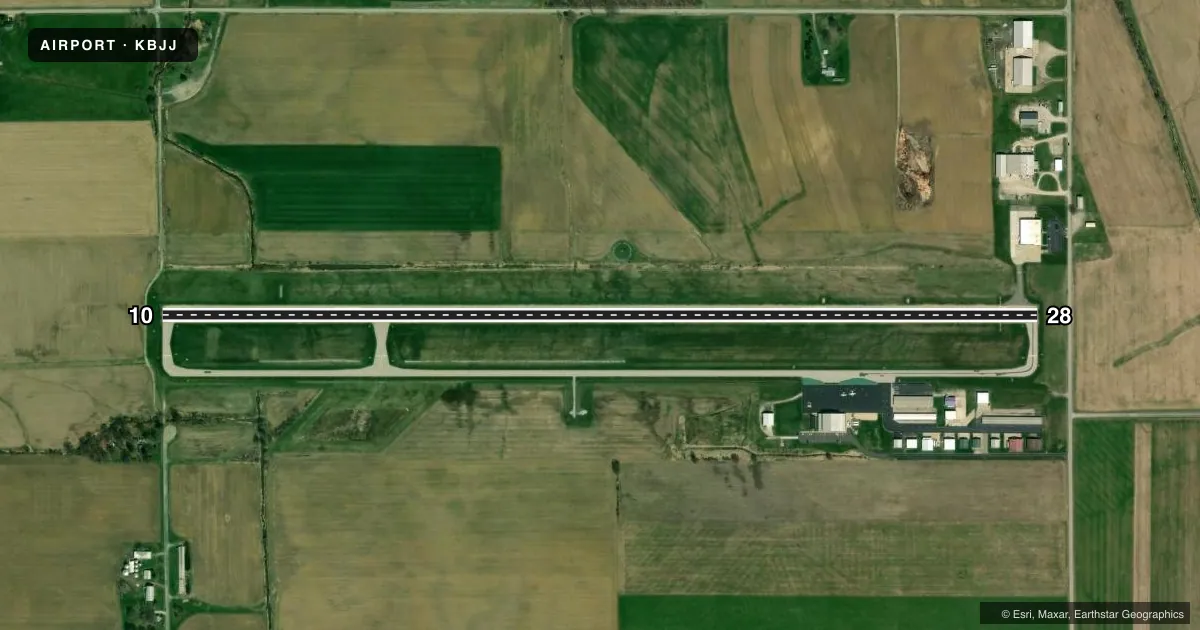
Airport sketch
Runways drawn to scale from FAA survey coordinates, rendered over satellite imagery. Not for navigation.
Approaches & charts
Services on the field
Fuel grades, oxygen, maintenance, ramp storage and lighting — as declared to the FAA by the airport operator.
Fuel & services
- Fuel
- 100LLAA1+
- Oxygen (bottled)
- Not available
- Oxygen (bulk)
- High pressure
- Airframe repair
- Major
- Power plant repair
- Major
- Other services
- AMB,INSTR,RNTL
Ramp & ground
- Transient storage
- Tie-down
- Hangar
- Landing fee
- No fee published
- Customs
- Not available
- Lighting schedule
- SEE RMK
- Beacon schedule
- SS-SR
- Beacon
- White / Green (civil land)(WG)
- Wind indicator
- Lighted
- Segmented circle
- Yes
Fuel & FBOs
Cheapest 100LL and Jet A on the field and nearby. Always confirm with the FBO before taxi.
Airport notes
Surface conditions, obstructions, local procedures, lighting outages and other notes published with each FAA cycle.
General notes
- DEER ON & INVOF ARPT.
- FOR CD CTC CLEVELAND APCH AT 216-352-2323, WHEN APCH CLSD CTC CLEVELAND ARTCC AT 440-774-0223/0490.
Lighting notes
- ACTVT OR INCR INTST REIL RWY 10 & 28; PAPI RWY 10; VASI RWY 28; HIRL RWY 10/28 - CTAF. HIRL RWY 10/28 PRESET LOW INTST DUSK-DAWN.
Fuel notes
- 100LLFUEL AVBL FULL SVC ONLY. FOR SVC AFT HRS CALL AMGR.
Approach & departure obstructions
- 285 FT ROAD, 180-200 FT DIST.
- 28VASI UNUSBL BYD 8 DEGS LEFT OF CNTRLN.
- 28APCH RATIO 20:1 TO DTHR.
Other notes
- RAMP FEE FOR ALL ACFT - WAIVED WITH MNM FUEL PURCHASE.
VFR map & nearby airports
VFR sectional. Tap any ICAO chip to open that airport.
Key facts · KBJJ
Answer card- ICAO
- KBJJ
- Name
- WAYNE COUNTY
- Location
- WOOSTER, OHIO
- Elevation
- 1,135.5 ft MSL
- Traffic pattern altitude
- 2,135.5 ft MSL (1,000 AGL)
- Control tower
- Non-towered (use CTAF)
- Total runways
- 1
- Longest runway
- 10/28 · 5,190 ft
- Published ILS approaches
- 0
- Published frequencies
- 5
- Magnetic variation
- 7°
- Current flight rules
- VFR
- Current wind
- 250° at 8 kt
- Favored runway now
- RWY 28
Wayne County Airport sits in Wooster, Ohio. Field elevation is 1,135.5 ft MSL. The airport has one runway. Runway 10/28 is 5,190 ft long with an asphalt surface. It is not a towered field. CTAF and UNICOM are both 122.975. Cleveland Approach handles clearance delivery and approach services when needed. No ILS approaches are published here.
Pattern altitude is not published. Use the standard 1,000 ft AGL pattern unless current local guidance says otherwise. That puts the light piston pattern at about 2,135.5 ft MSL. Runway headings are magnetic. Runway 10 is 90° magnetic. Runway 28 is 270° magnetic.
Wayne County Airport has one on-field FBO. Wayne County Airport carries AVGAS 100LL, JET A and JET A PRIST. Fuel is full service only. The published remarks also note a ramp fee for all aircraft. That fee is waived with a minimum fuel purchase. Deer are reported on and near the airport. Runway 28 has a displaced-threshold approach slope note. The VASI on 28 is unusable far left of centerline. There is also a road close beyond the departure end of 28. If you are new to the field, brief the lighting activation on CTAF and review the current Chart Supplement before arrival.