METAR & TAF 2D7
2D7 does not publish a METAR.
Showing the nearest reporting station: KPHD (HARRY CLEVER FLD) · 12.3 NM away. Conditions at 2D7 may differ.
METAR · KPHD
Observed 12:53Z
KPHD 271253Z AUTO 13004KT 9SM CLR 21/20 A2993 RMK AO2 SLP130 T02060200
- Wind
- 130° @ 4 kt
- Visibility
- 9 SM
- Temp / Dew
- 21°C / 20°C
- Altimeter
- 29.93 inHg
- Clouds
- CLR
- Density alt
- 1,928 ft
- Ceiling
- Unlimited
- Rules
- VFR
Airport info & contacts
Manager on record, flight service, ARTCC, attendance schedule and pattern altitude — published by the FAA and refreshed every 28 days.
Location
- From city
- 1 NM E
- VFR sectional
- DETROIT
- Pattern altitude
- 816 ft AGL · 1,800 ft MSL
- ARTCC
- ZOB · CLEVELAND
- NOTAM facility
- CLE (NOTAM-D)
Airport manager
- Name
- GARY SLUTZ
- Phone
- 330-704-5686
- Address
- 10431 DOLPHIN ST SW, BEACH CITY OH 44608-9760
Flight service · Hours
- FSS CLE
- CLEVELAND1-800-WX-BRIEF
- Attendance
- Unattended
Frequencies
Tap any row to copy the frequency to your clipboard.
Runways & pattern
Full pagePattern entry · RWY 10
LEFT TRAFFICRunway end performance
| End | TORA | TODA | ASDA | LDA | VGSI | Approach lights | Obstruction |
|---|---|---|---|---|---|---|---|
| 10 | — | — | — | — | — | — | 35', pline, 0' from thr, 125' R of cntrln, slope 0 |
| 28 | — | — | — | — | VASI 2-box right(3°) | — | 79', trees, 389' from thr, 0' R of cntrln, slope 4 |
Declared distances in feet. TORA = takeoff run available, TODA = takeoff distance, ASDA = accelerate-stop, LDA = landing distance.
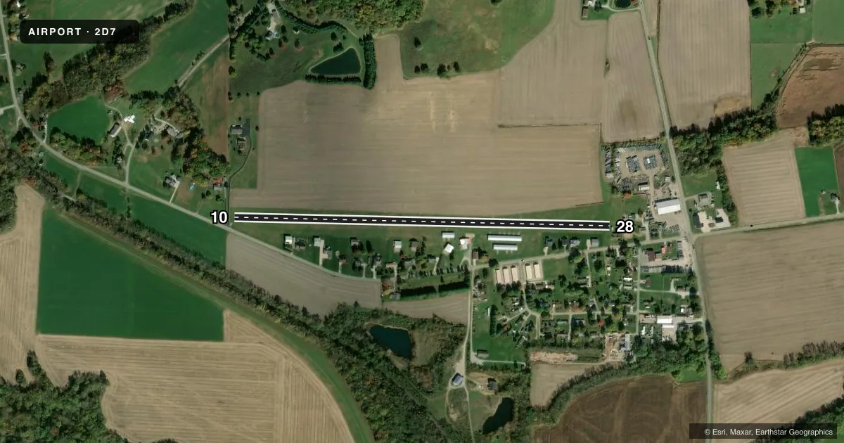
Airport sketch
Runways drawn to scale from FAA survey coordinates, rendered over satellite imagery. Not for navigation.
Approaches & charts
Services on the field
Fuel grades, oxygen, maintenance, ramp storage and lighting — as declared to the FAA by the airport operator.
Fuel & services
- Fuel
- Not available
- Oxygen (bottled)
- Not available
- Oxygen (bulk)
- Not available
- Airframe repair
- Not available
- Power plant repair
- Not available
Ramp & ground
- Transient storage
- Tie-down
- Hangar
- Landing fee
- No fee published
- Customs
- Not available
- Lighting schedule
- SEE RMK
- Beacon schedule
- SEE RMK
- Beacon
- White / Green (civil land)(WG)
- Wind indicator
- Lighted
- Segmented circle
- No
Fuel & FBOs
Cheapest 100LL and Jet A on the field and nearby. Always confirm with the FBO before taxi.
Airport notes
Surface conditions, obstructions, local procedures, lighting outages and other notes published with each FAA cycle.
General notes
- NO ULTRALIGHT ACFT WI 1 NMR.
- ARPT CLSD TO MIL HELS.
- FOR CD CTC CLEVELAND APCH AT 216-352-2323, WHEN APCH CLSD CTC CLEVELAND ARTCC AT 440-774-0223/0490.
- DEER, BIRDS, & WILDLIFE ON & INVOF ARPT.
- SEASONAL CROPS AT RWY EDGE, NORTH SIDE.
Lighting notes
- ACTVT ROTG BCN SS-SR - 122.85.
- ACTVT NSTD LIRL RWY 10/28 SS-SR - 122.85.
Runway surface & condition
- 10/28NSTD LIRL DUE TO LCTN ON YELLOW CONES & UNLGTD BFR EACH DTHR (2016 FT LGTD).
Approach & departure obstructions
- 102016 FT MKD WITH LIRL ON YELLOW CONES; DTHR MKD WITH 1 GREEN LGT ON YELLOW CONE EACH SIDE; NO MKGS BFR EACH DTHR.
- 282016 FT MKD WITH LIRL ON YELLOW CONES; DTHR MKD WITH 1 GREEN LGT ON YELLOW CONE EACH SIDE; NO MKGS BFR EACH DTHR.
- 10APCH SLP 9:1 TO DTHR OVR +35 FT PLINE, 321 FT DIST, 157 FT L.
- 28APCH SLP 0:1 TO DTHR OVR +16 FT HNGR, 0 FT DIST, 110 FT L.
- 10ALSO +10 FT ROAD, 0 FT DIST, 0:1.
- 28ALSO +13 FT BLDG, 61 FT DIST, 0 FT B, 4:1.
Other notes
- ESTABD BFR PART 157.
VFR map & nearby airports
VFR sectional. Tap any ICAO chip to open that airport.
Key facts · 2D7
Answer card- ICAO
- 2D7
- Name
- BEACH CITY
- Location
- BEACH CITY, OHIO
- Elevation
- 984 ft MSL
- Traffic pattern altitude
- 1,800 ft MSL (816 AGL)
- Control tower
- Non-towered (use CTAF)
- Total runways
- 1
- Longest runway
- 10/28 · 3,175 ft
- Published ILS approaches
- 0
- Published frequencies
- 4
- Magnetic variation
- 6°
- Current flight rules
- VFR
- Current wind
- 130° at 4 kt
- Favored runway now
- RWY 10
Beach City Airport sits in Beach City, Ohio. The field elevation is 984 ft MSL. It has one runway. Runway 10/28 is 3,175 ft of turf, which is the longest runway on the field. There is no control tower. Pattern altitude is 816 ft AGL, which is 1,800 ft MSL.
No ILS approaches are published here. That matters if you are planning an IFR arrival. Use the current chart and be ready to work with Cleveland Approach or Cleveland ARTCC for clearance delivery when needed. The published remarks also note nonstandard low intensity runway lights on runway 10/28. The lighted length is 2,016 ft. Runway 28 has displaced threshold markings and nearby obstructions. Runway 10 has a power line on approach. Seasonal crops sit at the runway edge on the north side. The airport is closed to military helicopters.
There are no on-field FBOs listed, so plan ahead for services before you go. The beacon activates from sunset to sunrise on frequency 122.85. This is a turf strip with published obstructions, so first-time visitors should brief the runway environment carefully and expect a more hands-on arrival than a paved field.